Yes, there are a number of differences. Some major and some minor.
Arguably, the single most important difference is that Litchi includes their Mission Hub. The Mission Hub provides a way to interactively configure missions using the large screen and comfort of your desktop computer. With this system one can even simulate the flight in Google Earth Pro prior to flying it with a drone. Using DJI waypoints, one is constrained to using the screen of the flying device which is often much smaller than a desktop monitor.
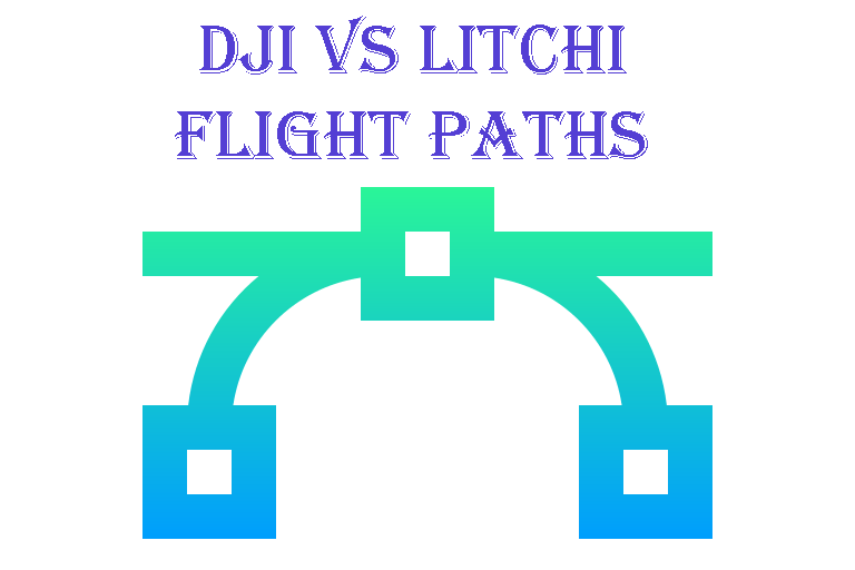
Another important difference is how both Litchi and DJI create a flight path defined by waypoints. With Litchi, the waypoints define the bounding box of the mission where the flight path does not necessarily pass through the waypoints. With DJI, the flight path does pass through each waypoint. Initially, one may thing that having the flight path pass through each waypoint makes more sense. However, having the waypoints define the bounding box of the mission has advantages. There have been cases where people have designed missions using the DJI platform only to find that the resulting flight path passes closer to the ground than any of the waypoints (outside of the bounding box) which can result in a crash. More details about the difference in flight paths can be found here:
Litchi and DJI waypoint paths are computed differently. This document will describe how those paths are computed and the advantages of each method.
www.litchiutilities.com
As you mentioned, another feature of Litchi is the ability to specify the above-ground height (as opposed to the above take-off height). To do this, Litchi uses elevation data to convert the specified above-ground height into above take-off heights used in the drone.
There are other difference relating to "waypoint actions" where Litchi provides a bit more flexibility than DJI Fly.
I have created a suite of utilities that extend the capabilities of Litchi. One of those utilities can be used to convert a Litchi mission into one compatible with DJI Fly for your
Mini 4 Pro. This way, you can continue to use the superior Litchi Mission Hub to plan your mission but then convert it into a mission for your
Mini 4 Pro.
Web utilities used to design, convert, and create Litchi waypoint missions. Conversions to other popular waypoint formats are also available.
www.litchiutilities.com


 and good to know.


 Would an outdoor WIFI 6 range extender interfere with DJI drone flights?
