DJI Mavic, Air and Mini Drones
Friendly, Helpful & Knowledgeable Community
Join Us Now

Documenting a construction project

WahooBadger

Active Member
Joined
Sep 17, 2020
Messages
36
Reactions
32
Age
79
Location
Fork Union, Virginia
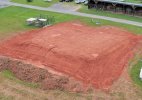
A nonprofit animal sanctuary where I volunteer has begun a project to provide better housing for the dogs that reside there. Over the next few months, I will be providing drone coverage of the process with stills and video. I would like to be able to position my drone - Mavic 2 Zoom - at a designated spot once on every mission to so I can put together at the end a start to finish series of photos taken from the same overhead position. The only way I can think of to do this would be to save a single point waypoint mission with a single point of interest, and have the drone take a photo when it reaches the waypoint. Since the actual building will be changing as construction takes place, I'm guessing the point of interest would have to be something that will NOT change, but will allow the construction project to always be in the field of view of the camera.

Ideas/thoughts appreciated. I am 107 certified. Photo from a couple days ago after site was leveled for footers etc.
 

Attachments

  • 2 aug pic 1 copy.JPG
    2 aug pic 1 copy.JPG
    672 KB · Views: 3
  • Like
Reactions: Rchawks
If there's any risk that construction activity on one part of the structure could obscure the drone's view of progress on other parts, then you might want to consider more than one vantage point.
 
  • Like
Reactions: Cafguy
If there's any risk that construction activity on one part of the structure could obscure the drone's view of progress on other parts, then you might want to consider more than one vantage point.
I thought about that after I wrote the post, and will do two or three waypoints. If I have one waypoint, can I fly to it and then point the drone directly to the site and shoot photos manually? I've only used waypoints where the drone would take photos at points of interest, or take video while flying the route. The manual was no help on this topic.
 
The only way I can think of to do this would be to save a single point waypoint mission with a single point of interest, and have the drone take a photo when it reaches the waypoint.
I'm pretty sure the minimum number of waypoints in a mission is two. I know this is a requirement for Litchi. It is also most likely a requirement for a native DJI Go 4 mission as well. In any case, all you would need to do is to create two non-coincidental waypoints with the second one having a "take photo" action.

Since the actual building will be changing as construction takes place, I'm guessing the point of interest would have to be something that will NOT change, but will allow the construction project to always be in the field of view of the camera.
By definition, a POI, as they are used in waypoint missions, are static. They are defined by latitude, longitude, and height. You will want to make sure the site is framed with sufficient space around, below, and above the project. No two waypoint missions are flown with precisely the same parameters (there is always some error). Therefore, you will be required to apply offsets in post if it is desired to have the photos show exactly the same position when completed.

I thought about that after I wrote the post, and will do two or three waypoints.
While you could set this up manually, I have a Litchi utility created exactly for this type of project. It is called a "Cardinal Directions Photo Mission". Of course, it would require that Litchi be used instead of Go 4.

 
A nonprofit animal sanctuary where I volunteer has begun a project to provide better housing for the dogs that reside there. Over the next few months, I will be providing drone coverage of the process with stills and video. I would like to be able to position my drone - Mavic 2 Zoom - at a designated spot once on every mission to so I can put together at the end a start to finish series of photos taken from the same overhead position. The only way I can think of to do this would be to save a single point waypoint mission with a single point of interest, and have the drone take a photo when it reaches the waypoint. Since the actual building will be changing as construction takes place, I'm guessing the point of interest would have to be something that will NOT change, but will allow the construction project to always be in the field of view of the camera.

Ideas/thoughts appreciated. I am 107 certified. Photo from a couple days ago after site was leveled for footers etc.
Old school solution, to save the head scratching. Spray a series of small circles on the grass around the site, however many will cover all the angles you want to shoot

When you want to update the photo sequence: place drone on your GCP (the sprayed spot). Take off in a straight vertical ascent to your predetermined altitude, yaw around to the correct orientation and take your shot.

Rinse & repeat as many times as you need.

K.I.S.... Keep It Simple.
 

DJI Drone Deals

New Threads

Forum statistics

Threads
138,010
Messages
1,633,023
Members
166,496
Latest member
Virginia Droner
Want to Remove this Ad? Simply login or create a free account