A nonprofit animal sanctuary where I volunteer has begun a project to provide better housing for the dogs that reside there. Over the next few months, I will be providing drone coverage of the process with stills and video. I would like to be able to position my drone - Mavic 2 Zoom - at a designated spot once on every mission to so I can put together at the end a start to finish series of photos taken from the same overhead position. The only way I can think of to do this would be to save a single point waypoint mission with a single point of interest, and have the drone take a photo when it reaches the waypoint. Since the actual building will be changing as construction takes place, I'm guessing the point of interest would have to be something that will NOT change, but will allow the construction project to always be in the field of view of the camera.
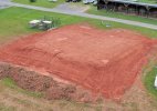
Ideas/thoughts appreciated. I am 107 certified. Photo from a couple days ago after site was leveled for footers etc.
Ideas/thoughts appreciated. I am 107 certified. Photo from a couple days ago after site was leveled for footers etc.