DJI Mavic, Air and Mini Drones
Friendly, Helpful & Knowledgeable Community
Join Us Now

Drone photo with gps location latlong and with date and time

Looks like the location of the user, not the drone. Only way I know to get the drone Lat/Longs on screen is with Litchi. Hard to keep up with the times though.
 
Looks like the location of the user, not the drone. Only way I know to get the drone Lat/Longs on screen is with Litchi. Hard to keep up with the times though.
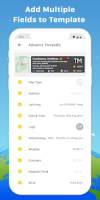
It’s reading GPS location from the EXIF data in the photo file, so it can tag the location of the drone camera. Then it’s layering it with geographic data of where those coordinates are on Earth. Looks like a nice app.
 
Umm guys... that's not a drone app. It's an Android app where you can pick the kind of view for the map. There are many to choose from. See my link above. 1734038716286.png You'll notice the main photo was taken while standing on terra firma.
 
  • Like
Reactions: tstr14
Umm guys... that's not a drone app. It's an Android app where you can pick the kind of view for the map. There are many to choose from. See my link above. View attachment 179691 You'll notice the main photo was taken while standing on terra firma.
Thanks, yeah, it’s a photo editing app. And it should work as a post-processing editor on drone photos, phone photos and everything recording GPS positions on their EXIF files will work, but sadly Instamatic photos will not work on it.
 

DJI Drone Deals

New Threads

Forum statistics

Threads
135,046
Messages
1,601,585
Members
163,535
Latest member
spamdrop719
Want to Remove this Ad? Simply login or create a free account