I'm trying to use Virtual Litchi Mission 2.4.0 & Google Earth to preview and plan flights before arriving on site with my drone. I'm getting very inconsistent results and I have no idea why. My drone is flying along the planned path correctly but it rotate's which as far as I can tell, is nowhere in my flight plan. From waypoints 3-4 it flies as intended. I've also tested this out with the actual drone at the mission site and it does the same thing that the google earth recording does.
Here's a google earth recording of the issue.
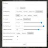
VIRTUAL LITCHI MISSION SETTINGS

LITCHI SETTINGS


Here's a google earth recording of the issue.
VIRTUAL LITCHI MISSION SETTINGS

LITCHI SETTINGS


