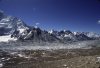
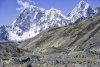
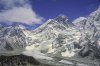
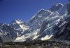
In the year 2000, at age 62 I did the trek to Kala Pattar, 18,500ft and looked down at Everest Base camp (17,500 feet- 17 days on trail) and saw the Everest massif from Kala Pattar (18,500 feet marked on the map). I received this insert today in my NationalGeographic Magazine, featuring Mt Everest on the cover. The image was taken from a base camp, the drone was flown to 3900 feet away and 26 image panorama taken.The photographer had 15 minutes of battery life due to the extreme cold. I thought I would share it with the Forum. You might need to scroll to see entire image.