DJI Mavic, Air and Mini Drones
Friendly, Helpful & Knowledgeable Community
Join Us Now

First real flight today.

wco81

Well-Known Member
Joined
Nov 16, 2018
Messages
1,348
Reactions
397
Age
125
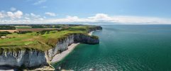
It was in the Southern coast of France, near San Raphael. The terrain is a rocky coast with red rocky mountains rising above the water.

I went to a rocky headland called Cape Draymont. There is a hiking trail which leads out toward the water but I didn’t head out too far because I wasn’t sure I’d find flat enough terrain to take off and land.

First thing I noticed, didn’t have to recalibrate the compass like I did each time with the Mavic 2 Pro.

Got a lot of footage flying a couple hundred feet to the east of where I was and then I flew south. About 700 meters to the south, it lost the signal when it got beyond the other side of the rocky headland from where I was. I’d estimate the rocky headland rose 200-300 feet so the drone wasn’t too much above the highest point.

My screen showed the last image before signal was lost. I waited a couple of seconds, figured it would RTH. But it didn’t so I hit RTH button and then the signal came back so I canceled RTH and did some more filming. But I didn’t try to get too much further away before signal was lost again and I initiated RTH, then canceled when it regained signal.

Still had 35-40% battery so got the drone above 350 meters from HP and did more filming. Finally did RTH and while it was descending vertically, a seagull flew across its path a couple of times. I dropped it faster and landed without any more issues but I really thought the seagull would take it down.

Swapped battery and tried again, tried to stay close to home. Now two seagulls were aggressively passing by it. Maybe it was trying to scare it. I descended to about 30-40 meters and the seagulls kept aggressively flying towards it. I made it drop fast. Someone said they’re threatened because they have a nest nearby.

Makes sense but it was near parking and there were people on kayaks and small motor boats making noise.
 
Yeah I landed and left, drove down about 4-5 miles where it was only a 50 meter zone and flew without incident.

I could have probably hiked maybe half a mile, though it would have been up and down and again, I wasn't sure if there would be a nice flat terrain from which I could take off.

I actually have rails which raise the propellers by about 1-1.5 inch higher but I forgot to take them with me.
 
  • Like
Reactions: 1gratefulflyingdawg
Are people seeing the same thing when it loses signal with the aircraft?

It doesn't automatically RTH on its own. I had to initiate it with the RTH button on the controller at least twice before it started coming closer enough to home, maybe 25-50 meters from it's previous position, before the signal reconnected?

If signal has been lost, how was I able to trigger the RTH on the controller?
 
  • Like
Reactions: 1gratefulflyingdawg
There is a time lag for the RTH when signal is truly lost. I can’t remember what that duration of time is. Possibly someone else has that information.
 
Are people seeing the same thing when it loses signal with the aircraft?

It doesn't automatically RTH on its own. I had to initiate it with the RTH button on the controller at least twice before it started coming closer enough to home, maybe 25-50 meters from it's previous position, before the signal reconnected?

If signal has been lost, how was I able to trigger the RTH on the controller?
Obviously you cannot initiate RTH when signal is lost.
Your drone probably initiated RTH itself, just as it is programmed to.
If in any doubt, you could always check the recorded flight data to see what actually happened.

But RTH is now a lot more sophisticated than it was for your previous model.
The drone might not have behaved the way you expected it to.
Suggest you read the RTH section of the manual, starting on page 4i here:

Particularly the Loss of Signal section on page 44.
Then go and see how this works by flying out >50 metres and switching the controller off.
 
Yeah I landed and left, drove down about 4-5 miles where it was only a 50 meter zone and flew without incident.

I could have probably hiked maybe half a mile, though it would have been up and down and again, I wasn't sure if there would be a nice flat terrain from which I could take off.

I actually have rails which raise the propellers by about 1-1.5 inch higher but I forgot to take them with me.
Best solution for really rough terrain? Hand launch: hand land. To be honest, I haven't launched a drone from the ground in over six years.
 
Now two seagulls were aggressively passing by it. Maybe it was trying to scare it. I descended to about 30-40 meters and the seagulls kept aggressively flying towards it. I made it drop fast. Someone said they’re threatened because they have a nest nearby.
When birds are too interested, it's better to climb than descend. If you climb at a fast rate, the birds can't match that maneuver since it's not something they are accustomed to in nature. In all probability, if they're really pissed, they can out dive your drone.
 
When birds are too interested, it's better to climb than descend. If you climb at a fast rate, the birds can't match that maneuver since it's not something they are accustomed to in nature. In all probability, if they're really pissed, they can out dive your drone.
If you are dealing with determined birds, the more you climb, the more your drone will be exposed getting back down.
 
Moved to a different part of France, this time the northern coast, which has beautiful white cliffs with limestone stacks which have unusual shapes. They call them falaises off the coast of Etretat.

First afternoon that I arrived I hiked up without the drone. I concentrated on taking photos with my Nikon. Lot of stairs and climbing to get to the top of the cliffs, where you can look down at the coastal town surrounded by the cliffs.

But what I saw was a lot of seagulls. In fact the seagulls were on the ground right near the edge of many of these cliffs, not in the least threatened by the throngs of tourists, who were taking pictures not just of the scenery but the birds as well.

I wondered if they were near nests and the seagulls were marking their territory. So if I tried to fly here would I see the same behavior I saw down south?

Next day there was a lot of fog and you could barely see the cliffs so I didn't bother to take my Air 3S on a hike up another cliff.

Today, the morning was very overcast but no fog. It rained overnight as well. But around 2 PM, the skies opened up and you had all this sun so I took my drone up to the cliffs. There were a lot of people. In fact, I may have as many problems finding a place to take off and land as dealing with protective seagulls.

I found a relatively sparse area and took off but I did not venture out over the cliffs, over the water. I started flying only 30-40 meters from Home to see if the seagulls would swarm to the drone. They didn't so I went up all the way to 120 meters.

But I stayed mostly over the top of the cliffs, not venture too far out over the thin beach and the ocean below. I only used one battery and the flight time is excellent. I would say at least 50% more time than my old Mavic 2 Pro, maybe double the time.

Away from the town of Etretat, it's suppose to be clear, no restrictions up to 120 meters AGL. But I see plenty of aircraft, helicopters, fixed wing and even an ultralight.

They don't seem to be flying that much higher, maybe 200-300 meters above the top of the cliffs where I was. I got warned of manned aircraft in the DJI Fly app twice.

It told me to be careful and showed the helicopter flying by. For the most part they flew out over the water, not too far from the cliffs, while I stayed over the top of the cliffs. I just moved further inland and dropped down in altitude, as low as 30-40 meters AGL.

There was one helicopter, which went by west to east. I dropped altitude and headed southwest. But then it turned around and headed back west again and went also towards the southwest. It's almost as if it wanted to see what it was. Presumably my RID showed up on his instruments as well?

It didn't look like some police or any other official helicopter. I'm not sure what kind of aircraft they run around here. Maybe police and air ambulances but also maybe there are some leisure flights, since the area is stunningly beautiful from the air, especially flying over the ocean, cliffs, and wide expanses of pastures, a golf course, etc.

I went by the French Geoportail site and as far as I know, other than the towns in this sparsely developed area, there are no restrictions.

When that helicopter seemed like it was coming to intercept, I started RTH and then as it started to descend, I saw that the helicopter moved out of range so I canceled RTH and kept shooting. Again, one battery gives you a lot o flight time to do different captures.
 
Presumably my RID showed up on his instruments as well?
On his cell phone, maybe. A small helicopter wouldn't have radar or other means of detecting a drone.
When that helicopter seemed like it was coming to intercept,
It's unlikely the pilot had any idea that you were there, unless he noticed a person on the cliff in the classic "two hands on the sticks, staring at the controller" drone operator posture.

Why would a helicopter pilot be interested in "intercepting" a small recreational drone? No reason to assume a threat. Most likely just another person admiring the scenery.

It sounds like a wonderful place to fly. Why not share a photo or two?
 
Going to try to attach some panos out of the drone.
 

Attachments

  • DJI_20250719152237_0004_D.JPG
    DJI_20250719152237_0004_D.JPG
    8.1 MB · Views: 6
  • DJI_20250719152426_0005_D.JPG
    DJI_20250719152426_0005_D.JPG
    8.1 MB · Views: 6
  • DJI_20250719153058_0009_D.JPG
    DJI_20250719153058_0009_D.JPG
    8.6 MB · Views: 6
  • Like
Reactions: MS Coast

DJI Drone Deals

New Threads

Forum statistics

Threads
137,786
Messages
1,630,914
Members
166,304
Latest member
Rodzlla
Want to Remove this Ad? Simply login or create a free account