DJI Mavic, Air and Mini Drones
Friendly, Helpful & Knowledgeable Community
Join Us Now

Fly app and terrain following

AntoineD

Member
Joined
Sep 15, 2022
Messages
18
Reactions
1
Age
64
Location
Worcester, UK
I'm about to buy a Mini 4 Pro, which unfortunately doesn't seem to use my favourite control app, Litchi.

I understand that the Fly app will do waypoints, but there's one feature it doesn't seem to have that I got on Litchi. On the Litchi app, you could select every waypoint and get it to set the height above that particular spot on the terrain rather than the height of your home point, which meant it could follow the contours of the landscape without any worry that it would collide with anything.

If the Fly app doesn't let you do this, can you install some sort of add-on, or even a different control app, into the RC2 controller?
Does the app perform terrain analysis to determine if the flight between the waypoint will be safe?
 
I'm about to buy a Mini 4 Pro, which unfortunately doesn't seem to use my favourite control app, Litchi.

I understand that the Fly app will do waypoints, but there's one feature it doesn't seem to have that I got on Litchi. On the Litchi app, you could select every waypoint and get it to set the height above that particular spot on the terrain rather than the height of your home point, which meant it could follow the contours of the landscape without any worry that it would collide with anything.

If the Fly app doesn't let you do this, can you install some sort of add-on, or even a different control app, into the RC2 controller?
Does the app perform terrain analysis between the waypoints, to ensure the flight over them are safe?
 
The Litchi app follows the contour levels of the topographic map to ensure the flight is always above the set altitude above the ground (not the home point) before takeoff.
What if there is a hill in between the waypoint flight path that is higher than both the waypoint heights?
 
Does the app perform terrain analysis between the waypoints, to ensure the flight over them are safe?
What if there is a hill in between the waypoint flight path that is higher than both the waypoint heights?

And remember that the hill may have trees, power lines, or towers on it.

Planning a safe flight is the pilot's job. Apps and waypoint functions just execute the pilot's flight planning, but may do a few very basic sanity checks.
 
Last edited:
What if there is a hill in between the waypoint flight path that is higher than both the waypoint heights?
So in short, there is no terrain analysis by the app other than using your eyeballs?
If activating "Use online elevations" in the settings & marking the checkbox "Above ground" on each waypoint... the set height for each waypoint will be above ground right below the waypoint & not relative the takeoff point.

This works ok, but what happens between the waypoints is up to you, no flight path analysis will happen taking into account high points in between the waypoints.

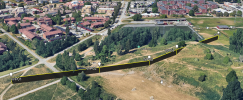
Here an example when flying over a smaller hill where each waypoint is set to a height of 5m above ground... the terrain i pretty much flat from WP01 to WP03, then the path is elevated up to WP04, but then... check what happens between WP04 & WP05.

1743357707578.png

1743357772414.png
 
Does the app perform terrain analysis to determine if the flight between the waypoint will be safe?
No, it doesn't.
The Litchi app follows the contour levels of the topographic map to ensure the flight is always above the set altitude above the ground (not the home point) before takeoff.
Not exactly.

I have a detailed description of how Litchi's "Above Ground" works here:

 
I agree with you that my answer was not containing all the nitti gritti of a flight planning. When Litchi takes into account the ground level from the topographic maps contours from waypoint to waypoint, It does not add the height of all the objects existing above the ground levels, such as trees, antennas, buildings, etc. If you start your flight in a flat prairie and continue toward some forested hills, you have to add to the topographic heights of the coming hills a precise estimation of the tree heights and other artificial artefacts above the ground. And to give a chance to the drone to adjust in advance its altitude for a coming steep topographic change, more waypoints are better that missing waypoints.
 
  • Like
Reactions: Felix le Chat
I agree with you that my answer was not containing all the nitti gritti of a flight planning. When Litchi takes into account the ground level from the topographic maps contours from waypoint to waypoint, It does not add the height of all the objects existing above the ground levels, such as trees, antennas, buildings, etc. If you start your flight in a flat prairie and continue toward some forested hills, you have to add to the topographic heights of the coming hills a precise estimation of the tree heights and other artificial artefacts above the ground. And to give a chance to the drone to adjust in advance its altitude for a coming steep topographic change, more waypoints are better that missing waypoints.
Thanks for the valuable information. I just need to figure out what the added-value Litchi app bring to the table vs. existing DJI waypoints function. Thanks.
 
I agree with you that my answer was not containing all the nitti gritti of a flight planning. When Litchi takes into account the ground level from the topographic maps contours from waypoint to waypoint, It does not add the height of all the objects existing above the ground levels, such as trees, antennas, buildings, etc. If you start your flight in a flat prairie and continue toward some forested hills, you have to add to the topographic heights of the coming hills a precise estimation of the tree heights and other artificial artefacts above the ground. And to give a chance to the drone to adjust in advance its altitude for a coming steep topographic change, more waypoints are better that missing waypoints.
This is the single feature of Litchi that managed to impress me the most.
 
I completely agree with you...and also the possibility to repeat with great precision your flights at different seasons or circumstances in order to make some good morphing videos. Example:
To view this content we will need your consent to set third party cookies.
For more detailed information, see our cookies page.
 

DJI Drone Deals

New Threads

Forum statistics

Threads
136,317
Messages
1,616,064
Members
164,906
Latest member
flyingatalef
Want to Remove this Ad? Simply login or create a free account