I think I sort of managed to work around these issues now. Here's what I do:
I fly to the starting point, camera down, heading in the direction I want the first leg to go, then move sideways to the desired overlap. Camera forward so I see where I'm going, then I fly backwards a few seconds, then full speed forward and engage cruise control. Note that cruise control remains engaged when going into the waypoints mode, but you need to engage it beforehand. Then tap the waypoints button and then start clicking C1 overflying the start point, and click every 5-10 seconds. Because CC is on, I just need to use left stick for track control, turn around at the end of the first leg, map display full screen now so I can maintain approximately the correct offset between tracks. Before every turn, I mark a waypoint, and during the turn I do about 3-4 waypoints. That seems to keep the track relatively straight where I want it.
Then I edit the waypoints when done, apply global gimbal angle to -85 degrees, set the start and end recording waypoints (first and last usually) and come back to change battery, and start with a fresh battery. Creating the grid usually takes me about 60-80% of a charge.
Insert new battery, power on, and hit go from while on the ground still, and it does the whole thing on its own. Pretty cool.
Glad I bought 5 batteries...
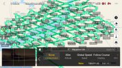
Attached is what that looks like on my screen.


 Air 3 Pebbly Beach - Mid North Coast, Black Head NSW, Ausralia.🦘🇦🇺

