DJI Mavic, Air and Mini Drones
Friendly, Helpful & Knowledgeable Community
Join Us Now

GPS from photo.

Magicapeboy

New Member
Joined
Nov 27, 2019
Messages
1
Reactions
0
Age
49
Location
New Zealand
Hi All, I've done some work for a conservation group and we need the GPS from the photos, I've done the usual after downloading and looked on the file info and it's not there, did DJI do an update which took this off?
Thanks for your help!
 
The data is there, it is just not in plain view. What you need it to get a utility like EXIF Viewer for a Mac or its equivalent for PC. Sometimes just get info for your file will reveal it. Photoshop and other programs will let you see file data as well. Remember, the position will be where the drone was, not necessarily what the picture is of.

Position Data in Preview on a Mac, it is under the GPS box in the file info tool.

Screen Shot 2021-03-27 at 4.08.02 PM.jpg
 
Last edited:
No special software needed.

- Open file explorer in windows.
- Right click on the file and click "properties" to view the photo's properties.
- One of the tabs (maybe "details"?) will show the EXIF data embedded in the photo including the GPS coordinates.
 
  • Like
Reactions: ckoerner
Hi All, I've done some work for a conservation group and we need the GPS from the photos, I've done the usual after downloading and looked on the file info and it's not there, did DJI do an update which took this off?
Post one of the full-size images that's giving you problems and I'll look into the metadata with some industrial=strength software to see what's going on.
 
Okay I couldn't find it on any of my photos. Is it because they have been edited??
Not necessarily.
Editing usually doesn't change it, but if you copied the image to a new document the metadata will be lost on the new file.
If you can post one of your image files, I'll check and show you where to find the location data.
 
Not necessarily.
Editing usually doesn't change it, but if you copied the image to a new document the metadata will be lost on the new file.
If you can post one of your image files, I'll check and show you where to find the location data.
 

Attachments

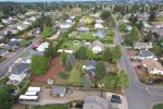
  • neighborhood.jpg
    neighborhood.jpg
    9.6 MB · Views: 10
That's an interesting one.
When I open it in Photoshop and check File .. Info, it would usually show the location data and a lot of other metadata.
It does have basic camera data, but no location data.
But when I examine it in a specialised metadata viewer, it's all there.
It looks like the editing has affected things a little.
I would expect an un-edited file would show location data with Photoshop etc.
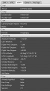
Here's the section with the location data:

Metadata.jpg
 
That's an interesting one.
When I open it in Photoshop and check File .. Info, it would usually show the location data and a lot of other metadata.
It does have basic camera data, but no location data.
But when I examine it in a specialised metadata viewer, it's all there.
It looks like the editing has affected things a little.
I would expect an un-edited file would show location data with Photoshop etc.
Here's the section with the location data:

Thanks so much for help on this. The picture I sent you was not edited, but I did have to send from my DJI Album in my cell phone to my PC. There was a post the other day where a member from Sweden showed where the data was (in the Details tab). I hope it is not a setting in the DJI Fly program, as I will have lots of egg all over my face!
 
Yeah ... the transfer via DJI Album might have altered thing's in the exif making Windows not getting the position up under the properties. But the position is there though ... have attached the complete exif from "Exif Tool" in a .txt file (scroll close to the end for the position).

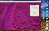
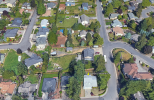
And here the position in Google Earth ... looks like the photo. 😁

1652302055635.png
 

Attachments

Yeah ... the transfer via DJI Album might have altered thing's in the exif making Windows not getting the position up under the properties. But the position is there though ... have attached the complete exif from "Exif Tool" in a .txt file (scroll close to the end for the position).

And here the position in Google Earth ... looks like the photo. 😁

View attachment 148176
I always download the photos from the drone to my cell phone. Would I be better off downloading from the SD card directly to the PC if I want the GPS info??
 
I always download the photos from the drone to my cell phone. Would I be better off downloading from the SD card directly to the PC if I want the GPS info??
Maybe ... it depends on where the modification to the metadata happened.
Neighbourhood.jpg isn't a DJI filename, so it's not an untouched original DJI image.
You could do some testing to check.
But if you download the original files from teh SD card, they will always have the location data included in the metadata.
 

DJI Drone Deals

New Threads

Forum statistics

Threads
134,578
Messages
1,596,454
Members
163,079
Latest member
jhgfdhjrye
Want to Remove this Ad? Simply login or create a free account