Huh ?
you said
" I also could see how I was moving the sticks. "
...in Google Earth PRO ?
How are your rc sticks linked to G Earth Pro?
As far as Elevation goes... you need to set the EXTRUDE Variable in your KLM -
for the Path
View attachment 176002
Huh?
Response lacked instructions and creativity.
Assume stick controls means rudder, but could be any other parameter (throttle, heading, battery voltage, pitch etc.).
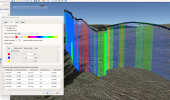
Download your FlightRecord. It is a CSV file.
Set Google Earth Tools>Option to Decimal Degree and Units to Feet (or whatever the parameters in FlightRecord.
Open in Google Earth File>Open. Set Type to CSV and select your flight record.
File is Delimited, Comma.
Use OSD Longitude and Latitude to set location. Finish.

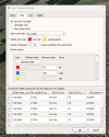
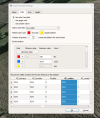
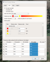
Create a Style Template.
Set Name as RC Rudder.
Set Color from Field as RC Rudder. Example shows palette colors as Red to orange to yellow with 3 buckets. In my file, 1024 was zero, so I set it as the mid value and orange. These settings can be adjusted to your preference.
Set Height from Field: OSD_Height_Feet. Continuous and Feet.

Red means right stick, yellow is left and orange is neutral. Values are amount of rudder relative to 1024. Could spend more time revising, but most of that is personal preference.

Google Earth is powerful, and stay creative.