Recently pre-planned a mission using the Hub and exported as KML to Google Earth with a serious discrepancy, not sure which data to trust at this point, Have emailed Litchi for response. Anyone experience this as well.
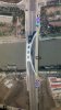
Typical POI mission
Image 1 ( planned mission in Hub)

Image 1 exported to Google Earth as KML (Notice severe offset)

Adjusted Mission in Hub to compensate for offset in KML

Adjusted Mission Hub data exported to Google Earth as KML

Typical POI mission
Image 1 ( planned mission in Hub)
Image 1 exported to Google Earth as KML (Notice severe offset)
Adjusted Mission in Hub to compensate for offset in KML
Adjusted Mission Hub data exported to Google Earth as KML