The relative to ground feature is a great feature and I've used it a few times on missions where the elevation was minimal but I struggle with understanding the difference between the altitude take off point and when the drone flies down into a valley or river bed. An example below might help someone to clear up my understanding or logic of why the altitudes are shown the way they are...
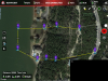
Scenario: Take off point 1 is at 727' above sea level. Point 4 (over river) is at 495' above sea level. The difference is 232'.
Mission 1: Drone is set to 100' above point 1 and all my points are set the same, so entire mission is 100' above take off point. I understand this to mean that, at point 4, over the river the drone is now approximately 332' over the river, using numbers from scenario above. (see attachment 1 for mission)
Mission 2: Drone is set to 100' above point 1. Then I load this mission on my iPad tablet and use the wrench to select all points, edit and change to 101' relative to ground (instead of take off point). Now. I see point 1 is 101', which I expect. But point 4, right over the river, is -130'. So Litchi app is taking the 232' difference between point 1 and point 4 and subtracting the 101' that I want the drone over land/water, right?
(see attachment 2)
So this all boils down to one question. Wouldn't it be better/easier to see point 4 in a way that let's me know the drone is actually 101 feet from the water. Or maybe the little bubble could show me -130/101 meaning -130' lower than take off point altitude. I'm just having a hard time wrapping my head around some of these missions when I see a negative or lower number than the start point. It's like I want to see another number relative to the ground it's flying over to know I'm really high enough.
I'm going to write the Litchi people and see what they say but I'm interested in thoughts about this feature from the community.