Hello Pilots,
Sadly this is my first post, but upon reading the success stories on the forum I got a glitter of hope.
I've went to a bicycle trip today and upon climbing a pretty long hill I wanted to record some of the surroundings and take a rest.
So I startup my Mavic Mini v1 and start to fly around, exploring the area from the air.
At the home point there was no/very little wind so I assumed it's safe to fly.
At first I got
Max Power Reached warning but i ignored it. Not so long after I got
Strong Wind Warning and lost control of MM so I hit RTH. I was flying in P mode the whole time,
Foolishly, I assumed there won't be issues with RTH so I waited for drone to regain control instead of landing it immediately.
As I waited the signal was lost. Went to the last seen location but I was unable to get connection.
I would really appreciate if I could get approx location on where to look.
Here is the log file -
DJI Flight Log Viewer - PhantomHelp.com
DAT file in the attachment
Thank you in advance!
I'm sorry ... but in this case it will be impossible to estimate any touch down location ... it can be all from the last position shown in your app with the "Find my drone" function ... or over 4,8km away from the last position.
All this due to that your Mini suffered from the dreaded "Uncommanded descent" decease due to deformed props that no longer could tilt the AC according to specification. In relation to your case this meant that the AC was very prone to drift with even lower wind speeds, much lower than what a healthy Mini could manage ... furthermore your Mini had lost so much thrust due to the deformed props that it actually no longer could maintain the height ... it was constantly slowly descending.
Your RTH height was set to 31m but your Mini just managed to reach 21m until it started to either keep a constant height or lose it.
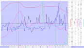
From the chart below produced from your log I have pictured a part from the RTH period where the maximum height was reached (red graph) ... we see that the AC drifts (with a average speed of just above 4m/s) with the wind as the distance to HP increases (light blue graph). No stick inputs is made there at the top height but the AC looses height & have in average a tilt angle (dark blue graph) of just 10-15 degrees (according to spec it should be 20). So most probably your 2 rear props couldn't produce enough thrust to set the AC to the correct tilt & at the same time the thrust was so bad that it couldn't keep the height... or ascend to the 31m that the RTH height was set to.

If we compare the vertical speed with what was commanded (you were in RTH & the AC was in progress to ascend to 31m = full throttle input generated from the RTH automation).
We see that you applied a lot of manual throttle inputs also (black graph) despite being in RTH ... mostly for ascending. But despite this the AC looses height (red graph) & the vertical speed (dark green) shows mostly positive values ... which is in the direction of descending.

So the problem here is that we don't know if the height instability improved later when the connection was lost or if the loss of height continued ...
Taking the very last values from the log gives a very long remaining battery until auto low battery landing should kick in (which was defined automatically to 5%) ... but the touch down could have happened much faster due to the "Uncommanded descent".
The big white gap in the chart below is a period where your RC was disconnected ... so no log could be recorded to your mobile device. But later you recovered the connection shortly & the AC was accelerating & had a drift speed of 8,6m/s (yellow graph), the battery consumption ... if interpolated, was around 1% per 10,3sec. So with 55% battery left gives further 565,2sec of flight until low battery landing, this means a maximum drift distance of approx. 4,8km. But that speed is most probably a bit high ... the average calculated drift speed during the disconnect was 4,25m/s ... but that gives 2,4km anyhow ...

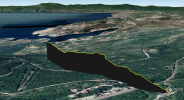
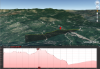
And hoping for some higher object in the drift path that might stop the AC is in vein unfortunately (if the height in the end of the log remained) ... this is how the terrain looked like in the drift direction, you took off from a high point & all terrain in the drift direction was lower. The distance to the water was approx. 4,5km.
This Mini is lost unfortunately ...


