Hello.
I've managed to mess things up again..
.I was flying towards a small hill with a steady incline and good visibility.
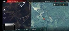
For some inexplicable reason, I decided to press the 'Return to Home' button to bring the drone back, and that's when the chaos started:The drone wanted to land right there and then.
I tried to abort the landing, but I was bombarded with messages and warnings, and to top it off, the Wi-Fi signal disappeared. Wiser from previous experiences, I took a screenshot of where the drone was on the map in the DJI GO4 app, and that turned out to be a lifesaver!
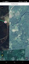
'Find My Drone' wasn't working, and it seems that the GPS coordinates are missing, making it impossible for me to check the flight log with the map.In the app, I had a clear idea of where the drone was located, so I hoped it would still be in that area.
There was a lot of underbrush and grass, but I had a UV flashlight that makes my Spark shine like, well..., a spark in the dark! . I couldn't find it despite searching in both daylight and darkness.Are any of you experts able to shed more light on where the drone might have gone?
Flight log: DJI Flight Log Viewer - PhantomHelp.com
I've managed to mess things up again..
.I was flying towards a small hill with a steady incline and good visibility.
For some inexplicable reason, I decided to press the 'Return to Home' button to bring the drone back, and that's when the chaos started:The drone wanted to land right there and then.
I tried to abort the landing, but I was bombarded with messages and warnings, and to top it off, the Wi-Fi signal disappeared. Wiser from previous experiences, I took a screenshot of where the drone was on the map in the DJI GO4 app, and that turned out to be a lifesaver!
'Find My Drone' wasn't working, and it seems that the GPS coordinates are missing, making it impossible for me to check the flight log with the map.In the app, I had a clear idea of where the drone was located, so I hoped it would still be in that area.
There was a lot of underbrush and grass, but I had a UV flashlight that makes my Spark shine like, well..., a spark in the dark!
. I couldn't find it despite searching in both daylight and darkness.Are any of you experts able to shed more light on where the drone might have gone?Flight log: DJI Flight Log Viewer - PhantomHelp.com