DJI Mavic, Air and Mini Drones
Friendly, Helpful & Knowledgeable Community
Join Us Now

MA2 suddenly wants to land!

DroneZone Samui

Well-Known Member
Joined
Feb 10, 2021
Messages
98
Reactions
209
Location
Thailand, Ko Samui
Site
www.flying-arrow.net
This morning, on the 3rd flight with my MA2, I first noticed a continuous beeping from the controller, but this stopped after about 1 minute. In the second half of the flight I got the message "Landing is being initiated",
and I was able to cancel the landing that had just started! This twice for no reason!

Fortunately nothing happens ..... but give me a little thought!
Are there people who can report something similar?
 
Last edited:
This isn't anything strange at all ...

DJI crafts will initiate the landing procedure when the VPS sensors on the belly of the craft sense something closer than 0,5m (or 1,64 feet) & you hold the throttle for descend.

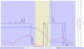
You had 2 instances of unintentional landings in this flight one at 431sec into the flight & one at 593sec. Below you have the last one depicted in a chart.

As you see, you held the throttle for descend (black graph) & at the same time the VPS height (red graph) was reported to be 1,6 feet ... & that started the landing. Have placed the chart markers just when the landing starts ... you can read out the graph values just there below the chart.

(Click on the chart to make it larger)
1620803987296.png

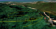
Most probably you passed a tree there ...

1620804050679.png
 
Okay .... thank you very much...

So there is nothing abnormal and everything works fine. Presumably both times there were branches below the drone.....
(i was just a little bit over the trees in the jungle....) but it's still not good if the MA2 then automatically initiates the landing ..... and deactivate the Belly-VPS is also not possible....Yes?

And i am sure that i was at least 2-3m over the branches...good to know now...
 
Last edited:
... and deactivate the Belly-VPS is also not possible....Yes? And i am sure that i was at least 2-3m over the branches ...
So if the VPS sensors had been off, together with your belief that you were 2-3m above the tree ... you had crashed instead... a better scenario?

If you look closer into the chart & the red VPS height graph just before & a bit into the autolanding phase (the brownish back ground color) you see that it took over 3sec with you applying max throttle down before the landing actually started (from approx 592sec to 595sec)... during these 3sec the craft didn't descend at all instead it gained some height (looking at the blue height relative HP), this to prevent you from crashing.

But as you persisted & kept the throttle down ... it started to land.
 
And i am sure that i was at least 2-3m over the branches...good to know now...
The lens on the drone's camera has a very wide angle.
That makes everything look a lot further away than it really is.
To put that another way ... your drone is closer to the branches than you realise.

I started listing the times you flew closer than 2 metres (VPS height) but there were so many I left about half off this list.
At 124.5 seconds your drone was so close to the branch below it, that the VPS height indicated went 2.3 metres, 1.0m, 0.3m, 0m (heights at 1/10th second intervals.

At 149.1 seconds it was back to 1.3 metres
At 152.2 sec it was 1.3m - 1.6m
AT 238 sec it was 1.7m
At 327 sec - 2.0m
At 344.4 sec - 2.0m
At 380.3 sec - 1.6m
......
At 432.8 sec - 0.3m
...
At 595.2 sec - 0.3m

Your obstacle avoidance sensors are not reliable with thin branches.
Flying so close to tree tops is very risky and likely to be the cause of losing your drone.
 
To be sure, I just tried it again in my garden. VPS starts to beep slowly from about 3-4 m above a dark surface.
In the sun over a bright, white roof, the beeping comes much later from a height of only 1 m. As far as clear ...
What is not clear why no beeping could be heard, which would have warned me ...?

I often checked out the low flight level with slow forward speed, and than the actual faster backward flight should be as you can see in the video sample....

Okay, thank you for helping and always good flight...
You seem to miss a very key thing Slup and others are telling you. You have throttle down at the time, which starts the descending / landing process when close to an object the drone may perceive as the ground.

The drone simply does what YOU the pilot tell it and when throttle down stick - it starts dropping like it is going to land. You have to recognize what your hands are doing on the sticks and when - or again as stated - where you fly and so low to tree cover WILL result in a crash that is 100% PILOT ERROR.

Highly suggest practicing more in open areas and paying more attention to what you are doing on the remote / sticks - along with how the drone is reacting. We ALL have to practice and preferable in wide open spots versus 1-5 meters above tree tops.
 
Thanks for the tips, but I know very well what I'm doing...

The drone simply does what YOU the pilot tell it
That is correct and is also done by me, to test the minimum flight altitude in hovering situations.
It may be that I do this to prepare for a backward or sideways flight or to find the best position to take pictures.
The purpose of my request was only to find out more precisely how the MA2 reacts in certain situations, and how I can avoid errors.
where you fly and so low to tree cover WILL result in a crash that is 100% PILOT ERROR.

Yeah sure ... and it's not new to me either.
In my first year I sent 3 drones "to hell" but it was only my own mistake once.
(It is important to me to improve and perfect my cinematic skills, and "loss" must be expected ...)

To come back to the original question:
In certain situations it would be an advantage to be able to deactivate the sensors pointing downwards.
(also e.g. for over water flights)
It is really annoying if a landing has to be counteracted above or between the treetops.

Who knows ... maybe Dji will provide an update that will make this possible ...
 
Last edited:
  • Haha
Reactions: tlswift58
Thanks for the tips, but I know very well what I'm doing...
That's not clear from this thread.
In my first year I sent 3 drones "to hell" but it was only my own mistake once.
(It is important to me to improve and perfect my cinematic skills, and "loss" must be expected ...)
To lose one drone may be regarded as a misfortune.
To lose two looks like carelessness.
To lose three strongly suggests you might be the problem, particularly when you suggest that loss must be expected.

In certain situations it would be an advantage to be able to deactivate the sensors pointing downwards.
Who knows ... maybe Dji will provide an update that will make this possible.
It's unlikely to come as an update, but DJI do have other models that offer this feature.
It is really annoying if a landing has to be counteracted above or between the treetops.
The simple solution is to avoid descending when you are so close above treetops.
If you didn't have those sensors acting, you would have crashed.
 
To lose one drone may be regarded as a misfortune.
To lose two looks like carelessness.
To lose three strongly suggests you might be the problem, particularly when you suggest that loss must be expected.
Okay....

The first was a "cheap Charly" 60 dollar drone .... fly away .... bye bye .... (my own mistake)

The second Fimi X8-SE had an incorrectly displayed warning message that led to the crash (the failure rate among Fimis is now over 50%! In some countries, they are no longer allowed to be sold!)
And yes, the new Fimi Mini is exactly the same crap....

The third MA2 see here:

The simple solution is to avoid descending when you are so close above treetops.
If you didn't have those sensors acting, you would have crashed.
The best thing is to have a spotter with you with good binoculars !
 
Last edited:
The first was a "cheap Charly" 60 dollar drone .... fly away .... bye bye .... (my own mistake)

The second Fimi X8-SE had an incorrectly displayed warning message that led to the crash (the failure rate among Fimis is now over 50%! In some countries, they are no longer allowed to be sold!)
And yes, the new Fimi Mini is exactly the same crap....

The third MA2 see here:
Sorry ... I'd assumed you meant three DJi drones.
 
No, no Dji is very okay ...
From other companies (...), often you don't even get a warranty replacement, but a lot of stupid answers from support ... if any...
 
Last edited:
The purpose of my request was only to find out more precisely how the MA2 reacts in certain situations, and how I can avoid errors.

It is really annoying if a landing has to be counteracted above or between the treetops.
Then simply use a bit less than full down stick when you want to descend while you may be above an obstacle.

Practice this in an open area, with the drone close to you, over relatively level ground that is safe to land on. The landing will only be initiated if you hold full down stick for an extended time.

Don't want to land? Don't hold the stick that way.
 
Thanks for the tips, but I know very well what I'm doing...


That is correct and is also done by me, to test the minimum flight altitude in hovering situations.
It may be that I do this to prepare for a backward or sideways flight or to find the best position to take pictures.
The purpose of my request was only to find out more precisely how the MA2 reacts in certain situations, and how I can avoid errors.


Yeah sure ... and it's not new to me either.
In my first year I sent 3 drones "to hell" but it was only my own mistake once.
(It is important to me to improve and perfect my cinematic skills, and "loss" must be expected ...)

To come back to the original question:
In certain situations it would be an advantage to be able to deactivate the sensors pointing downwards.
(also e.g. for over water flights)
It is really annoying if a landing has to be counteracted above or between the treetops.

Who knows ... maybe Dji will provide an update that will make this possible ...
I beg to differ on the "I know what I'm doing" part - since you seem to be having issues and requesting help. Some very qualified people have responded with accurate info and trying to help you and yet YOU KNOW WHAT YOU'RE DOING! I see an oxymoron in that statement.

None of us try to be critical and yet you seem to take offense - yet YOU asked the questions and wanted help. When given, you turn your nose up and you know what - that makes many of us who do try to help - no longer respond to your inquiries. Maybe simply a "translation" thing - I don't know.

BTW - I practice A LOT to better my skills and don't expect or want a crashed drone to be a result. I know people who crash fairly often as they exceed their limitations in bad environments and maybe their and your risk of crashing is worth the cost. I don't think that way. Yes, we all have to push the envelope to "learn" - yet not when 1-5 meters above a tree and have a full stick down that executes a landing sequence.

Your drone, your money, your crashes. Good luck with that!
 
Okay ... I would like to say again: At any time during the flight, i know exactly where i am and what i doing ... No matter if 3ft, 2ft, or only 1ft over the branches (...)

Yes, we all have to push the envelope to "learn" - yet not when 1-5 meters above a tree and have a full stick down that executes a landing sequence.

I analyzed the flight again exactly:
.....................................................................................................................................................................................................................
> 07 028< At a height of 9.2ft (over tree branches) I wanted to sink a little further and gave throttle down for about 5 seconds and then I was at 1.6 ft for a moment.

> 07 080< After letting go of the stick, the drone itself rises again to a height of 3.3ft !

> 07 100< 2nd attempt to descend (throttle down) After only one second, the automatic landing is initiated, but I cancel it and I continue taking pictures.
.....................................................................................................................................................................................................................

Such maneuvers are clearly not recommended for beginners ...
(I think I'm already an "advanced beginner" lol...)
Actions like this must be flown with absolute precision and do not allow the slightest pilot error. But if the aircraft is still making "own" flight movements, it is certainly not useful ...

Sure, the MA2 worked as it should. In this case, however, the interaction of obstacle detection and automatic landing was rather inconvenient... (so it would be good to switch off all sensors, including the downward facing, which is unfortunately not possible with the MA2)

None of us try to be critical and yet you seem to take offense - yet YOU asked the questions and wanted help
I am neither offended nor do I feel misunderstood, and I really appreciate receiving assessments and analyzes from experts.

Thank you and the others for their efforts...
and have a nice day!
 
Last edited:
This isn't anything strange at all ...

DJI crafts will initiate the landing procedure when the VPS sensors on the belly of the craft sense something closer than 0,5m (or 1,64 feet) & you hold the throttle for descend.

You had 2 instances of unintentional landings in this flight one at 431sec into the flight & one at 593sec. Below you have the last one depicted in a chart.

As you see, you held the throttle for descend (black graph) & at the same time the VPS height (red graph) was reported to be 1,6 feet ... & that started the landing. Have placed the chart markers just when the landing starts ... you can read out the graph values just there below the chart.

(Click on the chart to make it larger)
View attachment 129003

Most probably you passed a tree there ...

View attachment 129004
Hi Slup, where did you get these charts, graphics from? Did DroneZone send them to you?
 
Here is the flight log:

But we don't need to discuss any further ...
The solution is probably called: Mavic 3 Pro!
Hope it will be available soon
 

Attachments

  • DJIFlightRecord_2021-05-12_[09-01-50].txt
    1.7 MB · Views: 5
Hi Slup, where did you get these charts, graphics from? Did DroneZone send them to you?
@Cobber

Everything I showed originates from the log that was shared in this thread ... the "DJIFlightRecord_2021-05-12_[09-01-50].txt" log.

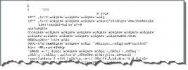
The log is a plain .TXT file & can be opened with Wordpad for instance ... but as it's encrypted nothing can be read out of it in that way.

Opened in Wordpad:

1621237446900.png
In order to get the log decrypted you need to use various web-services like Aidata.com or PhantomHelp.com or computer programs ... all have in the past had the ability to decrypt the .TXT log.

From DJI Fly app v1.22 the encryption was changed ... so today it's only Airdata.com that can decrypt logs coming from higher versions of the Fly app.

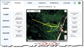
Here the .TXT log uploaded to Airdata.com:

1621237840655.png
You can stop here & use the various Airdata views that's provided ... but as I prefer to depict the important data in graph-form I use a computer program called CsvView (can be downloaded for free here --> CsvView Downloads ) ... usually you could feed in the .TXT log directly there, as the program had the decryption key built in, but now with the newer versions of the Fly app you instead need to download the Airdata .CSV file (red circled above) & feed in that into the CsvView program. That creates the chart you saw in my previous post.

Instead of depicting the .CSV in a chart (with CsvView) you can use Excel & show the data in columns instead ...

Here the same in Excel:

1621238628267.png

The sat pic I included in my post also comes from Airdata.com ... it's the downloaded .KML file (red circled above) opened in Google Earth.

In general ... the above described ways of decrypt logs coming from a DJI Fly app from v1.22 & above doesn't show the whole content of the original .TXT log. This due to that everything needs to go through Airdata.com which cut off a lot of information ... but it's better than nothing.

Recommend you to read up about flight logs here --> Mavic Flight Log Retrieval and Analysis Guide
 
Last edited:
  • Like
Reactions: MA2 317
Lycus Tech Mavic Air 3 Case

DJI Drone Deals

New Threads

Forum statistics

Threads
130,411
Messages
1,552,347
Members
159,418
Latest member
jamoke