DJI Mavic, Air and Mini Drones
Friendly, Helpful & Knowledgeable Community
Join Us Now

Mapping for Air 2S

Solsearcher

Well-Known Member
Joined
Jun 21, 2021
Messages
150
Reactions
268
Location
Winnipeg, Canada
Hi all,

I have a potential client that is looking to get drone footage (pics) of a river that is flooding, in various locations. I must be able to have GPS coordinates "attached", (for lack of a better word) to them. I was initially looking at DroneDeply as a possibility until I see that it isn't working with the Air 2S yet. Then I looked at DroneLInk. I'm not sure either of these are what I'm looking for???
Can anyone offer any suggestions? In an ideal world I can tell the drone where to fly and photograph, and the pics and data would be fairly easy to discern.

If neither of these make sense, please tell me. I have an Android phone, and powerful Winblows computer.

Thanks!
 
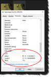
All pics you take with your drone will have the GPS position in the EXIF info ... in windows it's enough to just right click a jpeg, chose properties / information & scroll down a bit there for the GPS position.

1652121262327.png
 
  • Like
Reactions: Solsearcher
Thank you!!
lol....Too hard! j/k. Interesting! I've (obviously) never looked at individual pics to see the properties!
Ok, so that was easy, now what about "pre-programming" a flight path as if you were making a map? Any suggestions with that?
 
Last edited:
You may do a lot better (for mapping) with DroneDeploy and an aircraft that supports waypoints. Otherwise Litchi can be very flexible and a potential solution, but I believe that works better with a “waypoints” drone. Some good deals on M2 Pros out there.
 
  • Like
Reactions: Solsearcher
You may do a lot better (for mapping) with DroneDeploy and an aircraft that supports waypoints. Otherwise Litchi can be very flexible and a potential solution, but I believe that works better with a “waypoints” drone. Some good deals on M2 Pros out there.
Can't afford another drone just yet, so "stuck" with trying to make what I have work. ;)
 
Can't afford another drone just yet, so "stuck" with trying to make what I have work. ;)
To properly carry out mapping missions, you need a drone that supports waypoint operation.
You have to fly a precise grid and capture a large number of images with 75% (or more) overlaps.
You just can't do that manually.

Here are some screenshot examples from a small mapping job:
Here the mission is underway and you can see the precise grid to be flown.
Screenshot_20181111-112140-L.jpg


This is a plot showing the centres of the 84 images captured for a 13 acre site.
T5-L.jpg

For bigger sites, you end up with several hundred images.
 

DJI Drone Deals

New Threads

Forum statistics

Threads
134,578
Messages
1,596,454
Members
163,079
Latest member
jhgfdhjrye
Want to Remove this Ad? Simply login or create a free account