DJI Mavic, Air and Mini Drones
Friendly, Helpful & Knowledgeable Community
Join Us Now

Mavic 4 Pro First Survey Use

Dogpilot

Well-Known Member
Joined
May 11, 2019
Messages
409
Reactions
391
Location
Flagstaff, Arizona
After a few false starts I finally got large waypoint grid surveys working on the Mavic 4 Pro. Litchi has a beta Hub that can output files you can put on the RC-2 Pro. Still Beta and it does have a few errors that crop up. The M4P is a bit tricky on resuming waypoint flights after battery change. Still I could get a 950 waypoint mission done with three batteries at 7 mph over 18 km. This was slightly amazing, since it was also lugging a survey IR camera on its belly and its GPS receiver on top. Should be able to do this easier as I work out the workflow a bit smoother. While not RTK precision, not at all bad, especially if I drop some fiducial marks on surveyed points.
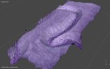
Visible, 950 images
Diablo Trap Plataeu.jpg

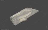
3 Band IR 560 Images

Diablo Trap Plataeu IR.jpg

Mavic 4 Pro with Survey Camera mounted
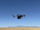
Survery In FLight.jpg
 
Matrice 4T is best DJI drone for this type of work.
Great complement to the Mavic 4 Pro!
IMG_6256.jpeg
 
Wow! Thats a great use of Mavic 4 Pro.
 
  • Like
Reactions: GadgetGuy
Of course a Matrice would be better. I sold off my enterprise drones, both the 3T and 3E. Problem is they can only do their one job, not much else. I would still need to strap the survey camera on it, since DJI's multispectral is pretty much an agricultural tool, not geological. I can select which bands I want to survey this way, what frequencies I want to cut out. I really don't need RTK accuracy for what I do. It would be just one more drone. Another case, more batteries another controller (albeit the controller is awesome). I was also disappointed with the software for the 3T & 4T, it had issues that made it only marginal for my purposes.

I can do both my research with the 4 Pro and shoot my videos for fun that I like to do. All with one drone. Using an external camera makes very adaptable for multiple uses. Besides I use the same camera on the actual airplane as well, so I am working with similar data sets.

Not for everybody, but you can do more things with the drone than most know about. I had a similar strap on mod on my 3 Cine as well. I never did it to the 3 Pro Cine, as it was a little too heavy. The gimbal moved around too much with the strap on load. The 4 Pro gimbal does move quite a bit, a few frames get a shot of the tip of the gear leg as it corners. There are counterbalance weights on the skid tips as well to keep the CG in a reasonable position.
Cool! Clever solutions by adding multiple attachments to one very capable drone. I've been trying to justify buying a Matrice 4T, to complement my Mavic 4 Pro. It has so many additional capabilities, with the huge controller screen, simultaneous use of the enhanced thermal camera with the wide angle and telephoto cameras, laser measurement, built-in RTK, an IR cut filter, dehaze, able to read license plates day or night from insane distances, and usable 128x dynamic zoom to surveil and follow from a distance! Still can’t quite get over the $7900 cost, though, which includes 4 batteries and the gimbal-following spot light! Perfect for LEO, SAR, and wildlife detection and surveillance. Cops could have used one last night! Instead, they noisily circled overhead 3 blocks way for half an hour at 1 AM with a helicopter and a megaphone trying to get some armed guy to come out of a canyon and surrender! Could have paid for a Matrice 4T instead, with the wasted fuel and manpower the helicopter required, while not keeping the entire neighborhood awake!
 
It has some impressive features for sure. I just do not need to track down miscreants. DJI's implementation of thermal software and options for the use of the thermal data is very limiting. For doing what you mentioned, it is great. Using it for research is a disappointment. It is a very tightly controlled and expensive sandbox. Then there is the general shift away from DJI products in mining. Having units that are not DJI is kind of a plus of geotechnical work. The IR work I do is not thermal, I work just above that range. I had a project that could use thermal, but it was a bust, again due to DJI's software.
 
  • Like
Reactions: GadgetGuy

DJI Drone Deals

Forum statistics

Threads
138,813
Messages
1,641,428
Members
167,196
Latest member
fausto.salomao
Want to Remove this Ad? Simply login or create a free account