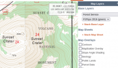
Something I have started doing is looking at increasing my max altitude based on the terrain. To do this, I've been using the Terrain layer of Google Maps to determine the elevation changes and measuring the distance to them. For instance, behind my house, if I fly 300m out toward the mountain, the elevation is 200ft (~60m) higher than my takeoff point, so there I can increase my altitude by 60m to 180m. If I fly an additional 200m out, the terrain is another 60m higher. And so on.
I noticed at another area that I fly there is a mountain that I can use to gain elevation also.
What do you folks do in this situation? Is there an better/easier way to determine this and map it out?
I tried looking at a sectional chart but they are SO busy with airport data and such that it is near impossible to determine specific elevation changes in a small area.
Last edited: