- Joined
- Apr 1, 2019
- Messages
- 71
- Reactions
- 81
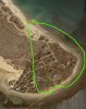
I have more newbie questions about a mission I’d like to fly in Litchi with my Mavic 2 pro. This is somewhat related to the “Litchi Mavic pro waypoint altitude relative to ground” thread but also about connectivity with the controller. The image below roughly depicts the mission I want to fly. It begins with path across land is using “relative to ground” & in this area the cellular service is spotty at best, internet connectivity isn’t always guaranteed. Is this cause for concern?

The second half of the mission (the flight home) I wanted to fly around the around the contour of the ocean side cliff (the red arrows above). This would put the drone out of my sight for about 30 seconds before it turns the corner. At that point in the mission it would be appox. 1500ft away and would descend to about 50ft behind the cliff, then run the contour back around the corner to me . So I guess my question here is so I need to worry about connectivity to the remote in that scenario? I guess I will figure out all these things in time.
I’m not artist but this sort of shows the path.

Trying not to make expensive mistakes but I guess I will figure all these things out in time.
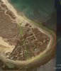
The second half of the mission (the flight home) I wanted to fly around the around the contour of the ocean side cliff (the red arrows above). This would put the drone out of my sight for about 30 seconds before it turns the corner. At that point in the mission it would be appox. 1500ft away and would descend to about 50ft behind the cliff, then run the contour back around the corner to me . So I guess my question here is so I need to worry about connectivity to the remote in that scenario? I guess I will figure out all these things in time.
I’m not artist but this sort of shows the path.
Trying not to make expensive mistakes but I guess I will figure all these things out in time.