

You are using an out of date browser. It may not display this or other websites correctly.
You should upgrade or use an alternative browser.
You should upgrade or use an alternative browser.
My shot of a rather famous bridge...
- Thread starter Hauptmann
- Start date


D
Deleted member 94307
Guest
Thats awesome... At a students home I always see a framed picture on their wall, exactly like yours but from the ground with a shot of a ship going under.. I always think how cool it would be to take the same shot with a drone... NICE
Air_Joe
Well-Known Member
- Joined
- Feb 26, 2019
- Messages
- 304
- Reactions
- 175
Is this the bridge Caesar brought his fellow ape mates to cross back to forest home? [emoji28]
Nice picture, thks for sharing [emoji1360]
Nice picture, thks for sharing [emoji1360]

Aspiring Pilot
New Member
- Joined
- May 14, 2019
- Messages
- 4
- Reactions
- 1
Great shot, out of interest what were your settings for this shot.
skyCoyote
Member
HapK
Well-Known Member
Great job. Nice picture. Where did you launch from?
FlySafeUAS
Member
- Joined
- Feb 7, 2018
- Messages
- 11
- Reactions
- 17
- Age
- 79
I've tried to plan how to take this photo. Checking with AirMap, it looks like this is in restricted air space from one or more of these national parks - Fort Point, Golden Gate or Presideo of SF. What's the secret?
I don't see any controlled air space around the bridge. It is inside a 5 mile radius of an airport, but that's dated. The park boundaries extend off shore but don't include the bridge. One could launch from the bridge, but that probably has it's own restriction. The park restricts taking off or landing of aircraft, it can't restrict flyover. That may not even be possible for suas. You could launch from a boat or you could get permission from the Park Department.I've tried to plan how to take this photo. Checking with AirMap, it looks like this is in restricted air space from one or more of these national parks - Fort Point, Golden Gate or Presideo of SF. What's the secret?
Just say'n, it's possible.
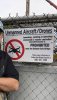
CITY AND COUNTY OF SAN FRANCISCO
MUNICIPAL CODE
SEC. 3.09. AIRPLANES, HELICOPTERS,
HOT AIR BALLOONS, ETC. PROHIBITED.
No person shall launch nor land any air-
plane, helicopter, parachute, hang glider, hot air
balloon, nor any other machine or apparatus of
aviation in any park, nor shall any person bring
into any park any balloon with a diameter of
more than six feet or a gas capacity of more than
115 cubic feet, without permission of the Recre-
ation and Park Department. This Section shall
not be applicable to a helicopter being used to
transport persons or supplies because of an emer-
gency situation. (Added by Ord. 603-81, App.
12/18/81)
Eye in the Sky Studios
New Member
Hauptmann,
What's the scoop? I'm heading to SF in August and would love to know if this was difficult to pull off and/or what location you took off from. Thanks!
What's the scoop? I'm heading to SF in August and would love to know if this was difficult to pull off and/or what location you took off from. Thanks!
I got a pleasant surprise when I returned from a long weekend away. All those replies and LIKES! Thanks to all of you for your interest.
Eye-in-the-Sky, the shot was easy and done legally. I didn't think we could fly OVER the bridge, or we would have. It may actually be legal to do so since all people below are in cars. In any case, I'd rather keep a low profile and do only what I know is legal. Asking someone might invite further restrictions. Please, guys, don't screw it up. We took off/landed from just behind the Palace of Fine Arts--the closest legal point. It's a long flight, but there are places to post observers to stay within VLOS. We fly as a group, so we observe for each other. Check AirMap, and you'll see the PFA and all the restricted airspace around the area (both ends of the bridge, Fort Point, The Presidio, and ALL of the south end of Marin County). Even much the SF Pacific Coast is a no-no because the GGNRA extends almost down to Daly City.
We've flown it a few times. This particular shot was with my Mavic Pro, which didn't leave much battery time near the target. We've since flown it with my new M2P, which offers slightly longer fly-time. My son now has my old MP1. He works in SF and is part of the group. He has flown it also, and got some great shots from the East side of the bridge, but facing SW.
Sorry, Aspiring Pilot, I didn't write down the settings. I was fairly new at flying then, so I'm sure exposure was "auto". I think I used an ND filter (probably an ND8).
BTW, Eye-in-the Sky, AirMap used to show the Transamerica Tower (pyramid) as off-limits, presumably because of an on-site power plant (?). Anyway, it's now shown as legal. We got some shots looking straight down on it, which I'll post later. Be sure to plan your visit so you can fly when the SF Giants are not playing home games--they make most of the city a huge TFR.
Gord, thanks for giving me a great idea. Next time I'm out, I think we'll hang out behind the PFA and wait for a ship to approach the bridge. Then we're OFF!
I hope I've answered everyone's questions.
Thanks again, guys!
Hauptmann
Eye in the Sky Studios
New Member
I got a pleasant surprise when I returned from a long weekend away. All those replies and LIKES! Thanks to all of you for your interest.
Eye-in-the-Sky, the shot was easy and done legally. I didn't think we could fly OVER the bridge, or we would have. It may actually be legal to do so since all people below are in cars. In any case, I'd rather keep a low profile and do only what I know is legal. Asking someone might invite further restrictions. Please, guys, don't screw it up. We took off/landed from just behind the Palace of Fine Arts--the closest legal point. It's a long flight, but there are places to post observers to stay within VLOS. We fly as a group, so we observe for each other. Check AirMap, and you'll see the PFA and all the restricted airspace around the area (both ends of the bridge, Fort Point, The Presidio, and ALL of the south end of Marin County). Even much the SF Pacific Coast is a no-no because the GGNRA extends almost down to Daly City.
We've flown it a few times. This particular shot was with my Mavic Pro, which didn't leave much battery time near the target. We've since flown it with my new M2P, which offers slightly longer fly-time. My son now has my old MP1. He works in SF and is part of the group. He has flown it also, and got some great shots from the East side of the bridge, but facing SW.
Sorry, Aspiring Pilot, I didn't write down the settings. I was fairly new at flying then, so I'm sure exposure was "auto". I think I used an ND filter (probably an ND8).
BTW, Eye-in-the Sky, AirMap used to show the Transamerica Tower (pyramid) as off-limits, presumably because of an on-site power plant (?). Anyway, it's now shown as legal. We got some shots looking straight down on it, which I'll post later. Be sure to plan your visit so you can fly when the SF Giants are not playing home games--they make most of the city a huge TFR.
Gord, thanks for giving me a great idea. Next time I'm out, I think we'll hang out behind the PFA and wait for a ship to approach the bridge. Then we're OFF!
I hope I've answered everyone's questions.
Thanks again, guys!
Hauptmann
Thanks so much for the details!
jgullam
Member
New to this and still trying to work out all of the rules, let me see if I've got this right:
It is forbidden to take off or land in a National Park but just fine to fly over one?
Thanks
It is forbidden to take off or land in a National Park but just fine to fly over one?
Thanks
heyengel
Well-Known Member
- Joined
- Jul 14, 2017
- Messages
- 59
- Reactions
- 36
That's my understanding as well, but you STILL are required to maintain VLOS.
According to this FAA document, 'daisy-chaining' visual observers is not allowed unless you have a waiver. Are you sure this is legal?
FAA: Home
 fsims.faa.gov
heyengel
Well-Known Member
- Joined
- Jul 14, 2017
- Messages
- 59
- Reactions
- 36
If not, those who try to set distance records are operating illegally.
That was FAA’s reaction to those people. The FAA is saying it is not allowed. Do you see anywhere in Part 107 that allows this? The uas operator has to maintain VLOS.
Similar threads
- Replies
- 6
- Views
- 644
- Replies
- 4
- Views
- 590
- Replies
- 2
- Views
- 445
- Replies
- 10
- Views
- 2K


DJI Drone Deals
New Threads
-
-
 3 Second attempt to navigate coming clouds
- Started by alex_markov
- Replies: 0
-

-
-
 Air 3 3 Features I Love About New DJI Drones
- Started by VegardBerland
- Replies: 2
Forum statistics
