


You are using an out of date browser. It may not display this or other websites correctly.
You should upgrade or use an alternative browser.
You should upgrade or use an alternative browser.
New Geo Fencing and Zones a complete mess for 107 Pilot
- Thread starter Rick Lohre
- Start date

And how is that accomplished? NLD site app?you can eliminate nfz and altitude from pro 1

John 8 Degree
New Member
- Joined
- Mar 17, 2019
- Messages
- 4
- Reactions
- 0
Autel Ego. ??? I don't see in Google Play App Store. I do see AIRMAP which I find very useful on my iPhone. BUT BUT. these Alps won't I stall on my SMART CONTROLLERFYI. I was able to finally secure unlock for area within KLUK airport area.
They needed a "signed authorized document" so I gave them one.
Thanks for the suggestion. I actually built my first drone way back in 2008 when I had to solder my own circuit boards etc. I'm thinking of trying that again too! LOL. At least I'm in control. I'll research the Autel Evo as I do need a backup since all of my other backups are DJI based. Smart suggestion.
Cheers,
Rick
")
John 8 Degree
New Member
- Joined
- Mar 17, 2019
- Messages
- 4
- Reactions
- 0
Fat fingers. EVO not Ego. APPs not AlpsAutel Ego. ??? I don't see in Google Play App Store. I do see AIRMAP which I find very useful on my iPhone. BUT BUT. these Alps won't I stall on my SMART CONTROLLER
To Thomas B- Still new to the Airmap app. Cannot figure out how to get permission to fly. Have the app installed and looked at it but not sure if I just call a telephone number or activate something on the app. Most of the time I am flying right above my head for still photos- never higher than 100 -200 feet and in the city (like parks where I practice flying) I only fly to the limit of the park grounds which is usually no more than a few blocks.First, welcome to the forum!... there’s a lot of good info here.
Some zones will remain no fly, like the 30 miles presidential visit in Florida. For routine NFZs like airports, etc, I use AirMap for LAANC clearance on my iPhone. It’s instantaneous. I have never been “grounded”.
Check all the other threads on this. They are numerous with a lot of info, how to’s, and explanations.
In the countryside or wilderness areas I do fly longer distances and try to keep in line of sight. So my question is, how do I notify authorities on Airmap app.?
This new DJI zone blocking and unlocking has become a complete and utter cluster-f#$% for me as a 107 pilot with my new Mavic 2 when trying to fly in FAA restricted and even in non FAA restricted zones.
For instance, Downtown Cincinnati, no FAA restriction in the area but there's a HUGE blue circle. I'm prompted to unlock, but must do from a computer!
No PC needed, you can unlock blue zone straight from the DJI GO4 App, it send
a verification code to your mobile device , takes less then 2 min.
Must be a part 107 pilot and select that option on the page for LAANC approval . You can also select 333exrmption or fly for fun as appropriate. The app is evolving now contains contact phone#’s for airports.To Thomas B- Still new to the Airmap app. Cannot figure out how to get permission to fly. Have the app installed and looked at it but not sure if I just call a telephone number or activate something on the app. Most of the time I am flying right above my head for still photos- never higher than 100 -200 feet and in the city (like parks where I practice flying) I only fly to the limit of the park grounds which is usually no more than a few blocks.
In the countryside or wilderness areas I do fly longer distances and try to keep in line of sight. So my question is, how do I notify authorities on Airmap app.?
Last edited:
Sky-Scraper
Member
- Joined
- Aug 22, 2017
- Messages
- 8
- Reactions
- 4
- Age
- 71
You're a little confused. The Autel Ego is a drone, not an app. AIRMAP is an app for your phone, not your controller.Autel Ego. ??? I don't see in Google Play App Store. I do see AIRMAP which I find very useful on my iPhone. BUT BUT. these Alps won't I stall on my SMART CONTROLLER
AngelAndres
Member
- Joined
- Oct 14, 2018
- Messages
- 13
- Reactions
- 8
- Age
- 46
This has basically rendered my drone USELESS for business purposes. As a licensed 107 pilot who flies multiple missions a week, to have to unlock TFR's that are improperly put into place and stacked (READ: MLB games stacked one on top of each other in perpetuity in Cincinnati, OH) and for the unlock to only last 3 days, I have had to turn down thousands of dollars in missions in this area due to the last minute nature of the jobs to guys who are running outside of the system using either non geofenced drones or drones which circumvent the restrictions via illegal apps and hacks!!
Sucks to pay attention and follow the rules and only be shut down because of it.
Add to all of that, DJI does not approve more than 75% of the time because they require "documentation" which in the US, we do not have or need for TFR's that aren't actually active!!!! SMH
Hi Rick,
I am completely on board with your problems as well.
I run an 8-pilot, 10 DJI-aircraft operation for a news station in Denver, CO. One of our missions is to provide aerial footage in support of the breaking news operations of the station. This mission, as you can imagine, often allows us little notice. Such notice is often less than 2 hours and is much less than the "up to 5 days" that DJI advises can take them to unlock an "NFZ".
In practice, we've recently been blocked by an improperly drawn DJI NFZ (note, I wrote "NFZ", not "GeoFence" which is much easier to unlock via DJI's app) near the Denver Centennial airport. Our pilot was unable to complete their mission because the operation area fell within the improperly drawn DJI "GeoFence" and "NFZ" zone. The motors wouldn't even start. We've reached out to DJI's legal, marketing, media and sales departments in search of a reasonable solution for the operation and so far we've received only one reply from their marketing department with an unexplained refusal to assist us in the matter.
Every one of our pilots are Part 107 Certificated. We have in-house training above and beyond the Part 107 training. We also use the LAANC waiver system to provide us access to airspace near our local Class D airports. In addition, we have a relationship with local helicopter operators and establish communication with them prior to our operations near Heli pads. We are a legal, proficient and safe operation unable to do our jobs because of DJI.
We've begun to explore other aircraft platforms, such as Autel and Yuneec in hopes of finally ridding us of this mess.
Rick, I write all this in hopes that you find yourself in good company and feel supported by people who have gone through the same thing.
Sincerely,
Angel
The strangest part, beyond the completely unique maps of DJI designated NFZs map, is the fact that DJI is not an FAA approved authority for LAANC clearance under FAA regs. See the list about half way down the page linked below:Hi Rick,
I am completely on board with your problems as well.
I run an 8-pilot, 10 DJI-aircraft operation for a news station in Denver, CO. One of our missions is to provide aerial footage in support of the breaking news operations of the station. This mission, as you can imagine, often allows us little notice. Such notice is often less than 2 hours and is much less than the "up to 5 days" that DJI advises can take them to unlock an "NFZ".
In practice, we've recently been blocked by an improperly drawn DJI NFZ (note, I wrote "NFZ", not "GeoFence" which is much easier to unlock via DJI's app) near the Denver Centennial airport. Our pilot was unable to complete their mission because the operation area fell within the improperly drawn DJI "GeoFence" and "NFZ" zone. The motors wouldn't even start. We've reached out to DJI's legal, marketing, media and sales departments in search of a reasonable solution for the operation and so far we've received only one reply from their marketing department with an unexplained refusal to assist us in the matter.
Every one of our pilots are Part 107 Certificated. We have in-house training above and beyond the Part 107 training. We also use the LAANC waiver system to provide us access to airspace near our local Class D airports. In addition, we have a relationship with local helicopter operators and establish communication with them prior to our operations near Heli pads. We are a legal, proficient and safe operation unable to do our jobs because of DJI.
We've begun to explore other aircraft platforms, such as Autel and Yuneec in hopes of finally ridding us of this mess.
Rick, I write all this in hopes that you find yourself in good company and feel supported by people who have gone through the same thing.
Sincerely,
Angel
UAS Data Exchange (LAANC)
 www.faa.gov
It is also of note that real-time authorization to fly can be obtained in seconds through use of approved apps on the list referenced above.
This eliminates the DJI restrictions. I use AirMap successfully 100% of the time. I never ask DJI for clearance.
Better than potential illegal activity that would likely generalize even more onerous regulation on both professional and hobbyist pilots.
Blame it all on a drunk State Department employee who decided to take his DJI Phantom for a cruise at 3am and then crashed into a tree on the White House lawn.
Airmap...hmmm hadn't really thought much about that. Went out and flew using it for the first time on this drone and seemed flawless with full access to drone's capabilities that I need. Will go to one of the "zones" that DJI has imposed and report back.The strangest part, beyond the completely unique maps of DJI designated NFZs map, is the fact that DJI is not an FAA approved authority for LAANC clearance under FAA regs. See the list about half way down the page linked below:
My understanding is that this applies to all 107 pilots regardless of aircraft manufacturer.UAS Data Exchange (LAANC)
It is also of note that real-time authorization to fly can be obtained in seconds through use of approved apps on the list referenced above.
This eliminates the DJI restrictions. I use AirMap successfully 100% of the time. I never ask DJI for clearance.
Better than potential illegal activity that would likely generalize even more onerous regulation on both professional and hobbyist pilots.
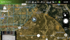
Screenshot shows FAA recognized areas but not the DJI craziness...so maybe there's a chance. Unless it's coded into the drone's GPS.
Attachments
Taffybrian
Member
- Joined
- Dec 19, 2017
- Messages
- 18
- Reactions
- 8
- Age
- 82
I have actually bought the Evo as DJI put me in same position as others. I am 107 licensed - incidently just passed the recurrent test last week. Have been with clients and unable to take off in area where authorisation is not required. I felt a complete prat. Eventually I had to buy another dron to catch up with work. But if anyone thinks of the Autel it flies great probably better than Mavic, but camera is fixed focus and stills are barely useable, but video really nice. (DJI Go - I was unable to take off anywhere the App showed everywhere as NFZ)
Similar threads
- Replies
- 20
- Views
- 3K
- Replies
- 9
- Views
- 3K
- Replies
- 15
- Views
- 5K
- Replies
- 2
- Views
- 2K


DJI Drone Deals
New Threads
-

-

-
-

-
 3 One of most extreme flights I made for now
- Started by alex_markov
- Replies: 3
Forum statistics
