DJI Mavic, Air and Mini Drones
Friendly, Helpful & Knowledgeable Community
Join Us Now

Air 2s New Presque Isle Lighthouse - With some rendering

karlblessing

Gerbil Charmer Extraordinaire
Premium Pilot
Joined
Oct 17, 2020
Messages
1,213
Reactions
893
Age
43
Location
Grand Rapids, MI
Site
karlblessing.com
Had a really busy week so far driving all around the state getting stores done, along with the severe thunderstorms that were happening.

Managed to stop by the New Presque Isle Lighthouse a bit north of Alpena, Mi before some weather came thru (and before the 45mph+ gusts started kicking in more often) to get a little mapping done.

628 frames captured on my Air 2S. This being one of the frames :
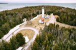
DJI_0445.jpg

The rendering output from WebODM with camera positions shown
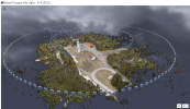
Screenshot 2023-04-06 204736.png

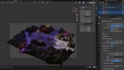
A still out of Blender when I played around with it in there.
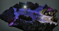
blender.jpg

And then a video rendering of that.

 
That is fantastic! Can you point me to where I can learn to do that? Were you able to shoot all of that in one flight with your 2S?
 
That is fantastic! Can you point me to where I can learn to do that? Were you able to shoot all of that in one flight with your 2S?
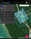
It was two flights, one for the mapping pointing the camera straight down with 85% overlap in a grid, and the other was a couple of orbits (mainly centered around the little red building with one more after the mission around the lighthouse at a slightly higher altitude).

Screenshot_20230406_230105_Airdata UAV.jpg

Screenshot_20230406_230312_Dronelink.jpg

Helps that you can pause it, land it and change battery, and resume where you left off.

Then took all those photos and put them into WebODM and waited a few hours for it render the final data.

Imported the obj file from that into Blender and did some modifications of the mesh to make an empty space at the top of the lighthouse and thew some lights in and rendered a short video clip with the camera animating on a path.

Screenshot_20230406_230658_Messenger.jpg
 
  • Like
Reactions: WanderLost
Excellent! Thanks so much for your detailed reply - now I have some homework to do. I have a few quarries near me that would look great in 3D.
 
Excellent! Thanks so much for your detailed reply - now I have some homework to do. I have a few quarries near me that would look great in 3D.
Depending on the drone, the key seems to make sure its in good focus and do slower flights to improve on the clarity, since apps like dronelink (short of an Enterprise plan), snaps the pictures without ever stopping the drone. Can also use the facade mode to capture the face of surfaces as opposed to doing multiple orbits.

The more images you have the better the features can be especially if it's a nice overcast day with no change in shadows.
 
  • Like
Reactions: WanderLost
Depending on the drone, the key seems to make sure its in good focus and do slower flights to improve on the clarity, since apps like dronelink (short of an Enterprise plan), snaps the pictures without ever stopping the drone. Can also use the facade mode to capture the face of surfaces as opposed to doing multiple orbits.

The more images you have the better the features can be especially if it's a nice overcast day with no change in shadows.
Unfortunately, I have a Mavic 3. But I think I can still make it work if I fly slow and have it take shots every 1 second for example with lots of overlap. I've done vaguely similar stuff in Photoshop making orbits and backyard planets for example.
 
Nice work
 
Lycus Tech Mavic Air 3 Case

DJI Drone Deals

New Threads

Members online

Forum statistics

Threads
131,129
Messages
1,560,125
Members
160,100
Latest member
PilotOne