On account of the excellent help I got from a Kiwi fellow UAS user, via PM, some time ago, in the first stages of preparing a trip to New Zealand, I become aware of the existence of the Air Share app.
The previous help seems unable to provide further assistance, so I am turning to a more general audience in hope that another new zealander user of this particular app might be able to provide further insights.
...I've toyed a bit with it but still seem to be at odds with the color labels in the app.
For instance, they mention "Low flying" zones being colored orange but I can't discern yellow from orange in the app.
Also, the blue used for "aerodromes" seems to be the same as the one used for "No fly zones".
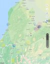
Let's see if I got it straight, from this sample:

1. There are large light yellow circles that, by the labeling, should pertain to "Danger Areas" but they seem to rather pertain to active NOTAMS, being that one relates to a simple A/G frequency being inoperative. Why would that constitute a "Danger Area"? If they don't relate to the NOTAMS, what are they, this big?
2. The blue areas over, for instance, Collingwood, Karamea and Murchinson relate to "No Fly Zones", not "Aerodromes", correct? If so, although the app states that the "No Fly Zones" are areas where we are unlikely to receive approval to fly in, we can still try to obtain authorization from the administrating authority or land owner, correct?
3. The yellow polygons, as the ones north of St. Arnaud and over Stockton, relate to "Danger Areas"? If so, does the wording "These areas are where an activity within is a potential danger to aircraft flying over that area" mean that operations under part 101 are still allowed for a drone featuring "Air Sense", if due care is taken?
Thank you in advance for any help with this matter.
The previous help seems unable to provide further assistance, so I am turning to a more general audience in hope that another new zealander user of this particular app might be able to provide further insights.
...I've toyed a bit with it but still seem to be at odds with the color labels in the app.
For instance, they mention "Low flying" zones being colored orange but I can't discern yellow from orange in the app.
Also, the blue used for "aerodromes" seems to be the same as the one used for "No fly zones".
Let's see if I got it straight, from this sample:
1. There are large light yellow circles that, by the labeling, should pertain to "Danger Areas" but they seem to rather pertain to active NOTAMS, being that one relates to a simple A/G frequency being inoperative. Why would that constitute a "Danger Area"? If they don't relate to the NOTAMS, what are they, this big?
2. The blue areas over, for instance, Collingwood, Karamea and Murchinson relate to "No Fly Zones", not "Aerodromes", correct? If so, although the app states that the "No Fly Zones" are areas where we are unlikely to receive approval to fly in, we can still try to obtain authorization from the administrating authority or land owner, correct?
3. The yellow polygons, as the ones north of St. Arnaud and over Stockton, relate to "Danger Areas"? If so, does the wording "These areas are where an activity within is a potential danger to aircraft flying over that area" mean that operations under part 101 are still allowed for a drone featuring "Air Sense", if due care is taken?
Thank you in advance for any help with this matter.


