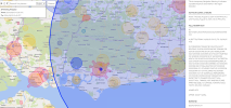
Just been doing 'pre-flights' for a planned all-day flight / ride mission on Thursday down in Southsea, and I see another vast blue bubble has appeared on DroneSafetyMap, this time covering almost the entire South East of the country from Hastings to Portsmouth for a Formation transit !

I know it's only for an hour or so, but my god that is a huuge area of the country to cover !!
Last time there was one of these it went from blue (advance notice) to Yellow (warning but not FRZ) on the day, but my question is: Is there any way to tell in advance whether it's going to be a warning zone or a flight restriction one (without calling that number - don't want to waste their time with my 'amateur' questions !!). Am I right to presume that the use of the text 'Navigation Warning' means it will go yellow ? And that if that is the case I should be extra vigilant flying then, if I am, but it shouldn't actually prevent me from doing so ?
Last edited:


