Is there a way to download Air Control maps to your phone for offline use if you're in the outside of cell coverage when you're flying?
You are using an out of date browser. It may not display this or other websites correctly.
You should upgrade or use an alternative browser.
You should upgrade or use an alternative browser.
Offline maps in Air Control?
- Thread starter aframe9999
- Start date
LoudThunder
Part 107 Licensed
If you are out of cell phone coverage, where are you flying that you would need to use Air Control and it's LAANC Authorizatiuons? It's not the same, but you can preload the maps into your controller before you go flying if you know here you are going...
Not so much for LAANC authorization. But things like designated wilderness areas, boundaries to national parks, TFRs and other places that would be off limits to drones.
I’ll look into downloading to the controller. Didn’t know that was a thing. Thx
I’ll look into downloading to the controller. Didn’t know that was a thing. Thx
LoudThunder
Part 107 Licensed
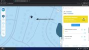
Like I wrote earlier, if you know where you are going to fly, and if you have a computer, use the B4UFly App and scroll over to where you intend to fly. Using a phone is very difficult as the screen is so small… On the PC, you can zoom in so much that you will see the street names and even the outlines of structures as in this sample that shows the detail of my home…But things like designated wilderness areas, boundaries to national parks, TFRs and other places that would be off limits to drones.

Similar threads
- Replies
- 7
- Views
- 768
- Replies
- 1
- Views
- 742
Share:
DJI Drone Deals
New Threads
-
Air 3s Video settings tested - D-Log vs. HLG
- Started by DroneZone Samui
- Replies: 0
-
-
Mavic 3 classic purchased in the USA, on CE transmission profile?
- Started by Ossbourne
- Replies: 0
-
-


