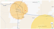
For anyone close to that area, would anyone be able to tell me what NFZ might interfere with a potential flight I have going on? Or post a screenshot of the airspace around the airport. I have attached a screenshot of my own with a red dot showing the approximate area I may be flying. I know that DJI's online map exists but it isn't showing me NFZ's around the airport like one might see if they were physically near there and looking at the map that displays in the app while you're flying. It doesn't seem like there would be an NFZ on that spot but I have to make sure before I make the trip out there. I'd hate to go and not be able to do anything.
Any help is lovely, thanks in advance.
Any help is lovely, thanks in advance.