DJI Mavic, Air and Mini Drones
Friendly, Helpful & Knowledgeable Community
Join Us Now

Read this NFZ!!

Natehighup

Well-Known Member
Joined
May 22, 2018
Messages
58
Reactions
16
Age
43
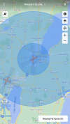
67979D00-E9C7-4995-AEF1-CDE86857AC47.pngWas going for a flight and at 9200 feet I was (I have eagle vision for vlos before anyone states the obvious ?) and this message pops up and the drone stops! Like it hit a wall, said restricted zone land immediately! I could not return to home auto or manually, could unlock nothing! This zone on the map wasn’t up when I took off, I had to let the drone land in a field and go get it, btw the find my drone feature is very accurate and I had enough power too see the camera feed and hear the beeps when I got close. Is there such a thing as temporary restrictions that just pop up? The circle by the green bay airport is always there albeit much smaller but I’m on the outer edge of the big circle that has never been there. Just something for you filks to be aware of if you don’t know,thought I would share.
 
Expect more of the same until after the election.
 
  • Like
Reactions: zocalo and Thomas B
No fly zones (restricted air space) around airports can look like upside cones. As you get higher, the no fly zone gets bigger. Actually, it's more like an upside down wedding cake with steps instead of smooth sides. Close to the ground, you can fly near an airport since no planes skim the ground. But in the air, you need to stay further away. Maybe your altitude brought you into the no fly zone that was already there.
 
No fly zones (restricted air space) around airports can look like upside cones. As you get higher, the no fly zone gets bigger. Actually, it's more like an upside down wedding cake with steps instead of smooth sides. Close to the ground, you can fly near an airport since no planes skim the ground. But in the air, you need to stay further away. Maybe your altitude brought you into the no fly zone that was already there.
Altitude does have restrictions based on distance.., but it is possible to get FAA clearance which may be altitude limited if you’re not getting into the approach and departure paths.
 
  • Like
Reactions: Hauptmann
Were you in one of those blue circles? If so, those aren’t temporary flight restricted areas, those are no fly zones and aren’t temporary but permanent. That airport, KGRB, is a class c airport, and nobody can fly a drone in the inner circle at all without prior approval. The outer circle doesn’t start until 1900’ and is restricted from 1900’ to 4700’. So someone could fly in the outer blue circle from the ground up to 1899’.
As of right now, there aren’t any TFRs in that area.
 
If you use something like AirMap, those circles will be broken down into grids with numbers in them. Usually the dead center being 0 (no flying at all), and then 100, 200, 400 feet and so on, showing the # that automatic authorization is usually given at below those altitudes. And can tap on a specific grid for further information. Technically B4UFly and Kittyhawk should give the same info if you pin a specific spot, just without a visual of the grid break down.

It's like Maintenance guy said, it's like an upside down wedding cake, with the altitude restriction getting greater the closer to the airport it is, which makes sense how low the planes have to get as they make a landing approach, or take off.
 
Expect more of the same until after the election.

That would be my guess too. Not following the US elections *that* closely, but my immediate guess was that someone important flew into Green Bay on the campaign trail leading to the much larger NFZ being added to the usual small ones on the map for the duration. Google says President Trump was there on Friday, so that would definitely explain it!

NOTAMs should give you advance notice of these to prevent you getting caught out, so I'd definitely make sure you have an app that includes information on these. Might only be a few days, or even hours, in the case of things like this, but as long as the NOTAM it in place before you take off that should be good enough.
 
  • Like
Reactions: Hauptmann
DJI put a blue zone around a fire TFR near me. I knew I was clear of the TFR as I have foreflight and I received a authorization to fly in the blue area. While flying and still 3 miles or so from the TFR I would get a warning that I was near a restricted zone and that the drone would land if I violated that airspace. The TFR doesn't show on the DJI map.
Getting an account with 1800wxbrief.com might be a good Idea for drone pilots.
 
  • Like
Reactions: xi-elf
Here was the TFR/NOTAM that you ran into. Temporary flight restrictions for VIP Movement. No UAS operations were authorized in the areas covered by the NOTAM.

Area A
Airspace Definition:
Center: On the GREEN BAY VORTAC (GRB) 145 degree radial at 5.1 nautical miles. (Latitude: 44º29'05"N, Longitude: 88º07'47"W)
Radius: 30 nautical miles
Altitude: From the surface up to and including 17999 feet MSL
Effective Date(s):
From October 30, 2020 at 1845 UTC (October 30, 2020 at 1345 CDT)
To October 30, 2020 at 2315 UTC (October 30, 2020 at 1815 CDT)
Area B
Airspace Definition:
Center: On the GREEN BAY VORTAC (GRB) 145 degree radial at 5.1 nautical miles. (Latitude: 44º29'05"N, Longitude: 88º07'47"W)
Radius: 10 nautical miles
Altitude: From the surface up to and including 17999 feet MSL
Effective Date(s):
From October 30, 2020 at 1845 UTC (October 30, 2020 at 1345 CDT)
To October 30, 2020 at 2315 UTC (October 30, 2020 at 1815 CDT)
 
  • Like
Reactions: Hauptmann
View attachment 116145Was going for a flight and at 9200 feet I was (I have eagle vision for vlos before anyone states the obvious ?) and this message pops up and the drone stops! Like it hit a wall, said restricted zone land immediately! I could not return to home auto or manually, could unlock nothing! This zone on the map wasn’t up when I took off, I had to let the drone land in a field and go get it, btw the find my drone feature is very accurate and I had enough power too see the camera feed and hear the beeps when I got close. Is there such a thing as temporary restrictions that just pop up? The circle by the green bay airport is always there albeit much smaller but I’m on the outer edge of the big circle that has never been there. Just something for you filks to be aware of if you don’t know,thought I would share.
 
The President was in that area yesterday, any time the PRES is in an area all Air Traffic is in a NFZ for the duration that the President is in the area
 
DJI put a blue zone around a fire TFR near me. I knew I was clear of the TFR as I have foreflight and I received a authorization to fly in the blue area. While flying and still 3 miles or so from the TFR I would get a warning that I was near a restricted zone and that the drone would land if I violated that airspace. The TFR doesn't show on the DJI map.
Getting an account with 1800wxbrief.com might be a good Idea for drone pilots.
Getting an account with 1800wxbrief.com is a good idea; I think I'll do this myself.

Also, The Sky Vector website is a great website to see NFZs, NOTAMs, TFRs, METARs, and TAFs. It uses actual charts that are updated daily.

 
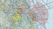
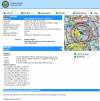
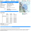
Here is a screen capture around central Florida from Sky Vector. The large airport in the middle is Orlando International Airport. The red circle above it is Sanford International Airport, It currently has a TFR because of an airshow that is happening right now. The large orange TFR to the east is because of an upcoming launch from Cape Canaveral. Clicking on a TFR brings up an explanation of the TFR, the affected areas, the start date/time, ending date/time and the reason why.


Central Florida Sectional Chart:
Capture.PNG


Air show NOTAM:
Capture.PNG


Rocket Launch NOTAM:
Capture.PNG
These are all from SkyVector. As you can see, it is a very powerful free tool on the Internet that provides all of the information that we need to be safe drone operators.

Hope this helps!
 
  • Like
Reactions: Natehighup
Lycus Tech Mavic Air 3 Case

DJI Drone Deals

New Threads

Members online

Forum statistics

Threads
130,597
Messages
1,554,235
Members
159,603
Latest member
refrigasketscanada