For the first time ever, I saw the benefit of having a forward-looking collision sensor-equipped drone. Most of the time I fly my trusty Phantom 3S, launching it on autonomous flights far beyond signal range because it is perfectly legal to do so in my remote Third World location. My drone's usual altitude in this area has always been 150 feet AGL, and I'd never had any issues at that height.
A new airport is being carved out of the jungle a few miles away, and I decided to check it out flying my Mavic Pro, without the benefit of a Litchi flight plan, because I wasn't sure about the exact location of the runway that is being bulldozed. Drove to a secure location about a mile from the site, and flew over the area at 200 feet AGL, returning to base without incident.
With my confidence thus boosted, and the location pinpointed on my Litchi map, I decided to prepare a flight plan that departed from a different location that was about 20 feet lower in elevation than the original launch site. Sent the Mavic on its way, at a lower altitude of 150 feet AGL so as to have a better look at the proposed airport, and soon the bird was out of signal range, presumably flying the waypoint course without a hitch. Twiddling my thumbs I awaited its arrival.
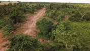
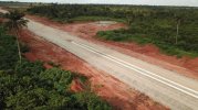
About 22 minutes later, the drone arrived after auto-RTH evidently kicked in, which I found a bit odd, since I'd flown the Mavic on flights of identical duration before, without having RTH taking over. When I reviewed the footage, however, my jaw dropped, because the drone had just barely cleared several treetops, and was clearly NOT flying at 150 feet AGL as programmed. The altitude was more like about 80 feet AGL, which was just a hair above the palm trees.
Finally, as the footage played, the Mavic was on a direct collision course with a tall palm tree right beside the newly bulldozed runway, but then, to my grateful amazement, it slammed on the brakes at the very last instant, swiveled around, and made a beeline for home. That entire sequence of events took place well beyond signal range, and I was none the wiser until I played the footage back.
The purpose of this long dissertation is to recount a new lesson I have learned just today about programming Litchi flights, which is that if the launch site is lower in elevation than the course to be flown, a very generous margin of error must be applied to the altitude, so as to avoid hitting trees or terrain.
I have flown my Phantom3S close to 2,000 miles cumulatively, and never experienced any near misses with trees, yet, I am now absolutely certain that the Phantom would have hit that palm tree and joined its ancestors right there, if I had flown the Phantom and not the Mavic today. Thank goodness for Mavic's obstacle avoidance technology. Here are a few screenshots of the near calamity that taught me this vital lesson about staying at a safe height.


Last edited:


