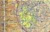
I live a few blocks outside this orange bubble for the local airport. However, this is still within 5 miles of the airport.
My understanding is that I can fly a Mavic outside of that bubble from my home but would need to inform the airport each time I flew.
Here is a screenshot of my location:

My understanding is that I can fly a Mavic outside of that bubble from my home but would need to inform the airport each time I flew.
Here is a screenshot of my location: