


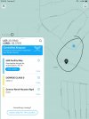
The pic on left shows class d air space where the tear drop is 400ft AGL altitude from ALOFT formally kitty hawk . The pic on the right is from DJI fly shows geo zone , glide path to KCXO Conroe . The scribble is in the glide path same location as the map on ALOFT map from FAA . With a max altitude of 60ft AGL on the DJI fly map .
Before I bought my DJI products , I bought a Hubsan Zino Pro . And was all about the rules and used Kittyhawk for Pre flight plan and got flight authorization for the same area class d air space with 400ft max AGL . When I upgraded and bought my Air 2 DJI fly came into play with the Geo zones and the same area with 60ft AGL restrictions .
When I flew my mini 2 into the same area , was 928ft SSW 328ft altitude no problems flying back to home point . When I flew my Air2 into the same area I got a warning saying I was in a geo zone and was going to force land and RTH might fail . Luckily I took heed and flew back home manually .
So what I’m getting at is even using the B4UFLY map when I had my Zino and was making every attempt to fallow the rules was or could have been in violation . Why are the maps different .
Attachments

Last edited:


