Hey there, and welcome to ...all this

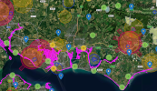
If you look on the internet you will quickly find that there is a LOT more information on where you can't fly than where you can ! And of course we do need to take some notice of that, and the rules set out by CAA. Here is a typical map of my bit of the South East UK, which shows the Flight Restriction Zones (red) and Flight Warning Zones (yellow) that exist all over the country and we
must obey.

Good news is that apart from these Red Zones, you have a Mini 5 Pro, which can fly legally <400 ft above just about anywhere, except over crowds, because it is Class 0 or under 250g. See the various other threads here about whether the Mini5P IS actually under 250g for more detail, but basically it is not the end of the world if yours is over by a gram a 2, as those tend to be.
The safest places to fly, and therefore for comfortable options for people who haven't done much of this before include much of the open countryside, the quieter parks, and areas of outstanding natural beauty, and hills, where you have very good VLOS (visual line of sight) with your craft all around. Being in the UK, you'll see that the National Trust or English Heritage manage most of those sites, and they
hate drones and do their level best to forbid their use on 'their' land, which, for me at least, is one the most frustrating things about the hobby in this country. But worry not, because as long as we don't Take off or land directly from their land we can fly across it legally regardless, so you shouldn't let their unfair anti-drone rulemaking hold you back from filming their open country locations !
The Queen is quite helpful if you do hobby drone flights because she has designated most coastal foreshore areas (shown pink on the map above) 'owned' by the crown as places where she gave permission to fly, and that really does open up vast areas to us, especially along coasts and beaches.
I think the single best piece of advice I can give you is 'Join
Grey Arrows' drone club, and become an insured member there, which will allow you to view all the special layers on the Dronescene map.
Pop over there now, and see what it looks like in your area, which should show you Red and Yellow zones and ever important NOTAMS, but will be lacking the National Trust and foreshore information. So the free version is still enough to work with, but if you join GA the map becomes much more about where you CAN fly rather than where you can't.
Lastly, I'd like to share one of my own recent videos with you, showing a fully legal flight over our biggest country Park here in Hampshire, QECP, which is exactly what sort of flight these machines are optimised for. Slow, gentle sail-planes around local viewpoints taking HQ video and editing it together with a nice soundtrack and maybe some SFX (in my example the wind noise) to give a better sense of location and atmosphere.
I post that because it's quite a good example of a safe and (mostly) lawful flight, (there might be a bit of light trespass in the farmer's launch field, but nothing the CAA cares about !) in a typically suitable sort of area, where there are interesting things to see, and very good all round visibility so we never lose sight of our UAV in the sky

And then you need to learn video editing, something best done, IMO, in Da Vinci Resolve, of which there is a free version ! You can either score and record your own music, as I prefer to do, or there are vast libraries available online of tracks you can license or use for free (although the free ones tend to be of deeply variable quality!). You can search this site for the many existing threads about where to go for music, so I won't bang on about that here.
So much more to say, and so little time, but hopefully that's enough to kick you off in the right direction.
Safe and enjoyable flying, Sir !


