

I'm sure this has been asked before by some other numbnut like me but given VLOS restrictions and few other things, what is the true benefit of flying waypoint "missions"? I used to do it when I played Apache on the Amiga 600 but that was the last time I had any use for it....
You are using an out of date browser. It may not display this or other websites correctly.
You should upgrade or use an alternative browser.
You should upgrade or use an alternative browser.
Why waypoints? What's the attraction?
- Thread starter Thwyllo
- Start date
53-63-6f-74-74
Well-Known Member
1. The ability to pre plan a flight in a 3 dimensional environment (Google Earth) and repeat it with a adjustments if needed. Also the ability to virtually fly it with Namirda's app.
2. The ability to focus on points of interest and perform specific camera actions at each without user input.
3. The ability to make extremely smooth automated maneuvers, pans, elevation changes, gimbal movements, speed changes that are difficult to perform manually.
4. A Litchi mission will complete regardless of RC connectivity giving the ability to fly around terrain or structures that block transmission.
5. A mission may be flown to collect images or video to be used for photogrammetry and the creation of 3d models and orthographic photos, with apps such as Drone Deploy, Drone Harmony, Pix4d, etc.
6. As you have already eluded to, you can fly well beyond VLOS or transmission range.

Ah ok, thanks - that's useful. I can see the technical benefit in your point (5) but it's kind of as I suspected for the rest. Most photographers want absolute control over what they're shooting in terms of height, angles, field of view etc.. and you can't work that out from a map so I can only imagine you have to make the best of what images and video turns up when the drone gets back.
My biggest issue though would be allowing a drone to fly off on autopilot. If a helicopter or low flying
aircraft were to suddenly arrive on the scene, or even a flock of birds, you'd need to be constantly watching the screen if you're any distance away in order to manoeuvre as necessary - and if you have to be constantly watching the screen because of that, I'm not sure I see the point in autopilot?
But that's just me! Thanks for taking the trouble to reply, it's appreciated.
Plawa
Well-Known Member
4. A Litchi mission will complete regardless of RC connectivity giving the ability to fly around terrain or structures that block transmission.
6. As you have already eluded to, you can fly well beyond VLOS or transmission range.
Does Litchi really work that way? My understanding was it still controls the drone online, I didn't think the drone itself has any internal memory for a flight path to follow..
Lapeer20m
Well-Known Member
I also find grids formed using waypoints useful for search and rescue.
It’s an efficient way to cover a large open field with tall grass or a lake, for instance.
I use gs pro.
It’s an efficient way to cover a large open field with tall grass or a lake, for instance.
I use gs pro.
Qoncussion
Well-Known Member
This is the attraction of waypoints:
Case closed")
Case closed
I'm sure this has been asked before by some other numbnut like me but given VLOS restrictions and few other things, what is the true benefit of flying waypoint "missions"? I used to do it when I played Apache on the Amiga 600 but that was the last time I had any use for it....
I'm sure this has been asked before by some other numbnut like me but given VLOS restrictions and few other things, what is the true benefit of flying waypoint "missions"? I used to do it when I played Apache on the Amiga 600 but that was the last time I had any use for it....
#1: you are not a numbnut!
#2: your videos will come out far cleaner than without WPs
Please view my 2 videos as proof
GOLD MINE IS free hand (jerk, jerk, jerk, jerk)
PALMER LAKE is Litchi with POIs and WPs
Which one do you perfer?
Feel free to critique either or both, it would help me improve as well
Have a wonderful flight!
I'm sure this has been asked before by some other numbnut like me but given VLOS restrictions and few other things, what is the true benefit of flying waypoint "missions"? I used to do it when I played Apache on the Amiga 600 but that was the last time I had any use for it....
Without WPs you are chancing too much additional editing to clean up jerking motion. Please view my videos, GOLD MINE & PALMER LAKE. GM was free hand on DJIGO4 app and PL was with Litchi app using WPs focusing on POIs. Which do you prefer? Tell me what I did right, tell me what I did wrong. Help me to improve as well.
53-63-6f-74-74
Well-Known Member
Yes, it works that way. The aircraft does indeed have internal memory. Your mission is uploaded to the aircraft itself. You do not need contact with it after the mission is loaded. Gimbal pitch changes, speed changes, and way-point actions (in straight line missions) DO require contact with the remote to work, though.Does Litchi really work that way? My understanding was it still controls the drone online, I didn't think the drone itself has any internal memory for a flight path to follow..
seowashdc
Well-Known Member
It's great for when you're learning to use the drone camera's advanced functionality. It's damned hard to fly the bird manually and work the camera options without four hands. ")
I find it useful to fly the same pre-programmed mission a few times using different camera settings to see the different results.
I find it useful to fly the same pre-programmed mission a few times using different camera settings to see the different results.
Many thanks for all the replies and videos, much appreciated. I don't think it changes my view though. I absolutely get the geomapping and search/rescue thing, no debate.
And if all you're interested in is general landscape views with an acceptable angle of view, then again no argument.
I don't buy the issue of it solving the problems of jerky movements; adjust your stick movement, use tripod or spotlight or just edit them out. The "case closed" video didn't persuade me either. It was only two clips transitioned and could easily have been done with spotlight and recreating your height and distance for the second run, although I am assuming/guessing that you can store and repeat missions? If so, that would make for a much longer,more interesting and wider ranging season to season comparison video which could be great, but that's a very specific case I think.
Broadly all that puts me off is the lack of accurate control over camera position, field of view etc.. which are critical to a photographer.
One question out of interest, what happens with a drone that needs focussing like the Pro I believe does? Do you just have to prefocus before it sets off?
RoboticTundra
Well-Known Member
- Joined
- Apr 11, 2018
- Messages
- 175
- Reactions
- 82
- Age
- 65
3. The ability to make extremely smooth automated maneuvers, pans, elevation changes, gimbal movements, speed changes that are difficult to perform manually.
I don't know about 'extremely smooth'. Somewhat smooth and usually better than manual perhaps. At least with an MPP. There is still a lot of jerking and catch-up and jitter. I assume this is more drone capability or lack of it but I'm quite new to drones.
I don't know about 'extremely smooth'. Somewhat smooth and usually better than manual perhaps. At least with an MPP. There is still a lot of jerking and catch-up and jitter. I assume this is more drone capability or lack of it but I'm quite new to drones.
marklyn
Well-Known Member
Of course that is the way Litchi works. Once you upload the mission to the drone it is autonomous and if you took great care in creating a flight plan your Mavic should return to you in good shape.Does Litchi really work that way? My understanding was it still controls the drone online, I didn't think the drone itself has any internal memory for a flight path to follow..
You can still fly it manually in Litchi but it's strengths are pretty much everything the second poster said in response to the OP.
53-63-6f-74-74
Well-Known Member
It's dependent on the mission settings, distance between POI's (if used), whether or not you're using interpolation between points, speed (slower and constant is almost always better), curve size (generally better if manually set to near maximum). It does take some trial and error/practice to get all of this optimal. Simply drawing a path or just plopping way-points and POI's will not produce the best output.3. The ability to make extremely smooth automated maneuvers, pans, elevation changes, gimbal movements, speed changes that are difficult to perform manually.
I don't know about 'extremely smooth'. Somewhat smooth and usually better than manual perhaps. At least with an MPP. There is still a lot of jerking and catch-up and jitter. I assume this is more drone capability or lack of it but I'm quite new to drones.
I'm still not convinced you'll always get as accurate a field of view or positioning for video and photo purposes as doing it manually though.
By the way, how do you manage focussing issued with drones that don't have fixed focus?
By the way, how do you manage focussing issued with drones that don't have fixed focus?
Two real benefits from using waypoints with curved [non-linear/non-parallel] flight paths include a) to obtain wide diversity of view perspectives and b) to mitigate the SfM doming (elevation) error. However, you'll need more than 99 waypoints to make it work correctly. Refer to the following research:
Minimising systematic error surfaces in digital elevation models using oblique convergent imagery
Rene Wackrow
Jim H. Chandler
First published: 16 March 2011
https://doi.org/10.1111/j.1477-9730.2011.00623.x
Results of the simulation process, the laboratory test and the practical test are reported in this paper and demonstrate that an oblique convergent image configuration eradicates the systematic error surfaces which result from inaccurate lens distortion parameters. This approach is significant because by removing the need for an accurate lens model it effectively improves the accuracies of digital surface representations derived using consumer‐grade digital cameras. Carefully selected image configurations could therefore provide new opportunities for improving the quality of photogrammetrically acquired data.
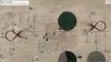
For a visual comparison between non-traditional (non-linear/non-parallel) curved flight lines vs traditional (linear/parallel) flight lines, refer to the following two images.
Minimising systematic error surfaces in digital elevation models using oblique convergent imagery
Rene Wackrow
Jim H. Chandler
First published: 16 March 2011
https://doi.org/10.1111/j.1477-9730.2011.00623.x
Results of the simulation process, the laboratory test and the practical test are reported in this paper and demonstrate that an oblique convergent image configuration eradicates the systematic error surfaces which result from inaccurate lens distortion parameters. This approach is significant because by removing the need for an accurate lens model it effectively improves the accuracies of digital surface representations derived using consumer‐grade digital cameras. Carefully selected image configurations could therefore provide new opportunities for improving the quality of photogrammetrically acquired data.
For a visual comparison between non-traditional (non-linear/non-parallel) curved flight lines vs traditional (linear/parallel) flight lines, refer to the following two images.
Attachments
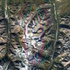
I've been adapting my curved flight lines (waypoint generator) to address the needs of long, narrow corridors (electric power transmission). In this example, the target corridor is about one mile long and 2200' wide. The corridor was flown using a fixed-wing drone flying at a speed of 31mph and a height of 400' AGL. In this mission plan, there are no linear flight line segments; and no flight line segment is parallel to any other segment. Therefore, no two images captured have the same orientation. The objective is to mitigate the systematic SfM doming (elevation) error.
Attachments
- Joined
- Feb 22, 2017
- Messages
- 2,093
- Reactions
- 1,301
- Location
- 48°18'25"N 11°52'10"E
- Site
- skydrone-systems.com
Do you mind sharing your generator? (in the hope it'll generate .KML and not only .CSV)(waypoint generator)
Thank you.
AMann
Well-Known Member
I have a project idea in mind for a waypoint mission that would have pretty sensational results, and it would be legal under FAA rules. Is there a way to use Litchi or another app like it to selectively control a release based on waypoints?
Similar threads
- Replies
- 1
- Views
- 3K


DJI Drone Deals
New Threads
-

-
 Mini 4 Pro Istanbul where the East meets West - Eminönü
- Started by MPone
- Replies: 1
-
 Wanting to understand "Power Banks" and what I'll need....
- Started by MavicFlyer2
- Replies: 3
-
-

Members online
Total: 3,693 (members: 12, guests: 3,681)
Forum statistics
