This will be my last post on this thread. I’m traveling, and really don’t need to convince
@MS Coast or anyone else of anything at all. I have developed little patience for the threads that span multiple pages of bloviated arguments back and forth. I’m sharing my experiences, perceptions, ideas, and concerns - that’s all. I’ll explain a little more of what I wrote in two previous posts, but three is my self-imposed limit.
Typo. That's not HBO, it's HIO or KHIO - Portland-Hillsboro Airport. Class D airspace...
Quite right - HIO. I’d caught that too. I’ve only flown that area once.
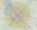
…I've superimposed the FAA's UAS Facility Map grid over DJI's Geo Zone Map for KHIO. (Quotation marks added to the urls to prevent them from loading content.
View attachment 173367
Which part of the outer yellow and orange rings do you consider to be Class G airspace where DJI should not be issuing warnings?...
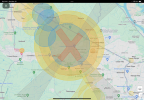
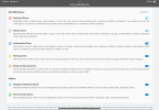
Nice graphic - it helps! You’re right in this case that the yellow and orange rings match the LAANC grid cells fairly closely. However, the gray “X” graphic shows that DJI enforces an Altitude Zone beyond the LAANC grid. I flew outside of the grid but was restricted to 140’ altitude in that Altitude Zone, which was not enough to get the shot I wanted. If you look at the legend I posted, DJI doesn’t really say what’s going to happen in a gray area. It might be a warning, or it might restrict your altitude. In this case the FAA says 400’ is OK with no LAANC clearance required, but DJI says no, not OK.
…Corp means corporate? Would you give some real examples of corporate-state airspace controls?...
That’s one. DJI is restricting flight operations that are otherwise completely legal and allowable by law and regulation. They are dictating as if they have the umbrella of law supporting their decisions. In truth sometimes they do and sometimes they don’t, and users are left with this hodge-podge of loose ends to wrangle. They are doing something that other drone manufacturers haven’t done (yet?). I could pilot my automobile or a conventional aircraft without the manufacturer’s interference, but not a DJI drone.
I think I had 7 or 8 custom unlocks last year. What a hassle. You? LAANC is a great system with several readily navigable apps and websites. The user experience of DJI FlySafe is somewhere between a small nag, to must be online, to must research and navigate a super confusing webservice, or a no-fly, depending on the area, which sometimes is not consistent with actual regs and the real airspace.
…No, the DJI system does not fully echo the FAA regulations or any other civil aviation authority's regulations. It doesn't replace a pilot's need to understand and abide by those regulations. The super system you are asking for would allow pilots to ignore the airspace regulations entirely.
It's really not that complex.
- Don't fly in airspace unless you know know it's legal in advance.
- If you don't know, use one of the simple and readily available free apps to check.
(Rule of thumb for airports - If TSA is going to check your ID when you take a flight from that airport, you need FAA approval to fly your drone there.)
- If you need LAANC authorization, get it in advance and unlock the area on DJI's system.
Yes, it's less convenient that doing no planning and relying on your drone to ensure that you're abiding by the regulations. But drones are aircraft that require pilots. They're not failsafe toys…
Quite right, that’s the regulatory environment we fly in. I myself do all that and more, and have helped many college students get their TRUST and Pt. 107 certificates, helping them learn regs and best practices. Philosophically, I believe in education over nanny-ware.
My own experience tells me DJI does not have it right. “Unlock the area on DJI’s system” is difficult for many, and unknown to many people posting on this forum. So many threads start with “I know I’m in unrestricted airspace”, or “I have LAANC clearance”. I would much prefer that DJI either drop FlySafe, or fix its poor interface and make it known directly to registered users.
…Where are those databases available? Are they updated daily? If the system you want is implemented, won't DJI have to require airspace database update checks before takeoff for every flight? And since some folks don't keep their firmware up to date, wouldn't a firmware update check be necessary for each flight? Both of those would require wifi or data access for every flight. Not something I'd like to see.
FAA publishes airspace info (AIS) in several forms,
including right here (link). They are updated regularly.
DJI already publishes GEO Zone updates regularly that update all the way to the drone. Why is there a disconnect between those updates and actual airspace restrictions?
I myself am not in favor of a switch to required updates, so, no, not something I’d like to see either.


