


You are using an out of date browser. It may not display this or other websites correctly.
You should upgrade or use an alternative browser.
You should upgrade or use an alternative browser.
"DJI Viewer" - new software for DJI drone video playback
- Thread starter wanderer
- Start date
- Status
- Not open for further replies.
HighlandsVideo
Well-Known Member
- Joined
- Jul 27, 2017
- Messages
- 173
- Reactions
- 64
- Age
- 75
Yes! I would most assuredly find this viewer to be vary useful. Let us know when it's available.Hi Everyone,
I am trying to gauge interest in new software I developed, tentatively called “DJI Viewer”. This software allows you to view your drone videos in a whole new way.
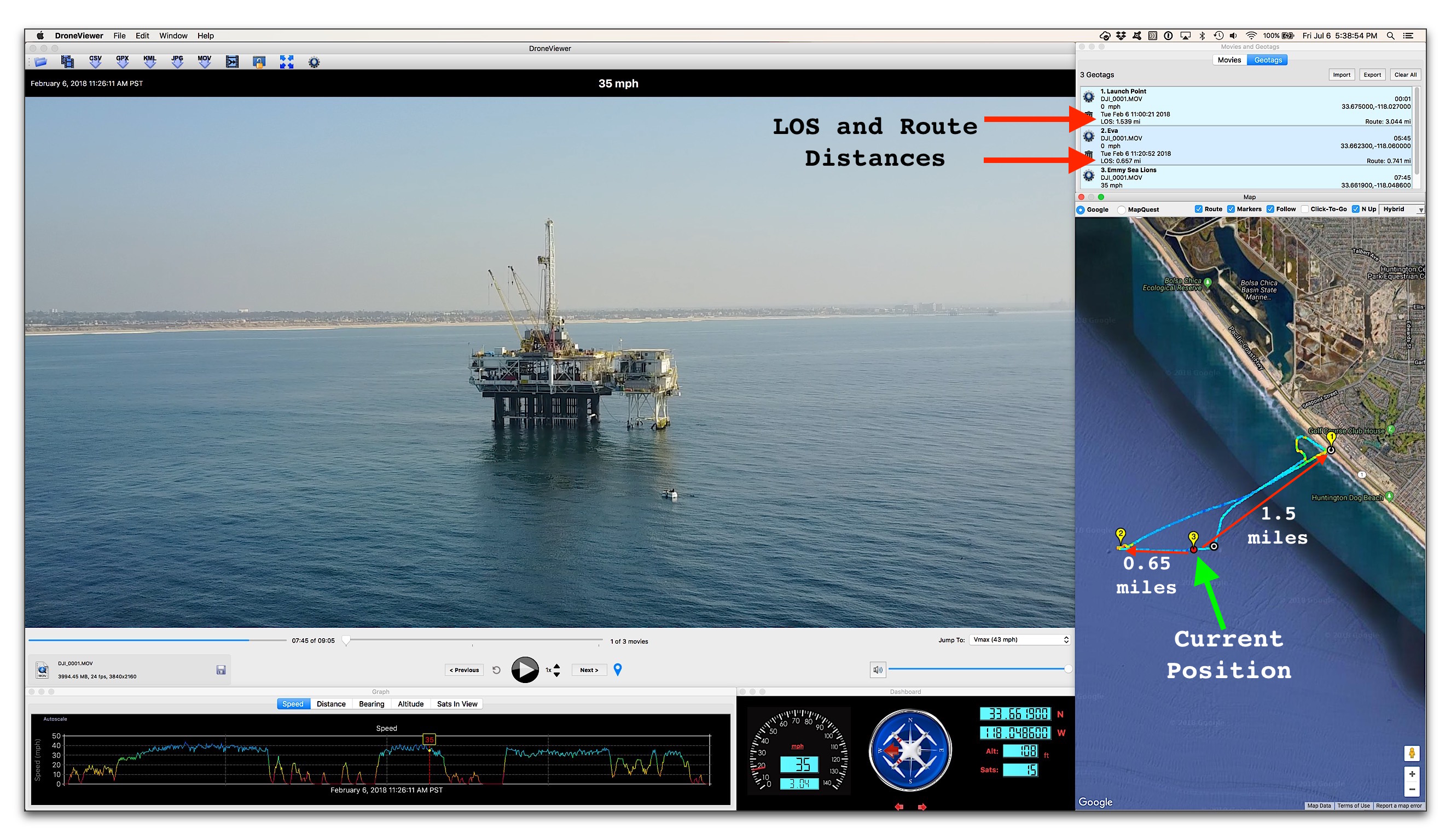
While your movie is playing you can see your drone's position update on a Google Map. You can geotag key positions in the video and jump back to them instantly. You can click on your route in the Map View to jump immediately to that point in the movie. You can export portions of your videos to separate clips, or export just a single geotagged frame. DJI Viewer has multiple views including graphs of your drone's speed, altitude, distance, and bearing. Imperial and metric units are supported. The software has been localized for Chinese, Dutch, French, German, Hungarian, Russian, Spanish, Turkish, and Vietnamese. And, importantly, DJI Viewer runs on both macOS and Windows computers. It is compatible with the SRT data files produced by the Mavic Pro, Phantom 3, Phantom 4 and possibly other DJI drones. Applications include surveying, oil and gas research, search and rescue, archeology, geography, and just plain fun.
I believe it would make a useful companion-application to the family of DJI drones. I'm hoping that DJI will endorse, support, or best of all, license the software for all DJI customers. If you think it would be useful please let me (and DJI) know. I haven't released it yet.
Here are the main features:
- Zoomable, translatable, resizable movie view
- “Real time” display of drone's location on a Map
- Automatically center map on vehicle, or keep map fixed
- Drone route color-coded by speed
- Click on drone's map route to jump to that position in movie
- Heads-up display of current date, time, speed, distance, position, and bearing
- Heads-up display of altitude and Satellites-in-View
- Speedometer display of speed
- Compass display of direction
- Weather widget for retrieving weather conditions at the location and time of movie
- Graphs of speed, distance, altitude, bearing, and satellites-in-View
- Click on vehicle’s Graph trace to jump to that position in movie
- Autoscale Graph views
- Geotag points of interest and instant jump to those points in the movie sequence
- Import and export Geotags to a file
- “Real time” display of drone's line-of-sight distance from geotagged points
- Movie List view shows drone's top speed in each movie
- Remove uninteresting movies from the various views
- Export sections of movies to separate movie files
- Combine multiple movies into a single large movie
- Variable playback speed control
- Jump to fastest part of route instantly
- Jump to any loaded movie instantly
- Slider controls for switching between movies
- Info display of movie file name, file size, and frame rate
- Drag and drop loading of movies
- Drag and drop loading of movie directories
- GPS data export to CSV, KML, and GPX file formats
- GPS data import of GPX file format
- Export current movie window to JPG or PNG file
- Auto-load movie directory upon start-up
- Click to reveal currently-playing movie in Finder/Explorer
- Support for kph or mph units
- Support for timezone biasing
- Documented keyboard and mouse shortcuts
- Support for internet proxy server connection
- User-selectable language support: English, Chinese, Dutch, French, German, Hungarian, Russian, Spanish, Turkish, and Vietnamese
- Users Manual
Thanks!
- wanderer
HoozierDroneDaddy
Well-Known Member
- Joined
- Mar 12, 2017
- Messages
- 825
- Reactions
- 536
- Age
- 71
Hi Everyone,
I am trying to gauge interest in new software I developed, tentatively called “DJI Viewer”. This software allows you to view your drone videos in a whole new way.
While your movie is playing you can see your drone's position update on a Google Map. You can geotag key positions in the video and jump back to them instantly. You can click on your route in the Map View to jump immediately to that point in the movie. You can export portions of your videos to separate clips, or export just a single geotagged frame. DJI Viewer has multiple views including graphs of your drone's speed, altitude, distance, and bearing. Imperial and metric units are supported. The software has been localized for Chinese, Dutch, French, German, Hungarian, Russian, Spanish, Turkish, and Vietnamese. And, importantly, DJI Viewer runs on both macOS and Windows computers. It is compatible with the SRT data files produced by the Mavic Pro, Phantom 3, Phantom 4 and possibly other DJI drones. Applications include surveying, oil and gas research, search and rescue, archeology, geography, and just plain fun.
I believe it would make a useful companion-application to the family of DJI drones. I'm hoping that DJI will endorse, support, or best of all, license the software for all DJI customers. If you think it would be useful please let me (and DJI) know. I haven't released it yet.
Here are the main features:
- Zoomable, translatable, resizable movie view
- “Real time” display of drone's location on a Map
- Automatically center map on vehicle, or keep map fixed
- Drone route color-coded by speed
- Click on drone's map route to jump to that position in movie
- Heads-up display of current date, time, speed, distance, position, and bearing
- Heads-up display of altitude and Satellites-in-View
- Speedometer display of speed
- Compass display of direction
- Weather widget for retrieving weather conditions at the location and time of movie
- Graphs of speed, distance, altitude, bearing, and satellites-in-View
- Click on vehicle’s Graph trace to jump to that position in movie
- Autoscale Graph views
- Geotag points of interest and instant jump to those points in the movie sequence
- Import and export Geotags to a file
- “Real time” display of drone's line-of-sight distance from geotagged points
- Movie List view shows drone's top speed in each movie
- Remove uninteresting movies from the various views
- Export sections of movies to separate movie files
- Combine multiple movies into a single large movie
- Variable playback speed control
- Jump to fastest part of route instantly
- Jump to any loaded movie instantly
- Slider controls for switching between movies
- Info display of movie file name, file size, and frame rate
- Drag and drop loading of movies
- Drag and drop loading of movie directories
- GPS data export to CSV, KML, and GPX file formats
- GPS data import of GPX file format
- Export current movie window to JPG or PNG file
- Auto-load movie directory upon start-up
- Click to reveal currently-playing movie in Finder/Explorer
- Support for kph or mph units
- Support for timezone biasing
- Documented keyboard and mouse shortcuts
- Support for internet proxy server connection
- User-selectable language support: English, Chinese, Dutch, French, German, Hungarian, Russian, Spanish, Turkish, and Vietnamese
- Users Manual
Thanks!
- wanderer
Wanderer, This is a Great Application, Awesome job! I would like to make one suggestion that would add many others to the list of "I would buy it". Since you have all the needed data, why not add an "Export to Flight Log" option to the menu that would build a continuous flight log file of all flights with the date/time/flight length/batteries/distances/etc., etc., etc. This would save so much time for commercial pilots to track and log their flights for insurance, licensing, etc. Again, Fantastic Job on the Program. I hope you make it available soon and notify those of us who have responded when it does become available. Thanks for Sharing.

SkyIScrape
Active Member
SkyShark1971
Member
- Joined
- Jan 5, 2018
- Messages
- 2,814
- Reactions
- 6,012
- Age
- 78
Looks very interesting. I like to keep things simple. So, have to wait and read Users Manual.Hi Everyone,
I am trying to gauge interest in new software I developed, tentatively called “DJI Viewer”. This software allows you to view your drone videos in a whole new way.
While your movie is playing you can see your drone's position update on a Google Map. You can geotag key positions in the video and jump back to them instantly. You can click on your route in the Map View to jump immediately to that point in the movie. You can export portions of your videos to separate clips, or export just a single geotagged frame. DJI Viewer has multiple views including graphs of your drone's speed, altitude, distance, and bearing. Imperial and metric units are supported. The software has been localized for Chinese, Dutch, French, German, Hungarian, Russian, Spanish, Turkish, and Vietnamese. And, importantly, DJI Viewer runs on both macOS and Windows computers. It is compatible with the SRT data files produced by the Mavic Pro, Phantom 3, Phantom 4 and possibly other DJI drones. Applications include surveying, oil and gas research, search and rescue, archeology, geography, and just plain fun.
I believe it would make a useful companion-application to the family of DJI drones. I'm hoping that DJI will endorse, support, or best of all, license the software for all DJI customers. If you think it would be useful please let me (and DJI) know. I haven't released it yet.
Here are the main features:
- Zoomable, translatable, resizable movie view
- “Real time” display of drone's location on a Map
- Automatically center map on vehicle, or keep map fixed
- Drone route color-coded by speed
- Click on drone's map route to jump to that position in movie
- Heads-up display of current date, time, speed, distance, position, and bearing
- Heads-up display of altitude and Satellites-in-View
- Speedometer display of speed
- Compass display of direction
- Weather widget for retrieving weather conditions at the location and time of movie
- Graphs of speed, distance, altitude, bearing, and satellites-in-View
- Click on vehicle’s Graph trace to jump to that position in movie
- Autoscale Graph views
- Geotag points of interest and instant jump to those points in the movie sequence
- Import and export Geotags to a file
- “Real time” display of drone's line-of-sight distance from geotagged points
- Movie List view shows drone's top speed in each movie
- Remove uninteresting movies from the various views
- Export sections of movies to separate movie files
- Combine multiple movies into a single large movie
- Variable playback speed control
- Jump to fastest part of route instantly
- Jump to any loaded movie instantly
- Slider controls for switching between movies
- Info display of movie file name, file size, and frame rate
- Drag and drop loading of movies
- Drag and drop loading of movie directories
- GPS data export to CSV, KML, and GPX file formats
- GPS data import of GPX file format
- Export current movie window to JPG or PNG file
- Auto-load movie directory upon start-up
- Click to reveal currently-playing movie in Finder/Explorer
- Support for kph or mph units
- Support for timezone biasing
- Documented keyboard and mouse shortcuts
- Support for internet proxy server connection
- User-selectable language support: English, Chinese, Dutch, French, German, Hungarian, Russian, Spanish, Turkish, and Vietnamese
- Users Manual
Thanks!
- wanderer
Wanderer, This is a Great Application, Awesome job! I would like to make one suggestion that would add many others to the list of "I would buy it". Since you have all the needed data, why not add an "Export to Flight Log" option to the menu that would build a continuous flight log file of all flights with the date/time/flight length/batteries/distances/etc., etc., etc. This would save so much time for commercial pilots to track and log their flights for insurance, licensing, etc. Again, Fantastic Job on the Program. I hope you make it available soon and notify those of us who have responded when it does become available. Thanks for Sharing.
I like this idea and can certainly add it to the job jar.
I've decided to release this software with or without DJI's support. The s/w itself is essentially complete. Just working on new graphics, User's Manual, a website, etc.-- all the things that need to be in place before properly releasing software into the wild. Thanks for your patience and support!
HoozierDroneDaddy
Well-Known Member
- Joined
- Mar 12, 2017
- Messages
- 825
- Reactions
- 536
- Age
- 71
I like this idea and can certainly add it to the job jar.
I've decided to release this software with or without DJI's support. The s/w itself is essentially complete. Just working on new graphics, User's Manual, a website, etc.-- all the things that need to be in place before properly releasing software into the wild. Thanks for your patience and support!
Thanks You Wanderer. I am sure there will be many others anxiously awaiting its release. I have also posted your initial post with the program info on some other groups I am in, and there are more people highly interested in it when released. Please let us know when and where we can find it when you release it. Thanks from many for taking the time to develop this great tool.
I like this idea and can certainly add it to the job jar.
I've decided to release this software with or without DJI's support. The s/w itself is essentially complete. Just working on new graphics, User's Manual, a website, etc.-- all the things that need to be in place before properly releasing software into the wild. Thanks for your patience and support!
Excellent, I'm looking forward to checking it out!!
Stach
JeffCharger
Well-Known Member
- Joined
- Jan 5, 2017
- Messages
- 124
- Reactions
- 65
Oconnb910
Well-Known Member
Moozer
Active Member
Looks terrific! Would definitely demonstrate it to all the students in my drone classes! Do let us know if you need any testers, and of course, when it's available.
beachcombing
Well-Known Member
- Joined
- Oct 21, 2016
- Messages
- 660
- Reactions
- 405
The software looks very cool. I would definitely be interested.I like this idea and can certainly add it to the job jar.
I've decided to release this software with or without DJI's support. The s/w itself is essentially complete. Just working on new graphics, User's Manual, a website, etc.-- all the things that need to be in place before properly releasing software into the wild. Thanks for your patience and support!
I would caution you against using DJI's name and certainly their logo without their express, written permission. A copyright lawsuit would certainly dampened your success.
Just wanted to update folks interested in the software: Since I haven't heard anything from DJI, I've officially released the software under the name "DroneViewer v1.0.0". Both Mac and Windows versions are available for download now. Please take it for a spin.
Under the Help menu you'll find a 60-page User's Manual that comes with the download. Also, the website has a "Getting Started" section which shows how to prepare GPS data for use with DroneViewer. I plan to add support for additional GPS data formats as the software evolves. Thanks for your patience!
Website : https://mydroneviewer.com
-wanderer
istrait
Well-Known Member
I am trying your demo version before purchasing and at first glance it is a very professional piece of software.
I may be missing something in the instructions but I am only getting the movie playing, no map or speed data.
I may be missing something in the instructions but I am only getting the movie playing, no map or speed data.
istrait
Well-Known Member
I am trying your demo version before purchasing and at first glance it is a very professional piece of software.
I may be missing something in the instructions but I am only getting the movie playing, no map or speed data.
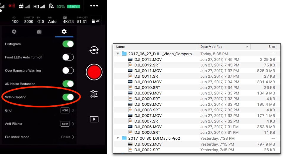
From the getting started page (Getting Started)...
Importing drone flight data from a DJI SRT file
If your DJI drone is controlled by the DJI Go 4 App (used to fly the Mavic Pro, Phantom 4), then you can easily import your flight trajectory into DroneViewer via the SRT file. Before your flight, be sure you turn on the Video Caption option in the Go App camera settings.
beachcombing
Well-Known Member
- Joined
- Oct 21, 2016
- Messages
- 660
- Reactions
- 405
I'm checking out the software, as well. Seems very interesting. Although, for me, I'm am quite distracted by you calling the videos from the drone "movies' throughout the software and the documentation. Isn't "videos" a better description of the media files? Just my two cents.Just wanted to update folks interested in the software: Since I haven't heard anything from DJI, I've officially released the software under the name "DroneViewer v1.0.0". Both Mac and Windows versions are available for download now. Please take it for a spin.
Under the Help menu you'll find a 60-page User's Manual that comes with the download. Also, the website has a "Getting Started" section which shows how to prepare GPS data for use with DroneViewer. I plan to add support for additional GPS data formats as the software evolves. Thanks for your patience!
Website : https://mydroneviewer.com
-wanderer
istrait
Well-Known Member
- Status
- Not open for further replies.
Similar threads
- Replies
- 1
- Views
- 564
- Replies
- 37
- Views
- 1K
- Replies
- 3
- Views
- 1K


DJI Drone Deals
1. Mini 2
2. Mini 3 Pro
3. Mini 4 Pro
4. Air 2s
5. Air 3
6. Avata 2
7. Mavic 3 Pro
8. Mavic 3 Classic
2. Mini 3 Pro
3. Mini 4 Pro
4. Air 2s
5. Air 3
6. Avata 2
7. Mavic 3 Pro
8. Mavic 3 Classic
Forum statistics
