

Hi guys, first post here and a terrible one , but any help would be greatly appreciated. I was at the beach yesterday and done a distance run with my mavic as I come back to me there was 2 big eagles flying nearby so I went overhead and out of there path. anyhow long story short battery went to critically low when I was in a bit of a panic. the last thing I could see on dji go app was it said landing was roughly 30m in the air and travelling at about 30kph. thanks very much for any help I may receive. cheers mat

You are using an out of date browser. It may not display this or other websites correctly.
You should upgrade or use an alternative browser.
You should upgrade or use an alternative browser.
I've lost my mavic pro any help would be appreciated
- Thread starter Mat685
- Start date

ksmusa
Well-Known Member
Have you tried using the “Find My Drone” function within DJI go??
DJI Find My Drone Feature - Overview
DJI Find My Drone Feature - Overview
- Joined
- Oct 12, 2016
- Messages
- 28,424
- Reactions
- 31,319
- Location
- Harrisburg, PA (US)
- Site
- mavichelp.com
Here's your uploaded flight log:
DJI Flight Log Viewer - PhantomHelp.com
DJI Flight Log Viewer - PhantomHelp.com
- Joined
- Oct 12, 2016
- Messages
- 28,424
- Reactions
- 31,319
- Location
- Harrisburg, PA (US)
- Site
- mavichelp.com
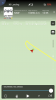
Your flight log shows it was last at -29.29489974, 153.3394317 flying toward you at 18 MPH. That area looks like it's densely populated with trees, so it could be a tough search. If you're able to get to that location, start searching from that point toward where you were flying on the beach.
lisadoc
Well-Known Member
- Joined
- May 29, 2017
- Messages
- 1,014
- Reactions
- 691
I was at the beach yesterday and done a distance run with my mavic as I come back to me there was 2 big eagles flying nearby so I went overhead and out of there path. anyhow long story short battery went to critically low when I was in a bit of a panic. the last thing I could see on dji go app was it said landing was roughly 30m in the air and travelling at about 30kph.
I'm confused. First, you're over 4.25 kilometers out to sea when your Mavic tells you that it only has enough battery to RTH. You ignore that warning and continue in the opposite direction (further away from you) another +1,500 feet (meaning an additional kilometer round-trip), when you finally decide to turn around. By the grace of the drone gods, you make it back to your position on the beach with roughly 14% battery left (at a height of 65 feet). Instead of immediately landing, you say you were spooked by 2 big "eagles" (on the beach? White-bellied Sea-Eagles?) and instead of going straight up (or down), you decide to continue away from you inland. You fly another 1,800 feet in distance (again, meaning more than +1 km round trip) and climb an additional 135 ft in altitude until your battery reaches 10% and enters forced critical battery landing. Do I have something wrong?
Either way, you're going to have to go find it. It's deep in the bush and potentially up in a tree. Here's your location from Google Earth. It's likely immediately under the last point where you had a signal, as it was in landing mode (it would have stopped coming back in your direction after the signal was lost and landed straight down). You'll need to hack through the bush and bring a GPS device (phone, etc.), hoping you'll get a signal under the canopy. Here are the GPS coordinates ( 29°17'40.83"S, 153°20'22.10"E). Good luck mate.


Last edited:
Thanks mateSorry for your loss. Experts please help this unfortunately pilot. :/
Your flight log shows it was last at -29.29489974, 153.3394317 flying toward you at 18 MPH. That area looks like it's densely populated with trees, so it could be a tough search. If you're able to get to that location, start searching from that point toward where you were flying on the beach.
Your flight log shows it was last at -29.29489974, 153.3394317 flying toward you at 18 MPH. That area looks like it's densely populated with trees, so it could be a tough search. If you're able to get to that location, start searching from that point toward where you were flying on the beach.
No mate your pretty spot on with what you said there and yes white bellied sea eagles I’m pretty sure. I had never been to 10% before and didn’t realise it would force landing stupid I know, but I can’t change it now. when I went to climb was when I lost vision on my app and was trying to get it back so I could come home. I was out there yesterday looking once I got through thick bush out where the mavic should be there’s not really any big trees as such. I’ve added 3 photos of maps I had on where the drone ended up they all seem so show it heading in another direction which is what confused me. Thanks very much for your time really appreciate it.I'm confused. First, you're over 4.25 kilometers out to sea when your Mavic tells you that it only has enough battery to RTH. You ignore that warning and continue in the opposite direction (further away from you) another +1,500 feet (meaning an additional kilometer round-trip), when you finally decide to turn around. By the grace of the drone gods, you make it back to your position on the beach with roughly 14% battery left (at a height of 65 feet). Instead of immediately landing, you say you were spooked by 2 big "eagles" (on the beach? White-bellied Sea-Eagles?) and instead of going straight up (or down), you decide to continue away from you inland. You fly another 1,800 feet in distance (again, meaning more than +1 km round trip) and climb an additional 135 ft in altitude until your battery reaches 10% and enters forced critical battery landing. Do I have something wrong?
Either way, you're going to have to go find it. It's deep in the bush and potentially up in a tree. Here's your location from Google Earth. It's likely immediately under the last point where you had a signal, as it was in landing mode (it would have stopped coming back in your direction after the signal was lost and landed straight down). You'll need to hack through the bush and bring a GPS device (phone, etc.), hoping you'll get a signal under the canopy. Here are the GPS coordinates ( 29°17'40.83"S, 153°20'22.10"E). Good luck mate.
View attachment 34795 View attachment 34796
Attachments
-
 C33DA804-1486-401D-A8BF-6F3BDC0C0C11.png266.4 KB · Views: 167
 -
 F653CE6E-F9F7-4714-B082-2390F27BAE09.jpeg1 MB · Views: 206
 -
 9B04711B-9392-4B75-9439-88886C2FC8C5.jpeg751.2 KB · Views: 191
 -
 3CB0D0B9-491F-4522-AE19-6583ED07D525.png225.5 KB · Views: 169
 -
 C92D3169-CA5F-49CC-A80C-2C1C1AEF5AFA.png4.3 MB · Views: 180
Yep I lost all signal when it was still in the air Have you tried using the “Find My Drone” function within DJI go??
DJI Find My Drone Feature - Overview
 Thanks very much for your help
- Joined
- May 27, 2017
- Messages
- 14,458
- Reactions
- 19,470
- Location
- Los Alamos, NM
- Site
- www.mavicpilots.com
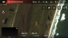
The advice above is all good, but there is one subtlety here that you might want to pay attention to. Despite the appearance of the track when displayed, at the end of the recorded flight you had just applied CCW rudder and it was actually on a heading of 48° and you were applying full forward elevator. It's velocity was east at 8.5 m/s but it was turning to make its track 48°. When the downlink was lost we lose all information about what was happening, but if uplink continued and you continued to apply forward elevator, it may have continued to travel.
It was at approximately at 25 m AGL descending at 2.5 m/s. I've no idea how tall the vegetation is there, but the vision system had not detected the ground. So, a maximum estimate of travel would be 85 m on a 48° track, taking it to -29.294369°, 153.340053°, while the minimum estimate is that it landed where the downlink disconnected. I would search alone that line from the last known point.

It was at approximately at 25 m AGL descending at 2.5 m/s. I've no idea how tall the vegetation is there, but the vision system had not detected the ground. So, a maximum estimate of travel would be 85 m on a 48° track, taking it to -29.294369°, 153.340053°, while the minimum estimate is that it landed where the downlink disconnected. I would search alone that line from the last known point.
I'm confused. First, you're over 4.25 kilometers out to sea when your Mavic tells you that it only has enough battery to RTH. You ignore that warning and continue in the opposite direction (further away from you) another +1,500 feet (meaning an additional kilometer round-trip), when you finally decide to turn around. By the grace of the drone gods, you make it back to your position on the beach with roughly 14% battery left (at a height of 65 feet). Instead of immediately landing, you say you were spooked by 2 big "eagles" (on the beach? White-bellied Sea-Eagles?) and instead of going straight up (or down), you decide to continue away from you inland. You fly another 1,800 feet in distance (again, meaning more than +1 km round trip) and climb an additional 135 ft in altitude until your battery reaches 10% and enters forced critical battery landing. Do I have something wrong?
Either way, you're going to have to go find it. It's deep in the bush and potentially up in a tree. Here's your location from Google Earth. It's likely immediately under the last point where you had a signal, as it was in landing mode (it would have stopped coming back in your direction after the signal was lost and landed straight down). You'll need to hack through the bush and bring a GPS device (phone, etc.), hoping you'll get a signal under the canopy. Here are the GPS coordinates ( 29°17'40.83"S, 153°20'22.10"E). Good luck mate.
View attachment 34795 View attachment 34796
This is so common it is not funny.. 90 percent of the lost drones here are because folks cancel the Automatic RTH.
Thanks so much sar that should help lots I’ve just arrived to the beach now and will track in there shortly. A friend is bringing an inspire down to have a look from the air aswell majority of the the ground veg is like 1-2ft and them trees are maybe 3-4 I don’t recall anything out there being taller then me. Thanks again for your reply honestly appreciate it. Cheers mat
I don’t doubt that for a minute, I’ve stuffed up big time but not much I can do now other then try and find it I guess. This has been a massive lesson for me.This is so common it is not funny.. 90 percent of the lost drones here are because folks cancel the Automatic RTH.
joejaxvic123
Well-Known Member
- Joined
- Dec 30, 2017
- Messages
- 567
- Reactions
- 259
- Age
- 53
I wasn't trying to be a jerk bud. I was just replying to the other user but canceling the RTH is a bad idea if it does it automatically unless you see an obstacle or need to book it in sports mode back.I don’t doubt that for a minute, I’ve stuffed up big time but not much I can do now other then try and find it I guess. This has been a massive lesson for me.
never ceases to amaze me how far these will fly, and I don't have the guts to fly mine anywhere near as far as it can fly-if I lose sight of mine (at maybe 1800-2000 feet), I rely on the images being transmitted and the radar tracker on the lower left corner-but not being able to SEE the bird is still unnerving. If I look down at the screen to actually see how far away I am, I can lose sight of it when I look up, so I tend to try to stand in the center of a wide open area and I will fly out maybe 2000+ feet, bring it back and then go 2000+ feet in the opposite direction...I used to have a Phantom 3 Standard and could actually fly it out further since, being larger, it was easy to see at 2000+ feet. I cannot image being out almost 15,000 feet!
Hi Tas, I didn’t have much luck I went out there twice for about an hour each time, it’s terrible terrain to be trying to find anything in not to mention getting in and out of there on foot. I’ll purchase a new one this week and put a gps on it although I cannot see myself doing anything this stupid again . Will be nice to have a few extra battery’s aswell.What was the result of your search?
G’day jay, yeah I know that all good, I’ve learnt the hard way here. I’ve given up on it, I’ll buy a fresh one and take a bit more care in my actions from now on. Cheers matI wasn't trying to be a jerk bud. I was just replying to the other user but canceling the RTH is a bad idea if it does it automatically unless you see an obstacle or need to book it in sports mode back.
Hi Mmt, yep it’s pretty crazy how far they will go and from memory it’s still had good signal strength and my feed was clear also. intentions of that flight where just to increase my max flight distance on the go 4 app. You do loose sight of them Pretty easily I certainly agree with that. The flight I lost it went nearly 10.1ks that’s the only positive I ended up with that day haha. Have fun flyingnever ceases to amaze me how far these will fly, and I don't have the guts to fly mine anywhere near as far as it can fly-if I lose sight of mine (at maybe 1800-2000 feet), I rely on the images being transmitted and the radar tracker on the lower left corner-but not being able to SEE the bird is still unnerving. If I look down at the screen to actually see how far away I am, I can lose sight of it when I look up, so I tend to try to stand in the center of a wide open area and I will fly out maybe 2000+ feet, bring it back and then go 2000+ feet in the opposite direction...I used to have a Phantom 3 Standard and could actually fly it out further since, being larger, it was easy to see at 2000+ feet. I cannot image being out almost 15,000 feet!
Similar threads
- Replies
- 5
- Views
- 1K
- Replies
- 8
- Views
- 1K
- Replies
- 6
- Views
- 725
- Replies
- 19
- Views
- 3K


DJI Drone Deals
1. Mini 2
2. Mini 3 Pro
3. Mini 4 Pro
4. Air 2s
5. Air 3
6. Avata 2
7. Mavic 3 Pro
8. Mavic 3 Classic
2. Mini 3 Pro
3. Mini 4 Pro
4. Air 2s
5. Air 3
6. Avata 2
7. Mavic 3 Pro
8. Mavic 3 Classic
New Threads
-

-
Automation and AI are we missing the wood for the trees ?
- Started by Pacefast
- Replies: 0
-
-
Thermal Mavic 2 Enterprise Advanced great condition 4 batteries
- Started by Gtr
- Replies: 0
-
Forum statistics
