


D
Deleted member 103366
Guest
I took a 2nd hand mini out yesterday for its first out-of-my-garden flight. I wanted to test some features.
Basically it was a fly out to 'sea' and buzz about flight.
Early in the flight I did an RTH from a distance of maybe 130m+, watching the drone it appeared to be descending.
When a drone is at distance and the angle of elevation is small I do find it difficult at times to tell if a drone is flying away from me or descending, likewise 'returning' vs climbing, But,at the height I was flying, RTH would initiate with a climb so an apparent descent was alarming.
A descent where it was would have sent it for a swim so, from memory, I opened the throttle and saw it start to climb, then I released throttle and the climb to RTH height continued.
For the rest of the flight various RTH's produced no unusual behaviour.
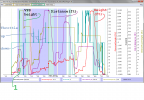
The chart below is from the flight log of the flight and it seems in accordance with my memory of this incident.
The ringed area marked "1" is, I think, this descent.
Purple shading is sports mode, light blue is RTH, white is, I think, P mode, pink is auto descent during or at the end of RTH.
Whilst looking at the reported heights in the chart I noticed that the drone seems to have a tendency to climb (red trace) whilst flying laterally, unfortunately most of the flight was above VPS range.
The beach has a reasonable intial shoreline slope but quickly levels of to almost horizontal. From childhood memories of this beach the close-to horizontal bits wouldn't be much more than 3 to 4ft deep at high tide so I doubt I went below the take off point, the height trace indicates negative heights at various points.
Sorry I will not post the actual logs.
With regards to the descent at the start of the first RTH, is/are there any column/s in the logs that I should look at to investigate this?
It's a bit scarey, with my original MM (the 2nd hand one is a back up) I once, over open sea, flew out to signal loss, the height would have been maybe 70ft above sea level. If it had descended at the start of RTH it would quickly have been fish food.
With regards to the apparent climb. I believe the height derives (red trace) from barometric readings. Air pressure does vary with approaching weather systems and I am wondering if the apparent climb could be an incoming region of reduced air pressure? (Though that, I think, would not account for negative heights.)
It's a pity I didn't have a hover or traverse over flat, solid ground in this flight that was within VPS range.
Basically it was a fly out to 'sea' and buzz about flight.
Early in the flight I did an RTH from a distance of maybe 130m+, watching the drone it appeared to be descending.
When a drone is at distance and the angle of elevation is small I do find it difficult at times to tell if a drone is flying away from me or descending, likewise 'returning' vs climbing, But,at the height I was flying, RTH would initiate with a climb so an apparent descent was alarming.
A descent where it was would have sent it for a swim so, from memory, I opened the throttle and saw it start to climb, then I released throttle and the climb to RTH height continued.
For the rest of the flight various RTH's produced no unusual behaviour.
The chart below is from the flight log of the flight and it seems in accordance with my memory of this incident.
The ringed area marked "1" is, I think, this descent.
Purple shading is sports mode, light blue is RTH, white is, I think, P mode, pink is auto descent during or at the end of RTH.
Whilst looking at the reported heights in the chart I noticed that the drone seems to have a tendency to climb (red trace) whilst flying laterally, unfortunately most of the flight was above VPS range.
The beach has a reasonable intial shoreline slope but quickly levels of to almost horizontal. From childhood memories of this beach the close-to horizontal bits wouldn't be much more than 3 to 4ft deep at high tide so I doubt I went below the take off point, the height trace indicates negative heights at various points.
Sorry I will not post the actual logs.
With regards to the descent at the start of the first RTH, is/are there any column/s in the logs that I should look at to investigate this?
It's a bit scarey, with my original MM (the 2nd hand one is a back up) I once, over open sea, flew out to signal loss, the height would have been maybe 70ft above sea level. If it had descended at the start of RTH it would quickly have been fish food.
With regards to the apparent climb. I believe the height derives (red trace) from barometric readings. Air pressure does vary with approaching weather systems and I am wondering if the apparent climb could be an incoming region of reduced air pressure? (Though that, I think, would not account for negative heights.)
It's a pity I didn't have a hover or traverse over flat, solid ground in this flight that was within VPS range.
Attachments
Last edited by a moderator:


