I have a Mavic 2 Enterprise Zoom (I was not sure if I should post here or in the dedicated Enterprise section). I have tried 2 times now to use the Mission Flight software to try to get some images for a 2D map. Both times the pictures came out blurry. Other pictures and videos shot the same day and in between the mapping missions come out great so I know its something with my settings on Mission Flight. I tried slowing down the drone from 10m/s to 1m/s and they were still blurry. Any suggestions? Its embarrassing as my backup Parrot Anafi runs the same grid on Pix4D Capture at its highest speed and the pictures come out great.

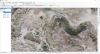
File info on the JPEG - 1/640 Shutter Speed, f/2.8 4.386mm ISO 110 taken from 30 meter height and a 1 m/s speed.
Keep in mind I know the bare minimum about camera settings, but I am learning as we speak.
File info on the JPEG - 1/640 Shutter Speed, f/2.8 4.386mm ISO 110 taken from 30 meter height and a 1 m/s speed.
Keep in mind I know the bare minimum about camera settings, but I am learning as we speak.