DJI Mavic, Air and Mini Drones
Friendly, Helpful & Knowledgeable Community
Join Us Now

Can you fly around Savannah? Not according to the FAA!

So am I reading the maps properly, that the area in my neighborhood has a zero feet ceiling? My plan was go for Part 107 after I had some hands on experience with my drone, but I guess I need to step that up if it would allow me to fly in my local area
I’ve verified with @Vic Moss that this area is E2 and D.

However, there is no UAS Facility Map (UASFM) for this airspace so I don’t understand why they are saying they are denying it for requesting a height above the UAS Facility Map (UASFM) that doesn’t exist.

Maybe the FAA really means recreational pilots can only request heights at or below the UAS Facility Map (UASFM) and since there isn’t one you can’t request any height. I’m not sure though. If it were me I’d resubmit the application and not use blanket area. If that gets denied I’d email the FAA drone email address to find out what is going on.
 
@BigAl07 or anybody else I’m not 100% confident on this this so hoping someone can verify.

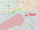
As far as I can see that the green area marked below is an E4 extension of the Class D airspace at SVN due to the dashed blue line. However, you could also interpret it as an E3 extension to the class C airspace of SAV due to the magenta line. Either of these scenarios wouldn’t require an authorization if flying in the green area outlined below.

View attachment 129821
However, the facilities map calls this all E2 airspace, though I’m not seeing that on the chart and don’t really see how that would make sense to begin with.
View attachment 129822

I also don’t understand why the Class D airspace doesn’t have an altitude grid. Even if the class D is not LAANC enabled there should still be altitude boxes.

My advice to the OP was going to be that he doesn’t require authorization to fly as long as he stays out of the Blue and red outlines on the first photo above and can get LAANC authorization to fly in the class C but since the facilities map is saying this whole area is E2 I’d like someone else to confirm for me first.
Yeah, I am just not seeing how this is E2. At least from looking at the sectional charts.
 
@BigAl07 or anybody else I’m not 100% confident on this this so hoping someone can verify.

As far as I can see that the green area marked below is an E4 extension of the Class D airspace at SVN due to the dashed blue line. However, you could also interpret it as an E3 extension to the class C airspace of SAV due to the magenta line. Either of these scenarios wouldn’t require an authorization if flying in the green area outlined below.

View attachment 129821
However, the facilities map calls this all E2 airspace, though I’m not seeing that on the chart and don’t really see how that would make sense to begin with.
View attachment 129822

I also don’t understand why the Class D airspace doesn’t have an altitude grid. Even if the class D is not LAANC enabled there should still be altitude boxes.

My advice to the OP was going to be that he doesn’t require authorization to fly as long as he stays out of the Blue and red outlines on the first photo above and can get LAANC authorization to fly in the class C but since the facilities map is saying this whole area is E2 I’d like someone else to confirm for me first.

Thanks for the feedback! I'm assuming that the Class D area isn't LAANC enabled mostly because it's an Army Airfield, so it's military, not civilian. And, from what I've read, there are still plenty of civilian airfields that aren't LAANC enabled yet.

I guess I'll try another authorization request for a specific area in the D zone (I'll try 1/4 mile). But what's the max altitude? 100ft is plenty. 50's probably OK, too...

(I'm not really interested in flying around the Savannah Airport, though)
 
Last edited:
Thanks for the feedback! I'm assuming that the Class D area isn't LAANC enabled mostly because it's an Army Airfield, so it's military, not civilian. And, from what I've read, there are still plenty of civilian airfields that aren't LAANC enabled yet.

I guess I'll try another authorization request for a specific area in the D zone (I'll try 1/4 mile). But what's the max altitude? 100ft is plenty. 50's probably OK, too...

(I'm not really interested in flying around the Savannah Airport, though)
To be clear I was incorrect it is E2 not E4 so you do have to get authorizations for both the E2 and D.

I would retry your authorizations with the 1/4 mile and mention you will stay out of the special use airspace in the request for the class D.

If they deny it let us know with the reasoning and we’ll go from there. This is a unique situation.
I just submitted the request. I lowered my ceiling to 75ft and reduced it to 1/4 mile. I wonder if there's some sort of terminology they're looking for that I'm not using in my proposed operation description. I'm not really a fan of this "keep poking around until you hit something" approach. They might be ok with 75ft/.25mi or maybe they want it no more than 50ft. Or 50/.1.

The runway approaches are to the East, and that's where you usually see planes and helicopters coming in (that's right over Eisenhower Blvd if you look on a map). And the JEA is a good 1.5 miles North of there. That's really the better request, in terms of places to fly. The park near me is tiny (as is my backyard).

I just powered up my drone for the first time, installed firmware updates and got DJI Care. Tomorrow I'm heading to a friend's place on Tybee Island, which is well outside this zone. So my first (and hopefully not last) flight will be there!
 
  • Like
Reactions: ckoerner
I just submitted the request. I lowered my ceiling to 75ft and reduced it to 1/4 mile. I wonder if there's some sort of terminology they're looking for that I'm not using in my proposed operation description. I'm not really a fan of this "keep poking around until you hit something" approach. They might be ok with 75ft/.25mi or maybe they want it no more than 50ft. Or 50/.1.
To the FAA’s credit it’s normally not like this. In fact I was under the impression that every towered airport had an altitude grid around it on the facilities map telling you exactly what altitudes they would accept until you showed me this one. Apparently there are few others but very few.

Having said that you can get a good idea for what they would accept looking at the altitude grids of other airports and their distance and orientation to the runway. I don’t think height was really the issue I think it was the requested blanket area. F3E860BE-4A78-4690-A483-92F4330E3904.png
 
To the FAA’s credit it’s normally not like this. In fact I was under the impression that every towered airport had an altitude grid around it on the facilities map telling you exactly what altitudes they would accept until you showed me this one. Apparently there are few others but very few.

Having said that you can get a good idea for what they would accept looking at the altitude grids of other airports and their distance and orientation to the runway. I don’t think height was really the issue I think it was the requested blanket area.

That makes sense. I guess they saw that parts of the area were at zero altitude, so that limited me to zero. Kind of like “we can’t give you blanket area authorization because that’s zero feet. Oh, and we don’t do blanket authorization anyway.”

The E2 area near my house is a different story, though. Maybe because of the overlap with SAV airspace to the West? I mean, it’s further from Hunter…
Yea I’m not really sure. Maybe it’s just a matter of policy
 
I just submitted the request. I lowered my ceiling to 75ft and reduced it to 1/4 mile. I wonder if there's some sort of terminology they're looking for that I'm not using in my proposed operation description. I'm not really a fan of this "keep poking around until you hit something" approach. They might be ok with 75ft/.25mi or maybe they want it no more than 50ft. Or 50/.1.

The runway approaches are to the East, and that's where you usually see planes and helicopters coming in (that's right over Eisenhower Blvd if you look on a map). And the JEA is a good 1.5 miles North of there. That's really the better request, in terms of places to fly. The park near me is tiny (as is my backyard).

I just powered up my drone for the first time, installed firmware updates and got DJI Care. Tomorrow I'm heading to a friend's place on Tybee Island, which is well outside this zone. So my first (and hopefully not last) flight will be there!
Tybee Island is a great place to fly! You’ll enjoy it.
 
  • Like
Reactions: s grenald
Well, I know everyone is waiting with baited breath to hear what happened with my latest FAA auth request. To recap: I decided to make this one simpler. I selected the location, and made it a 1/4 mile radius, rather than asking for the whole area. I also lowered my max altitude to 75ft. And the result is...another rejection. This time it was just for the altitude. The text is probably identical to what I got before:

Operations at altitudes above the UAS Facility Map (UASFM) are currently not authorized under Section 44809, Exception for Limited Recreational Operations of Unmanned Aircraft.

I suppose if I get my 107 (which I'm planning on doing, anyway) then this wouldn't be an issue. Although looking at the UAS Facility Map (if I'm reading this correctly), it appears that the rules are inconsistent...

Screen Shot 2021-06-02 at 2.51.49 PM.jpg
 
Well, I know everyone is waiting with baited breath to hear what happened with my latest FAA auth request. To recap: I decided to make this one simpler. I selected the location, and made it a 1/4 mile radius, rather than asking for the whole area. I also lowered my max altitude to 75ft. And the result is...another rejection. This time it was just for the altitude. The text is probably identical to what I got before:

Operations at altitudes above the UAS Facility Map (UASFM) are currently not authorized under Section 44809, Exception for Limited Recreational Operations of Unmanned Aircraft.

I suppose if I get my 107 (which I'm planning on doing, anyway) then this wouldn't be an issue. Although looking at the UAS Facility Map (if I'm reading this correctly), it appears that the rules are inconsistent...

View attachment 130052
Email the FAA UAS email address and ask what’s up. There is no UASFM in that area.
 
Email the FAA UAS email address and ask what’s up. There is no UASFM in that area.
I sent the email about ten minutes ago and already got a response:

As a recreational flyer you will not be given access to that airspace.

So, I guess I need my 107, then. Although I know someone without a 107 who has access to that airspace, so...uh...
 
I sent the email about ten minutes ago and already got a response:

As a recreational flyer you will not be given access to that airspace.

So, I guess I need my 107, then. Although I know someone without a 107 who has access to that airspace, so...uh...
Well at least the mystery is solved. Would have been nice if they said that to start but glad they responded so quickly to the email.

I’m sure the person without a 107 is doing it illegally. You really don’t want to mess with DOD airspace.
 
I wonder what would happen if I fly at 2-3 meters in my back yard? Guess I should just sign up for a he 107 course…
 
I wonder what would happen if I fly at 2-3 meters in my back yard? Guess I should just sign up for a he 107 course…
Not even if it's your own backyard. Not even if it's under the trees. The FAA doesn't care if it's safe - they made it illegal - and so - it remains illegal - common sense doesn't enter into their processes. Actually - it's as if, the FAA meant to paint our drones as lethal - no matter how or where they're flown. Hence - their stance that FPV without a spotter is illegal no matter the size of the drone or where it's flown. Because - drones are scary lethal. Even the Tinywhoop, flown FPV, anywhere outdoors. And that's real stupid. And that's our FAA.
 
Are there any NOTAMS for a Hunter Army airfield? There’s an air National Guard unit co-located there and late last month there was all kinds of C130/C-17 activity going on.
 
Are there any NOTAMS for a Hunter Army airfield? There’s an air National Guard unit co-located there and late last month there was all kinds of C130/C-17 activity going on.
I don't really know what I"m looking at, but I found this for yesterday

SVN 05/001 SVN Airspace aerobatic aircraft WI an area defined as 5 nautical miles radius of 320039N0804943W (14.8 nautical miles southwest HXD) surface-5,000 feet avoidance advise Jun 7, 2021 1400Z to Jul 7, 2021 2000Z
 
Lycus Tech Mavic Air 3 Case

DJI Drone Deals

New Threads

Forum statistics

Threads
131,106
Messages
1,559,905
Members
160,086
Latest member
ParKOR