- Joined
- Nov 14, 2017
- Messages
- 12
- Reactions
- 27
- Age
- 44
Downtown Manhattan from Hudson river.
View attachment 45328
Wow! this is spectacular!?
Why would it be illegal if it shows all clear on KittyApp and B4UFly & DJI APP?Agreed. Just highly illegal for numerous reasons!
Why would it be illegal if it shows all clear on KittyApp and B4UFly & DJI APP?

But other than those small "technicalities" it appears to be a legal flight (in 2021 standards)? LOLFor starters, the DJI App is in no way able to be used as a reference for the legality of a flight. DJI sometimes lets you know that a TFR exists in an area, but the absence of a warning doesn't indicate that it's legal to fly in a location.
Next, that photo shows that the flight was clearly above 400 feet AGL, the maximum permissible altitude for UAS flights in the US (except for Part 107 pilots outside of controlled airspace, who remain within 400 feet of a structure >400 feet tall). You can easily tell this is >400 feet based on the similar altitude of One World Trade Center, which peaks out at around 1776 feet.
Also, that flight is over the Hudson River, and thus is taking place in the Hudson River SFRA. This is a highly trafficked air corridor next to Manhattan where the FAA has set forth special rules for operation in Part 93. If the drone is actually flying around 1776 feet, that is also firmly in Class B airspace at that location, which runs from 1300 feet to 7000 feet.
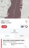
Also, this location does not show "all clear" on KittyHawk:
View attachment 124030
Wow! Thank you for that detailed reply. I was assuming he was below 400ft. I am from New York myself, but rarely go to Manhattan, so I didn’t realize the restriction in that specific area. I only checked downtown where there is a small area that has no restrictions. Your answer made me happy that I joined this forum because I’m always willing to learn new things. Thanks again mate!For starters, the DJI App is in no way able to be used as a reference for the legality of a flight. DJI sometimes lets you know that a TFR exists in an area, but the absence of a warning doesn't indicate that it's legal to fly in a location.
Next, that photo shows that the flight was clearly above 400 feet AGL, the maximum permissible altitude for UAS flights in the US (except for Part 107 pilots outside of controlled airspace, who remain within 400 feet of a structure >400 feet tall). You can easily tell this is >400 feet based on the similar altitude of One World Trade Center, which peaks out at around 1776 feet.
Also, that flight is over the Hudson River, and thus is taking place in the Hudson River SFRA. This is a highly trafficked air corridor next to Manhattan where the FAA has set forth special rules for operation in Part 93. If the drone is actually flying around 1776 feet, that is also firmly in Class B airspace at that location, which runs from 1300 feet to 7000 feet.
Also, this location does not show "all clear" on KittyHawk:
View attachment 124030
Wow! Thank you for that detailed reply. I was assuming he was below 400ft. I am from New York myself, but rarely go to Manhattan, so I didn’t realize the restriction in that specific area. I only checked downtown where there is a small area that has no restrictions. Your answer made me happy that I joined this forum because I’m always willing to learn new things. Thanks again mate!
We use essential cookies to make this site work, and optional cookies to enhance your experience.

