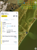
Looking at the sectional chart, that's in an Alert area where there is a high level of student jet training, but legally it is permissible to fly there without any additional airspace authorization.
If you are going to fly there, make sure you keep an eye out for any jet traffic in the area.