DJI Mavic, Air and Mini Drones
Friendly, Helpful & Knowledgeable Community
Join Us Now

Compass calibration second step?

I always recalibrate the compass at the beginning of every session no matter if it's 50 feet or 50 miles different. Magnetic lines of force are different than true north on a map known as magnetic declination. It varies throughout the world. Granted that a distance difference of a few miles shouldn't make any difference, but these magnetic lines are subject to change over time.

I have made it a practice to do three things prior to flight as part of my preflight.
1. Use a landing pad where practical.
2. Calibrate the compass.
3. Upon takeoff, hover at about 20 feet for about 15 seconds to give drone a good chance to "see" the landing area and memorize it.

Since I have started doing this, when doing a RTH the drone ALWAYS has landed within an inch or two of the takeoff position.
FYI - The compass does not compensate for magnet declination. I have pasted below a response from one of the resident gurus, SAR104, posted earlier this year that explains it very well.

“It cannot account for declination (the difference between magnetic north and true north) or deviation (the difference between magnetic north and the local magnetic field due to nearby magnetic objects) because it has no way to know the direction of true north except by reference to the magnetic field. It computes declination based on location from a global model of the earth's magnetic field that is in the firmware. Deviation cannot be determined by any method, and is the cause of many compass/yaw errors and uncontrolled flight.

The compass calibration is simply to measure and subtract the magnetic field of the aircraft itself, leaving just the external field. It measures it during the calibration process by separating the components of the magnetic field that don't change as you rotate the aircraft (the aircraft's magnetic field since that rotates with the aircraft) from the components that do change - the external magnetic field - that is assumed to be the earth's magnetic field.”
 
I always recalibrate the compass at the beginning of every session no matter if it's 50 feet or 50 miles different.
You are wasting your effort on a superstitious ritual
Magnetic lines of force are different than true north on a map known as magnetic declination. It varies throughout the world. Granted that a distance difference of a few miles shouldn't make any difference, but these magnetic lines are subject to change over time.
Compass calibration has nothing to do with magnetic declination.
You can travel thousands of miles without it making any difference to the calibration of your compass.
Since I have started doing this, when doing a RTH the drone ALWAYS has landed within an inch or two of the takeoff position.
Your autolanding accuracy is wholly due to the Precision Landing feature and has nothing to do with unnecessarily recalibrating the compass.

To gain an understanding of what compass calibration actually does rather than being mislead by myths, read the first post in this thread.
 
  • Like
Reactions: Kilrah
I always recalibrate the compass at the beginning of every session no matter if it's 50 feet or 50 miles different. Magnetic lines of force are different than true north on a map known as magnetic declination. It varies throughout the world. Granted that a distance difference of a few miles shouldn't make any difference, but these magnetic lines are subject to change over time.

I have made it a practice to do three things prior to flight as part of my preflight.
1. Use a landing pad where practical.
2. Calibrate the compass.
3. Upon takeoff, hover at about 20 feet for about 15 seconds to give drone a good chance to "see" the landing area and memorize it.

Since I have started doing this, when doing a RTH the drone ALWAYS has landed within an inch or two of the takeoff position.
Although there's no scientific proof that frequent compass calibration may harm the system, doing it prior to every flight seems to be an overkill. The issue was discussed to death since the birth of consumer droning and It was concluded by the most experienced pilots that the calibration should be performed as seldomly as possible. Every DJI flight monitoring app is offering compass reading indicator, either in form of acceptable values or - in simplified version - colour coded bars. This is the most reliable source of information in regards to compass sufficiency. Thing is that calibrating the compass in magnetically "polluted" environment - which one may be not aware of - can render more problems than not.

Sadly DJI never bothered to confirm nor deny the minimalistic approach of compass calibration. Instead, they introduced even more confusion by implementing forced (timed) calibration, despite clear indication that such is not really necessary.
 
Also regarding PL, no need to pause 15 seconds after vertical TO to 20ft.
Just be sure to go straight up at least 7ft before moving horizontally.

At least I think it's 7ft.
 
Last edited:
In the back of my mind I thought it might be meters. I tried looking that up but I guess the copy I have in One Drive is before PL was added.
 
Some folks may choose to turn the drone in their hands while rotating to calibrate. I do it a bit differently, holding it the whole time in one hand while doing "the calibration dance". Step one, while holding it flat turn your whole self to the left until it (the app) says to change positions, while continuing to do the anticlockwise dance. I continue turning to the left now pointing it to the sky until it tells me that calibration was successful. You could of course opt to turn it, changing hands as you remain stationary as it rotates on both planes, but other than maybe getting myself a bit dizzy from turning, I find it's a no-fuss, quick way to get the job done.
The calibration dance...me to. I did so recently when flying a water tower near a retirement community in Liverpool, NY. It was an impromptu flight when I was riding my ebike cruiser. I left my helmet (equipped with mirror and light atop) on while (dancing). When I finished, I immediately flew up and started my video...10 seconds later a couple of ladies in a van pulled up and asked if I knew where I was. I figured anti-droners...here we go. They then asked if I needed help and If I was OK. In retrospect: Bike parked off the side of the road, MM2 take off was from the shielded, field side of the bike and me with my (helmet) on, doing the circle dance...as they drove off perplexed, it dawned on me that they probably thought I was outside without supervision that I may have needed wearing the helmet and all. I had a good laugh because at first I had no idea why they stopped. Ahhhh...too funny.
 
  • Haha
Reactions: vindibona1
Hi all.

Setting up my new mavic 2 pro and need some advice on the second step of the compass calibration.

I complete the first step then it asks me to face the drone front down to the ground yet the image demonstration displayed shows the drone vertical on its side?

So do I calibrate the second step with the drone vertical on its side as the illustration shows or face down as the text shows?

Many thank
Usually it's nose pointing down for the 2nd step for DJI and Litchi. Sometimes you have to go a little farther than 360 deg
 
  • Like
Reactions: Thomas B
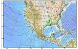
Some here have stated that changing locations has no effect on compass calibration but in fact location can have a significant effect since the compass in most drones is magnetic and the earth's magnetic field changes with location and even time. Here's a magnetic declination plot for the US and you can see that if one were to calibrate in Washington state and then move to Maine, compass readings would be off by quite a bit. If there are small locational changes (especially if it's in the direction of a field line), then these differences will be small or insignificant, but they do exist. On top of that, this map will change with time (the map shown is a 2010 map) because the molten interior of the earth moves, altering the external magnetic field. Of course, there are minute variations in these field lines due to local magnetic effects such as iron objects or deposits of iron in the earth.

Not that it's important here, but the earth's field has a vertical component (perpendicular to the earth's surface) also. You can measure that if you have an electronic compass sensitive along one axis (like a drone), and it too, undergoes changes with location and time.
 

Attachments

  • Magnetic Deviations.jpg
    Magnetic Deviations.jpg
    337 KB · Views: 7
Some here have stated that changing locations has no effect on compass calibration but in fact location can have a significant effect since the compass in most drones is magnetic and the earth's magnetic field changes with location and
This is a common misconception.
Compass calibration has nothing at all to do with where you are in the world and moving any distance makes no difference to your compass calibration.
Compass calibration does just one thing.
Read the first post of this thread to get a detailed explanation of what compass calibration really does (and what it cannot do).
 
Some here have stated that changing locations has no effect on compass calibration but in fact location can have a significant effect since the compass in most drones is magnetic and the earth's magnetic field changes with location and even time. Here's a magnetic declination plot for the US and you can see that if one were to calibrate in Washington state and then move to Maine, compass readings would be off by quite a bit. If there are small locational changes (especially if it's in the direction of a field line), then these differences will be small or insignificant, but they do exist. On top of that, this map will change with time (the map shown is a 2010 map) because the molten interior of the earth moves, altering the external magnetic field. Of course, there are minute variations in these field lines due to local magnetic effects such as iron objects or deposits of iron in the earth.

Not that it's important here, but the earth's field has a vertical component (perpendicular to the earth's surface) also. You can measure that if you have an electronic compass sensitive along one axis (like a drone), and it too, undergoes changes with location and time.
Magnetic declination differences are handled by a calculation in the drone firmware using the GPS coordinates. It is independent of the compass calibration.
 
Lycus Tech Mavic Air 3 Case

DJI Drone Deals

New Threads

Forum statistics

Threads
131,095
Messages
1,559,758
Members
160,078
Latest member
svdroneshots