DJI Mavic, Air and Mini Drones
Friendly, Helpful & Knowledgeable Community
Join Us Now

Confused - Flight Restricted Zone - FAA Area [NOT =] DJI No Fly Area - DJI Mini 2

WackeDad

Well-Known Member
Joined
Jan 2, 2022
Messages
57
Reactions
76
Age
74
Location
Pacific NW USA
I have property in the Puget Sound region of Washington State. My property is on a peninsula bordering a National Security UAS Flight Restrictions area. It's an ingress/egress waterway for Trident submarines. Be that as it may, according to the FAA publication, you can request authorization from the Coast Guard Sector Command Center by means of a phone call. So far so good.

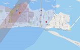
My challenge is that the zones indicated on the various maps do not line up. For example, both the FAA and the B4UFLY zone maps are virtually identical, and in fact mirror the coastline in front of my property. However, the DJI Geo Zone map cuts a straight swath hundreds of yards behind my property and nowhere near close to the other maps. So essentially, if a submarine passes in the waterway, UAS vehicles cannot be within 3000 feet laterally, and 1000 feet vertically. So, if you see a submarine approaching you ground your aircraft. Pretty simple. Where I am confused is, do I still need to get permission from the FAA when the Coast Guard has already given me clearance? In addition, because of the engineered "NO FLYING FOR YOU" safeguards, do I need to also secure a DJI 'hall pass' to take an excursion flight - sans submarines?

TIA
 
My understanding is that in a restricted zone you need the OK from the controlling authority. Do you have a way to document your OK from the Coast Guard Command Center ?

I am not sure how dji unlocks the no fly lock.
 
My understanding is that in a restricted zone you need the OK from the controlling authority. Do you have a way to document your OK from the Coast Guard Command Center ?

I am not sure how dji unlocks the no fly lock.
Good question. I haven't called yet, and inasmuch as it's a phone call, might just be the honor's system. Crazy thing is, before all the DOD security measures, we could run out little skiff out into the channel and wave to the crew on the bridge. Different times.
 
Might this break down into two separate question and answers, i.e,
1) what do you need to do to fly legally along with where can you fly legally?
2) what does DJI need you to do to be able to fly and what boundaries does it put in place?
If so, irrespective of the law and legal permissions granted by the Coast Guard, clashing with 2 is likely to ground you are be a boundary you can not cross.
i.e. to actually fly you'd have to satisfy 2) first before 1) becomes a possible 'concern'.

Or am I up a Gum Tree?
.
#2 is the challenge. DJI, it appears, has drawn an arbitrarily unrealistic boundary, far from the actual FAA definition. It’s that inaccuracy that I am questioning.

I suppose a third question comes into play; Will DJI modify their boundaries if factual clarification is provided?
 
We've posted this a bunch of time, but since not everyone reads every thread, lets do it again....
The DJI Geo Restrictions is not and is not meant to be equivalent to where you can legally fly. FAA classified, restricted, prohibited, etc air space is the law. DJI designed their zones to try to prevent incidents and generally keep people out of trouble. In some cases this matches exactly the FAA area. In some it is less restricted, and it others it is more. You can see this around lots of airports that have authorization zones that are bigger or smaller than the classified airspace and altitude zones in line with the runways, even if they are in Class G airspace.

You need FAA clearance (or if the FAA says Coast Guard, then them, I guess) to legally fly. You need DJI to allow your bird to physically fly. These are different process and as noted may not match.

If you think the DJI space is totally off, send them an email [email protected] and I would include the FAA maps to help your case. People have gotten things corrected, although it seems to take a while for it to happen.

Good luck, I hope it eventually gets sorted for you...
 
We've posted this a bunch of time, but since not everyone reads every thread, lets do it again....
Sorry…I searched as best I could. Great information. I’ll be reaching out to the Coast Guard shortly. The County where the naval base is located isn’t too concerned so long as the 3000 ft lateral space is adhered to. I was just concerned that the drone couldn’t even get close to the beach/cliff because of the programmed GEO fence. Weathers is crap so I still need to test it all out.
Thanks
 
We've posted this a bunch of time, but since not everyone reads every thread, lets do it again....
The DJI Geo Restrictions is not and is not meant to be equivalent to where you can legally fly. FAA classified, restricted, prohibited, etc air space is the law. DJI designed their zones to try to prevent incidents and generally keep people out of trouble. In some cases this matches exactly the FAA area. In some it is less restricted, and it others it is more. You can see this around lots of airports that have authorization zones that are bigger or smaller than the classified airspace and altitude zones in line with the runways, even if they are in Class G airspace.

You need FAA clearance (or if the FAA says Coast Guard, then them, I guess) to legally fly. You need DJI to allow your bird to physically fly. These are different process and as noted may not match.

If you think the DJI space is totally off, send them an email [email protected] and I would include the FAA maps to help your case. People have gotten things corrected, although it seems to take a while for it to happen.

Good luck, I hope it eventually gets sorted for you...
 
There's a good example of DJI's geo-fencing failing to adequately inform the user at Kessler AFB, KBIX, in Biloxi Mississippi. If you rely on DJI you can fly nearly 2.5 miles into Class D airspace where LAANC is not available. You can't trust DJI's system to keep you in the clear.

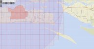
DJI's system fails badly around military airbases. I've found several examples on the Gulf coast. The airbases appear with a typical circle and grid on the FAA SUAS map, but LAANC is not active, so you can't get authorization to fly anywhere inside the circle. DJI locks out only a smaller area around the base and the approaches, but drops the ball elsewhere in the FAA's circle. So if you take DJI's word, you might be mixing it up with some pretty serious military hardware run by a group that doesn't take such incursions lightly.

DJI

dji1.jpg

FAA

FAA.jpg

You can't rely solely on DJI geo-fencing. They even tell you so. Note their disclaimer and warning. (Emphasis added.)

"The GEO system is advisory only. Each user is responsible for checking official sources and determining what laws or regulations might apply to his or her flight. In some instances, DJI has selected widely-recommended general parameters without making any determination of whether this guidance matches regulations that may apply specifically to you."


  • Like
Reactions: WackeDad
Thank you to all who provided very thorough and thoughtful replies. I will follow up this thread once I get a full update from the authorities and powers that be. Silly, but all I want to do is get a spectacular sunset over the Olympic Mountain Range on the Washington West side.
 
  • Like
Reactions: z28lt1
Per @z28lt1 I decided to pursue this a little further. I actually drove over to the property and area in question so I could get actual screen shots from the Fly App as well as map coordinates where the DJI GEO Fence releases its death grip. I ended up contacting the Coast Guard Command office at the phone number listed in the FAA restriction map. My call wasn’t his first rodeo and needless to say, he told me they have zero control over that flight zone, or ANY flight zone.

So I gathered all my 8x10 glossy photos and maps with zone discrepancies (think “Alice’s Restaurant”) and sent an email to flysafe@dji. My bet is the result won’t turn out like it did for Arlo Guthrie, but at least I tried. I did find a fellow pilot on Reddit with the exact same issue in the exact same location, but there was no followup with their challenge.

Once again I’ll report back my results. Although to be honest (put your tea and drinks down), with all the Chinese characters at the bottom of the reply, I probably don’t stand a “C….man’s Chance”.
 
Then the judge came in - with his seeing eye dog....;) Don't be surprised if DJI gives you the run-around, but I hope you get your problem solved... seems persistence and patience has helped a lot of folks get through to them.

Have you yet tried to fly inside the DJ I demarcation? Or maybe even to arm the motors just to see if it'll crank up?
 
  • Like
Reactions: WackeDad
Have you yet tried to fly inside the DJ I demarcation? Or maybe even to arm the motors just to see if it'll crank up?
<blush> I did not. I'm very new to the Mini 2 and 'assumed' (you know the rest) that the mere fact the app displayed in a big red blob at the top of the screen "Restricted Z...". It didn't occur to me to do that. However, the other pilot in my area has attempted to get a release from DJI but it takes to long and he can't do his assigned photo assignment. So it seems that based on your Controller SN DJI has a way of permitting it. IMHO they need to change their boundary on the map, for everyone, not just those of us who are tenacious.
 
…a few hours later… I’ve contacted DJI via [email protected] and was pleasantly surprised that I received a reply after supplying them with my Controller serial number. They provided me with a 3 month code that gives me a 1000 meter radius to fly from my home point. This will be fine for now.

Regarding the GEO zone issue, visit the following link and submit the feedback request for modifying the GEO map.

https://fly-safe.dji.com/account-manage/feedback-manage/list

Choose “Location Closed Or Does Not Exist” in the request. Be sure to provide official files/pictures/websites as proof.

I suspect the more detail the better. They did say that if a change is made to the GEO map, it could take some time to filter down to the app. I’m thinking this is where you get several pilots to add to the petition for better results. In my case it’s the problem of their restricted zone not even closely relating to FAA/Aloft/B4UFLY/AirMap maps (which all line up).

Cheers
 
Regarding the GEO zone issue, visit the following link and submit the feedback request for modifying the GEO map.

https://fly-safe.dji.com/account-manage/feedback-manage/list

Choose “Location Closed Or Does Not Exist” in the request. Be sure to provide official files/pictures/websites as proof
Thanks for the info and the link... I'll try that.

Good friend of mine owns 200 acres in a very rural area, no neighbors within a mile of his house in any direction, his house is at the top of a hill with a great view of all his property from the front yard - a great place to fly.... and yet dji's Geo map shows a helipad less than half mile from his house in the middle of a dense forest. I have to take the enhanced Geo warning quiz every time I fly there. For now it's just a slight pita, but it bothers me that DJI could lock it down even further in the future.

I've tried to get it removed several times and several different ways since 2017, contacting DJI the FAA etc etc... no luck.
 
Lycus Tech Mavic Air 3 Case

DJI Drone Deals

Forum statistics

Threads
134,438
Messages
1,594,777
Members
162,975
Latest member
JNard1