There are a couple of videos that hint that the pattern recognition software used by DJI is based on a system of adjacent triangles with distinctive features at the vertices of the triangles. So I found an old scrap of plastic countertop material and used 2-inch wide contrasting tape to make an arrow shape in the middle surrounded by three dots of tape at unequal distances, which would form the vertices of unique triangles. I placed the drone above the arrow and made small circles around the feet, so I could accurately measure the difference between landing and takeoff positions.
Then I made about 3 dozen Return to Home and Precision Landings to compare my homemade landing pad to a commercial landing pad with a symmetric pattern. I believe that the Precision Landing software takes photos at several heights using the Vision Positioning System cameras on the bottom of the drone. So during takeoff I slowly ascended to a height of 50 feet before flying away.
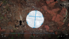
The results were interesting. The least accurate Precision Landings were made with the landing pads on a parking lot, followed by landings on the sidewalk in front of my house. But the most accurate landings were made with my homemade landing pad placed on a 5 foot square of paving stones beside a shed in my back yard. The most accurate Precision Landing was about 1 inch away from the takeoff position using an Autel Evo.
The pattern on the landing pad may not be as important as the surroundings. The visual Positioning System probably uses the wide angle camera lenses and the pattern recognition algorithms that relies on easily recognized features. From an altitude of 30 to 50 feet the landing pad image may look like a dot. A uniform parking lot dosn’t have a lot of distinctive features, and the Precision Landings were the least accurate. The paving stones next to the shed between two trees had the most easily recognized features and gave the most accurate Precision Landings.