You are using an out of date browser. It may not display this or other websites correctly.
You should upgrade or use an alternative browser.
You should upgrade or use an alternative browser.
DJI Air 3 compatibility
- Thread starter Mineslab
- Start date
You use the DJI Fly app & it's waypoint mode...
Check this out --> Introduction to Waypoint Flight Mode of DJI Fly
Check this out --> Introduction to Waypoint Flight Mode of DJI Fly
- Joined
- Jun 8, 2020
- Messages
- 1,779
- Reactions
- 2,537
- Age
- 68
- Location
- Red Head , NSW, Australia 🇦🇺
- Site
- youtu.be
Hi,Is there any software other than DJI Fly in which DJI Air 3 can be fly
If there is no software then how to do waypoint planning in DJI Air
This is a "heads up" to be cautious when flying a preplanned waypoint mission, as altitudes can change from what you originally set!
Page 41 of the Air 3 manual states - "THE FLIGHT ROUTE WILL CURVE BETWEEN WAYPOINTS, SO THE AIRCRAFT ALTITUDE BETWEEN WAYPOINTS MAY BECOME LOWER THAN THE ALTITUDES OF THE WAYPOINTS DURING THE FLIGHT. MAKE SURE TO AVOID ANY OBSTACLES BELOW WHEN SETTING A WAYPOINT"
Recently I almost lost my Air 3 into the ocean because of this. This was due to a negative altitude being implemented by the waypoint flight that was not known until actually flying the mission. @KenGhas had a similar issue, with DJI confirming that a new core board module was needed for his Air 3 and are replacing it under warranty.
Here is a short fun video of what happened in my case utilising my AirData stats. You can see how I was climbing nicely until suddenly at waypoint F a negative altitude is applied. In a state of panic I hit RTH with a second to spare. Enjoy!
Waypoints Mission (Impossible)-4K.mov
A VERY CLOSE call.Hi,
This is a "heads up" to be cautious when flying a preplanned waypoint mission, as altitudes can change from what you originally set!
Page 41 of the Air 3 manual states - "THE FLIGHT ROUTE WILL CURVE BETWEEN WAYPOINTS, SO THE AIRCRAFT ALTITUDE BETWEEN WAYPOINTS MAY BECOME LOWER THAN THE ALTITUDES OF THE WAYPOINTS DURING THE FLIGHT. MAKE SURE TO AVOID ANY OBSTACLES BELOW WHEN SETTING A WAYPOINT"
Recently I almost lost my Air 3 into the ocean because of this. This was due to a negative altitude being implemented by the waypoint flight that was not known until actually flying the mission. @KenGhas had a similar issue, with DJI confirming that a new core board module was needed for his Air 3 and are replacing it under warranty.
Here is a short fun video of what happened in my case utilising my AirData stats. You can see how I was climbing nicely until suddenly at waypoint F a negative altitude is applied. In a state of panic I hit RTH with a second to spare. Enjoy!
Waypoints Mission (Impossible)-4K.mov
Dale
I don't believe that the sensors on the DJI drones are sensitive to water. I heard that from a friend AFTER I accidentally plunged my first DJI into a lake.Wouldn't obstacle avoidance prevent the aircraft from submerging into the ocean?
I guess water can be more or less opaque at different times depending on the circumstances.
I wonder if the sensors would detect the blue walls and floor of a pool. The water is totally clear but it looks blue from above, though maybe the OA would think the solid object is on the floor of the pool and not recognize the 6 feet of water above the floor.
I wonder if the sensors would detect the blue walls and floor of a pool. The water is totally clear but it looks blue from above, though maybe the OA would think the solid object is on the floor of the pool and not recognize the 6 feet of water above the floor.
Point F seems appropriate for what happened. More like WTFHi,
This is a "heads up" to be cautious when flying a preplanned waypoint mission, as altitudes can change from what you originally set!
Page 41 of the Air 3 manual states - "THE FLIGHT ROUTE WILL CURVE BETWEEN WAYPOINTS, SO THE AIRCRAFT ALTITUDE BETWEEN WAYPOINTS MAY BECOME LOWER THAN THE ALTITUDES OF THE WAYPOINTS DURING THE FLIGHT. MAKE SURE TO AVOID ANY OBSTACLES BELOW WHEN SETTING A WAYPOINT"
Recently I almost lost my Air 3 into the ocean because of this. This was due to a negative altitude being implemented by the waypoint flight that was not known until actually flying the mission. @KenGhas had a similar issue, with DJI confirming that a new core board module was needed for his Air 3 and are replacing it under warranty.
Here is a short fun video of what happened in my case utilising my AirData stats. You can see how I was climbing nicely until suddenly at waypoint F a negative altitude is applied. In a state of panic I hit RTH with a second to spare. Enjoy!
Waypoints Mission (Impossible)-4K.mov
I'm not saying this is the only reason the altitude would change, but a big one. Your altitude is relative to you take off point. The Way points recorded are from you AGL distance from the take off point. So your last take of point is busy, occupied, whatever and you take off from a different point which has a different MSL, then your altitudes will all be off by the relative distance. Which probably isn't a big deal if you take off from a higher point, you just wont be able to seemlessly blend your waypoint flight over time. However, if you take off from a lower MSL point than your original launch point and waypoint mission you could have a very bad day.


No option in DJI fly app to do this, which controller to be used?You use the DJI Fly app & it's waypoint mode...
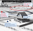
Check this out --> Introduction to Waypoint Flight Mode of DJI Fly
First of all you need to have a drone that have DJI's native waypoint mission mode... as the Air 3, not all drones using DJI Fly have that.No option in DJI fly app to do this, which controller to be used?
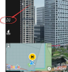
Then just this...

I have recently purchased Air 3 . This waypoint icon is not showingFirst of all you need to have a drone that have DJI's native waypoint mission mode... as the Air 3, not all drones using DJI Fly have that.
Then just this...
View attachment 175722
Droning on and on...
Well-Known Member
I have recently purchased Air 3 . This waypoint icon is not showing
Have you flown it yet?
Stupidly, the waypoint feature isn't activated in DJI Fly until you Pair the A3 with the controller, then fly it and create your first WP mission in flight.
Only after that can you turn on the controller and access the feature without the A3 also powered up and connected.
Maybe not so stupidly. Blindly creating waypoint missions on the ground without first establishing that you know how to fly while also creating one is probably ill advised. That safety feature should, however, be documented. Is it?
If you have already met the above stated minimum requirements, it should be available regardless of which controller and display device you are using.Do I need the RC2 controller or without display controller with my mobile is also fine.
Droning on and on...
Well-Known Member
Maybe not so stupidly. Blindly creating waypoint missions on the ground without first establishing that you know how to fly while also creating one is probably ill advised. That safety feature should, however, be documented. Is it?
While you make a valid point, I stand by my judgement that this implementation is stupid.
Standard UI practice (evolved over decades of experience and feedback, this is stuff of basic UI classes) you don't hide disabled features. You use additional feedback/cues to the user the feature is disabled. A popup, grayed out selection, selection in italics, etc.
Otherwise, EXACTLY the kind of confusion results as we're seeing here.
In this case, a popup explaining the situation would be a good choice.
is there any software to do waypoint planning for DJI Air 3If you have already met the above stated minimum requirements, it should be available regardless of which controller and display device you are using.
is there any software to do waypoint planning for DJI Air 3First of all you need to have a drone that have DJI's native waypoint mission mode... as the Air 3, not all drones using DJI Fly have that.
Then just this...
View attachment 175722
Similar threads
- Replies
- 2
- Views
- 1K
- Replies
- 40
- Views
- 12K
- Replies
- 13
- Views
- 9K
DJI Drone Deals
New Threads
-
-
-
-
-
The FCC ban on all foreign made UAS and UAS "critical components"
- Started by anotherlab
- Replies: 13


