DJI Mavic, Air and Mini Drones
Friendly, Helpful & Knowledgeable Community
Join Us Now

DJI Air 3 - Waypoint Mission Crash into sea

JNB

Member
Joined
Feb 27, 2024
Messages
10
Reactions
13
Location
UK
Hi,

I am hoping for some help with a crash that happened when flying my DJI Air 3 on a Waypoint mission.

I had setup a simple Waypoint mission (Start at point A – fly to point B at a constant height, then RTH) and flown it successfully once. I then flew it again (after sunset) but this time my drone descended rapidly and crashed into the sea. The waypoint started at 67ft above takeoff point which was on a cliff above the sea approx. 30 to 40ft high (my estimate). When I started the waypoint mission, I was climbing on some rocks to ensure I kept the drone in sight so wasn’t paying full attention to the drone and only noticed it was descending at the last minute – I tried to push the left stick up to gain height, but it was just too late and it hit some rocks and crashed into the sea and was unrecoverable. Looking at the logs, it started descending right after take off and I don’t understand why.

If anyone could provide some insight as to why it decided to start descending during the waypoint mission I would be grateful.

I logged a case with DJI and they are saying that I should expect the drone to “curve” between waypoints and this is expected behaviour and there was no aircraft malfunction found during the flight – obviously I don’t agree with this.

Couple of points to note: it was dark and the Vision and Obstacle Sensing was unavailable (I received and understood this message on startup) and drone required a compass calibration just before the flight.

I have uploaded the .TXT data file and the .KMZ waypoint file to OneDrive (link)

I uploaded the .TXT data file to PhantomHelp (link)
 
  • Like
Reactions: RodPad
Hi there & welcome to the forum 👋

The .txt log just confirms that the barometric height decreases once starting the autonomous waypoint mission... all different data regarding the change in height agrees, so this doesn't look like some IMU failure.

The problem here is that we can't compare the .TXT data with how the drone was commanded as we don't have any stick inputs (obviously) & we don't know how you had designed the waypoint mission... any possibility to share a native DJI Fly app waypoint mission so it can be investigated without the Fly app?

As a side note... we have had some cases here at the forum that claims that the height have changed (descended) without support in the waypoint mission.
 
  • Like
Reactions: RodPad and JNB
Hi there & welcome to the forum 👋

The .txt log just confirms that the barometric height decreases once starting the autonomous waypoint mission... all different data regarding the change in height agrees, so this doesn't look like some IMU failure.

The problem here is that we can't compare the .TXT data with how the drone was commanded as we don't have any stick inputs (obviously) & we don't know how you had designed the waypoint mission... any possibility to share a native DJI Fly app waypoint mission so it can be investigated without the Fly app?

As a side note... we have had some cases here at the forum that claims that the height have changed (descended) without support in the waypoint missi
Hi,

The .KMZ file in the OneDrive link above is the waypoint file I transferred from my DJI RC 2 controller. I this what you mean by "native DJI Fly app waypoint mission"?
 
Hi,

The .KMZ file in the OneDrive link above is the waypoint file I transferred from my DJI RC 2 controller. I this what you mean by "native DJI Fly app waypoint mission"?
Your kmz file doesn't appear to contain any spatial data.
 
  • Like
Reactions: RodPad
Hi,

The .KMZ file in the OneDrive link above is the waypoint file I transferred from my DJI RC 2 controller. I this what you mean by "native DJI Fly app waypoint mission"?
As said... that file doesn't contain anything I can read, maybe it's only readable from the Fly app?
 
  • Like
Reactions: RodPad
@JNB
Welcome to the forum!

Seeing the members names already posted.
Pretty sure they all know I just have questions and no answers.

Your first post is today, the files on the drive appear to be the 2/16/2024?

To all is there way for me to see a DJI Fly app mission, like I'm used to with Litchi mission hub?

Rod ..
 
  • Like
Reactions: JNB
No ... it's an empty file with no spatial data.
@slup @Meta4 That is the only file that I found in the waypoints folder on the DJI RC 2. Is there another file that you are talking about? Can you give me the filename and location and I can get it uploaded?
 
  • Like
Reactions: RodPad
@JNB
Welcome to the forum!

Seeing the members names already posted.
Pretty sure they all know I just have questions and no answers.

Your first post is today, the files on the drive appear to be the 2/16/2024?

To all is there way for me to see a DJI Fly app mission, like I'm used to with Litchi mission hub?

Rod ..
@RodPad the crash happened on Feb, 16 - I have been back and forward with DJI Support over the past week or so trying to get a resolution, but they keep insisting there wasn't a problem with the drone. I joined the forum to try and use the expertise here to get some further insight to help with my case.
 
@slup @Meta4 That is the only file that I found in the waypoints folder on the DJI RC 2. Is there another file that you are talking about? Can you give me the filename and location and I can get it uploaded?
A kmz file should have waypoint data in it, but that one is empty.
I joined the forum to try and use the expertise here to get some further insight to help with my case.
There's a lot more that can be done to solve flight mysteries for manual flights.
But with a waypoint flight, it's very difficult as there are no joystick inputs to see and without knowing what the flight was programmed to do, there's not much to work with.
 
  • Like
Reactions: RodPad and JNB
A kmz file should have waypoint data in it, but that one is empty.

There's a lot more that can be done to solve flight mysteries for manual flights.
But with a waypoint flight, it's very difficult as there are no joystick inputs to see and without knowing what the flight was programmed to do, there's not much to work with.
Thanks makes sense @Meta4, thanks!

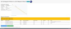
The .KMZ file in the OneDrive link has some data in it - you can unzip with with WinZip and it has two files: template.kml and waylines.wpml and these have the data points for the waypoint mission. I also uploaded the .KMZ to DJI Fly Waypoint Mission to Litchi Waypoint Mission and it shows this:

2024-02-16 - Visual of Waypoint Mission (litchiutilities.com).jpg

Points 1 and 2 were the waypoints I set and I assume 3 and 4 are for the RTH points (I didn't set these) - the start point (1) was behind me and 4 looks like the take off location

Does this help in any way?
 
  • Like
Reactions: RodPad
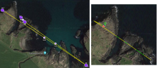
Sorry... but can't stop suspecting that this with converting your DJI Fly waypoint mission to something we can see through that converter, hides some crucial facts... I mean, from where does those 2 last waypoints come from, they aren't directed to the recorded HP... & doesn't mark the HP either?

Below to the right, the .txt log shown in PhantomHelp, with the HP marked... & to the left the converted DJI Fly waypoint mission shown in the Litchi hub. What more is missing or is wrongly interpreted in the converting process?

Can't say anything conclusive I'm afraid.

Have you checked that waypoint 2 actually have a set height in DJI Fly... and not just zero or blank, which the converter maybe interpret as "continue with the same height as waypoint 1"?

1709132404482.png
 
  • Like
Reactions: RodPad and JNB
Sorry... but can't stop suspecting that this with converting your DJI Fly waypoint mission to something we can see through that converter, hides some crucial facts... I mean, from where does those 2 last waypoints come from, they aren't directed to the recorded HP... & doesn't mark the HP either?

Below to the right, the .txt log shown in PhantomHelp, with the HP marked... & to the left the converted DJI Fly waypoint mission shown in the Litchi hub. What more is missing or is wrongly interpreted in the converting process?

Can't say anything conclusive I'm afraid.

Have you checked that waypoint 2 actually have a set height in DJI Fly... and not just zero or blank, which the converter maybe interpret as "continue with the same height as waypoint 1"?

View attachment 173024
"Have you checked that waypoint 2 actually have a set height in DJI Fly... and not just zero or blank, which the converter maybe interpret as "continue with the same height as waypoint 1"?"

Unfortunately, I can't see the waypoint missions on the DJI RC 2 controller without connecting to the aircraft.

Those last two waypoints are weird - I only set two when creating the waypoint mission - the start and the end points. The waylines.wpml looks like it contains all the data, but it is in a markup language that is difficult to parse out and understand.
 
  • Like
Reactions: RodPad
"Have you checked that waypoint 2 actually have a set height in DJI Fly... and not just zero or blank, which the converter maybe interpret as "continue with the same height as waypoint 1"?"

Unfortunately, I can't see the waypoint missions on the DJI RC 2 controller without connecting to the aircraft.

Those last two waypoints are weird - I only set two when creating the waypoint mission - the start and the end points. The waylines.wpml looks like it contains all the data, but it is in a markup language that is difficult to parse out and understand.

@JNB: You should be able to see the WP mission w/o connected AC by accessing the WP directory on your DJI RC 2:
Hit Tutorial (lower right corner) - Camera view (upper right corner) - WP Function (left side in the middle) - Directory symbol (left to middle, lower third).

All WP missions are stored here and you can retrieve all required details manually.
So far, I have not tried to extract or download the WP files.
 
Last edited:
  • Like
Reactions: RodPad and JNB
If anyone could provide some insight as to why it decided to start descending during the waypoint mission I would be grateful.
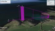
I have had a look at your DJI Fly waypoint mission (the KMZ file). Here is a 3D view of it if it had been flown using Litchi. I know you did not use Litchi but I said this for a reason which I will explain later.
Capture.JPG

The waypoint file contains four waypoints. Here is the most important spacial data of those four points:

<Point>
<coordinates>
-6.44208038643327,55.2396759481054
</coordinates>
</Point>
<wpml:index>0</wpml:index>
<wpml:executeHeight>15.7</wpml:executeHeight>

<Point>
<coordinates>
-6.43634633331181,55.2374968389514
</coordinates>
</Point>
<wpml:index>1</wpml:index>
<wpml:executeHeight>15.7</wpml:executeHeight>

<Placemark>
<Point>
<coordinates>
-6.44054121709631,55.2392019874067
</coordinates>
</Point>
<wpml:index>2</wpml:index>
<wpml:executeHeight>116.1</wpml:executeHeight>

<Placemark>
<Point>
<coordinates>
-6.44079743904627,55.2393787417469
</coordinates>
</Point>
<wpml:index>3</wpml:index>
<wpml:executeHeight>119.1</wpml:executeHeight>

The height of the first two waypoints are set to 15.7 meters. The height of the last two waypoints are set to almost 120 meters. The placement of the four waypoint in conjunction with their heights make this mission execute in an almost vertical plane.

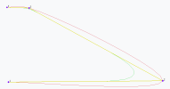
Had this mission been flown using Litchi, the entire mission would have been flown within the convex hull defined by the four waypoints. However, you used DJI Fly. DJI Fly uses a Catmull-Rom spline to create the flight path from those waypoints. A Catmull-Rom spline does not have the convex hull property.

My best guess as to what happened is this:

1. Your first two waypoints were configured to be at the same height above takeoff.
2. Because the last two waypoints were so much higher, the flight path went below the height of waypoint 2 as it approached waypoint 2 in order to make a smooth curve up to the last two higher waypoints.

The photo below illustrates how a Catmull-Rom spline passes through the waypoints in your flight.
Capture.PNG
 
I have had a look at your DJI Fly waypoint mission (the KMZ file). Here is a 3D view of it if it had been flown using Litchi. I know you did not use Litchi but I said this for a reason which I will explain later.
View attachment 173033

The waypoint file contains four waypoints. Here is the most important spacial data of those four points:

<Point>
<coordinates>
-6.44208038643327,55.2396759481054
</coordinates>
</Point>
<wpml:index>0</wpml:index>
<wpml:executeHeight>15.7</wpml:executeHeight>

<Point>
<coordinates>
-6.43634633331181,55.2374968389514
</coordinates>
</Point>
<wpml:index>1</wpml:index>
<wpml:executeHeight>15.7</wpml:executeHeight>

<Placemark>
<Point>
<coordinates>
-6.44054121709631,55.2392019874067
</coordinates>
</Point>
<wpml:index>2</wpml:index>
<wpml:executeHeight>116.1</wpml:executeHeight>

<Placemark>
<Point>
<coordinates>
-6.44079743904627,55.2393787417469
</coordinates>
</Point>
<wpml:index>3</wpml:index>
<wpml:executeHeight>119.1</wpml:executeHeight>

The height of the first two waypoints are set to 15.7 meters. The height of the last two waypoints are set to almost 120 meters. The placement of the four waypoint in conjunction with their heights make this mission execute in an almost vertical plane.

Had this mission been flown using Litchi, the entire mission would have been flown within the convex hull defined by the four waypoints. However, you used DJI Fly. DJI Fly uses a Catmull-Rom spline to create the flight path from those waypoints. A Catmull-Rom spline does not have the convex hull property.

My best guess as to what happened is this:

1. Your first two waypoints were configured to be at the same height above takeoff.
2. Because the last two waypoints were so much higher, the flight path went below the height of waypoint 2 as it approached waypoint 2 in order to make a smooth curve up to the last two higher waypoints.

The photo below illustrates how a Catmull-Rom spline passes through the waypoints in your flight.
View attachment 173034
Quite comprehensive work!
The question is still: where do WP3 and 4 come from if the TA did not program it?
@JNB, maybe check out the WP file with related details on your DJI RC2 (see #15).
 
  • Like
Reactions: RodPad and JNB
I have had a look at your DJI Fly waypoint mission (the KMZ file). Here is a 3D view of it if it had been flown using Litchi. I know you did not use Litchi but I said this for a reason which I will explain later.
View attachment 173033

The waypoint file contains four waypoints. Here is the most important spacial data of those four points:

<Point>
<coordinates>
-6.44208038643327,55.2396759481054
</coordinates>
</Point>
<wpml:index>0</wpml:index>
<wpml:executeHeight>15.7</wpml:executeHeight>

<Point>
<coordinates>
-6.43634633331181,55.2374968389514
</coordinates>
</Point>
<wpml:index>1</wpml:index>
<wpml:executeHeight>15.7</wpml:executeHeight>

<Placemark>
<Point>
<coordinates>
-6.44054121709631,55.2392019874067
</coordinates>
</Point>
<wpml:index>2</wpml:index>
<wpml:executeHeight>116.1</wpml:executeHeight>

<Placemark>
<Point>
<coordinates>
-6.44079743904627,55.2393787417469
</coordinates>
</Point>
<wpml:index>3</wpml:index>
<wpml:executeHeight>119.1</wpml:executeHeight>

The height of the first two waypoints are set to 15.7 meters. The height of the last two waypoints are set to almost 120 meters. The placement of the four waypoint in conjunction with their heights make this mission execute in an almost vertical plane.

Had this mission been flown using Litchi, the entire mission would have been flown within the convex hull defined by the four waypoints. However, you used DJI Fly. DJI Fly uses a Catmull-Rom spline to create the flight path from those waypoints. A Catmull-Rom spline does not have the convex hull property.

My best guess as to what happened is this:

1. Your first two waypoints were configured to be at the same height above takeoff.
2. Because the last two waypoints were so much higher, the flight path went below the height of waypoint 2 as it approached waypoint 2 in order to make a smooth curve up to the last two higher waypoints.

The photo below illustrates how a Catmull-Rom spline passes through the waypoints in your flight.
View attachment 173034
@DJ Wes, thank you for this comprehensive explanation - I appreciate you taking the time to share this! It really helps my understanding!

@PeRo, thanks for the pointers to access the Waypoints on the RC 2 - I didn't know you could do that.

Based on the feedback provided by everyone that commented, I think I have an understanding what happened and how it happened, but I need to do a little more research and review the data in more detail before I can say for sure. Watch this space :)
 
PILOT ERROR

The two words none of us want to hear ☹ but in this case, I can say that my actions caused the crash (not intentionally, of course 😊).

The crash was caused by the drone flying a curve to intercept waypoints 3 and 4 (at 390ft above takeoff – max height) after flying what I thought was supposed to be a straight line between waypoints 1 and 2 (at 47ft above takeoff). The two extra waypoints at 390ft had puzzled me from the start – in a previous flight log, I setup a straight line waypoint mission and wanted to fly from point 1 to point 2 and return. I recall setting up the waypoints by setting point 1, flying to point 2 and setting it, I then flew the drone back to my location and initiated the waypoint mission. I stopped the first run as I realised the drone was flying too slowly and I had forgotten to set “record on” for point 1. I opened the waypoint settings, made the changes and started the waypoint mission again and it successfully ran from point 1 to point 2 then started an RTH. As it returned, I cancelled the RTH and manually flew back to my location to take a top down photo at max height and it is here that I believe the extra two waypoints occurred. I must have had the waypoint editor open and when I flew above, at 390ft, I would have pressed the C1 button to move the gimbal into a downward facing position to take the photo, but the C1 button also adds a waypoint in the waypoint editor – it looks like I pressed this twice as two additional waypoints were added (although I can’t recall this happening – I may have seen that it was still in waypoint edit mode and just closed it down after the C1 button presses). I landed after taking the photo and shut the drone down.

The next flight was to capture the waypoint mission in twilight / darkness and would have included the extra two waypoints and therefore would not have flown the same (as explained by @DJ Wes in post #16). The crash was caused by the flight between waypoints curving, the fact that it was dark and the vision sensors were not operating and that I was looking elsewhere when the crash was imminent. Multiple lessons learned 🤦‍♂️

Thanks to all that responded and shared their knowledge on this thread, it was much appreciated. Sometimes you win, sometimes you learn 👍
 
Lycus Tech Mavic Air 3 Case

DJI Drone Deals

New Threads

Forum statistics

Threads
131,132
Messages
1,560,143
Members
160,103
Latest member
volidas