DJI Mavic, Air and Mini Drones
Friendly, Helpful & Knowledgeable Community
Join Us Now

Dji Mavic 2 zoom lost signal an no auto RTH

Sully123

New Member
Joined
Jan 1, 2021
Messages
3
Reactions
0
Age
28
Location
Christchurch nz
while out flying today my Mavic 2 zoom lost connection while flying about 4 minutes in then the auto RTH did not work so I ended up loosing my drone I managed to get signal back to my drone for about 1 minute where it showed all flight data then disconnected again then ended up crashing my drone. when my drone disconnected it was hovering and not responding to me trying to reconnect. I rebooted my app and still nothing and my controller said signal lost I haven't had any troubles with this drone and it was set to RTH when signal lost so I have no idea why this has happen an nothing in the flight data looks off so im little confused to why this has happen

I also took the drone off from around 10m above sea level so most of the flight was at an altitude of around 15 meters in sports mode an in visual sight by a spotter with binoculars checking a river mouth for fishing

064C049A-F341-43EA-8CCE-7A8212EE0CC6.jpeg


Attachments

  • DJIFlightRecord_2021-01-02_[09-47-41].txt
    385.9 KB · Views: 12
while out flying today my Mavic 2 zoom lost connection while flying about 4 minutes in then the auto RTH did not work so I ended up loosing my drone.
Losing signal doesn't cause drones to be lost.
It would normally trigger RTH.
Your recorded flight data suggests a possible reason for the drone not coming back.
I managed to get signal back to my drone for about 1 minute where it showed all flight data then disconnected again then ended up crashing my drone. when my drone disconnected it was hovering and not responding to me trying to reconnect.
It would be very interesting to see the recorded data that shows this, but it's not in the file you attached.
I have no idea why this has happen an nothing in the flight data looks off so im little confused to why this has happen
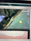
The flight data shows you flying the Mavic sideways in Sport Mode at 67 km/h and approximately 6 metres above the launch point.

i-Z8dT4fS-L.jpg


The flight path shows that you flew up over the water and turned back to fly towards home inland of the coast.
You flew toward a ridge and lost signal when the ridge blocked the signal.
The yellow line on the Google Earth view is the straight line between the point of loss of signal and the home point.

The ridge that blocked signal was 10 metres higher than the home point + the height of the trees.
With the drone only 6 metres higher than the launch point and flying fast, it would have taken some time to come to a stop after losing signal.
Flying sideways you wouldn't have seen what what the drone was about to run into.
It looks like it probably crashed into the ridge or trees very soon after losing signal.

The crash would have happened very soon after signal was lost before it had a chance to start returning to home.
 
Last edited:
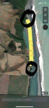
thank you for reply. the data does suggest a crash but once I did get reconnection briefly before it losing signal again my drone was hovering looking north east out to the ocean I have looked for flight data but nothing an went to try find the drone today an was not round where it said. As soon as I was banking round to check the river mouth and went past that headland that's where I ran into problems but I let off controls and when I did reconnect it was hovering but not responding so giving me the impression it did not crash till battery ran dead. I swam across the river an walked down to try get it back on but by that time it had crashed. It my be my fault I just want to know if there's anything more I can do to try get data from when it reconnected because with out that it does look like I crashed but my last images I got were the drone hovering still. thank you F0CEE5AD-5541-4A10-BD75-A569CFB4A5D1.jpeg
 
Restarting the app doesn't force trigger failsafe since the RC would still be linked. Powering off the RC would force break the link and trigger failsafe.
There are some circumstances that the AC transmission is lost by the RC, but the AC still receives the RC transmission. That happened to me once with my P3A, which I could prove by comparing the logs on the AC to the logs from the app. It made its way back after hovering, waiting for further input from me, when the battery got low. We can't read AC logs anymore because they are encrypted.

One way transmission loss long term doesn't happen much anymore. I believe the app tries to mitigate this by offering to send RTH just in case the AC is still receiving.

So, did failsafe occur, and was the response set to RTH?
Was RTH altitude higher than the ridge?
Was there sufficient battery power at the time of signal loss?

M2 is supposed to retrace the flight path of the previous 60 seconds with the assumption that:
It had signal within the last 60 seconds so it should be able to regain signal where it was before
The path taken within the past 60 seconds was clear of obstacles. There is a few feet of GPS deviation so an obstacle could have been encountered during retrace causing a stalemate or crash.

But if path retrace was unfruitful and didn't cause a crash, RTH beelines its way to you, just as radio signal does. If RTH altitude is lower than the height of the ridge, then AC cannot make it home as its path is blocked.
But OA is supposed to try and get over or around an obstacle blocking RTH path, assuming the needed altitude doesn't exceed maximum altitude setting. Small tree branches are not always detected in time so it's possible AC crashed during RTH after tipping into a small branch.

And of course there's the issue if there was adequate battery power left to get back.
 
  • Like
Reactions: Sully123
once I did get reconnection briefly before it losing signal again my drone was hovering looking north east out to the ocean .. when I did reconnect it was hovering but not responding so giving me the impression it did not crash till battery ran dead. .. but my last images I got were the drone hovering still.
If the Mavic avoided crashing and just hovered (even though the Failsafe Action was set to RTH), it should still RTH when the battery reached low battery RTH level.
That it didn't suggests that a crash was the reason it failed to return.
Particularly when the last data shows the drone flying fast towards and very close to a ridge that was higher than the flight altitude with trees even higher above that.

Flying close to obstacles is risky.
Flying fast sideways towards and close to obstacles is worse, much worse.
 
yes it sure is risky sounds like its my fault and i've done something wrong just thought id ask because of last bit of live feed I had with it hovering a costly mistake thank you for your help an happy new year
 
Lycus Tech Mavic Air 3 Case

DJI Drone Deals

New Threads

Forum statistics

Threads
130,987
Messages
1,558,657
Members
159,981
Latest member
bbj5143