

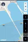
All of these different area restrictions can be confusing to this newbie. To help me understand some of it I have an area I want to fly in and it looks to be a Class D area because of a nearby airport. Looking at the Airmap app it is showing a 400' limit but the warnings are saying I can only get automatic authorization below 200'. Flying a Mini2. Attaching a screenshot of the area. Can someone explain this to me? Thanks!

You are using an out of date browser. It may not display this or other websites correctly.
You should upgrade or use an alternative browser.
You should upgrade or use an alternative browser.
Do I need to get approval to fly here?
- Thread starter spudster
- Start date
MARK (LI)
Well-Known Member

Recoveryone
Well-Known Member
- Joined
- Jul 21, 2019
- Messages
- 530
- Reactions
- 637
- Age
- 63
just submit your flight plan via Airmap, B4UFly or any other LAANC service app and see what comes back. You will either get approved or not and it will tell you what your limits are. If it comes back with a "Further info needed" message you will need FAA authorization/clearance
You are near FMY and there WILL be planes in that area .... I know I was flying there just a couple of weeks ago.... you are also on the edge of RSW's class C but that starts at 1200' which is why the GA guys are at 1000' there normally
Get permission, stay below the altitude allowed, you'll be fine.
Either that or stay on the north side of the river ....
That area can be a tad sketchy, a big homeless problem YMMV
The railroad draw bridge further up river is a great flight, especially when there is a train going over... somewhere on YT there is someone following a Seminole RR Dinner train northbound.
Try The Boathouse Tiki Hut & Grill up on Rt 31....

 www.google.com
Get permission, stay below the altitude allowed, you'll be fine.
Either that or stay on the north side of the river ....
That area can be a tad sketchy, a big homeless problem YMMV
The railroad draw bridge further up river is a great flight, especially when there is a train going over... somewhere on YT there is someone following a Seminole RR Dinner train northbound.
Try The Boathouse Tiki Hut & Grill up on Rt 31....
Google Maps
Find local businesses, view maps and get driving directions in Google Maps.
www.google.com
brett8883
Well-Known Member
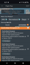
You need to get authorization through LAANC via AirMap to fly within the circle. You can only request up to a maximum height of what is listed inside the box.All of these different area restrictions can be confusing to this newbie. To help me understand some of it I have an area I want to fly in and it looks to be a Class D area because of a nearby airport. Looking at the Airmap app it is showing a 400' limit but the warnings are saying I can only get automatic authorization below 200'. Flying a Mini2. Attaching a screenshot of the area. Can someone explain this to me? Thanks!
Right now you don’t have a specific flight plan made up in AirMap so it’s telling you all the nearby restrictions. When you submit your flight plan as long as you don’t have it going into any 200 ft boxes you can request up to the maximum 400 ft.
Up to 400 ft example flight plan

Up to 200 ft example flight plan

Thanks for all the info everyone. The screenshots I posted are from Airmap and b4ufly. I just wasn't sure if I was headed in the right direction. I want to be sure I learn the right way to fly safely.You are near FMY and there WILL be planes in that area .... I know I was flying there just a couple of weeks ago.... you are also on the edge of RSW's class C but that starts at 1200' which is why the GA guys are at 1000' there normally
....
I'm from the area so plan on investigating further east up the Caloosahatchee. It's just that Lofton's Island (between the Edison spans) used to be all wooded. It's been pretty much cleared out and the owner is planning making it an recreation area of it. Would like to get some shots of it as it is now and see how it progresses over time.
I am familiar with Lofton's, hopefully they will do something good with it, and not ruin it like they did with Downtown Fort Myers (the former home of one of the greatest bike nights in the country)
PS the story behind Lofton's is pretty interesting
PS the story behind Lofton's is pretty interesting
Thank you for explaining that and giving examples. Helps a lot.You need to get authorization through LAANC via AirMap to fly within the circle. You can only request up to a maximum height of what is listed inside the box.
....
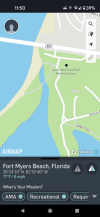
OK, here is another "can I fly here" question that some may think is dumb. I know that you can't fly in Florida state parks. Looking at the map in Airmap they show the state park restrictions in green but there is no green area on the beach itself (see attached). Does this mean that it can be flown on the shoreline? Not that I would want to fly over the beach shoreline, just off shore, but just trying to figure out what these maps are telling me so I can make sure I'm doing things right.
Attachments
brett8883
Well-Known Member
Even for the State Park you can fly over it you just can’t take off and land there if they don’t allow it.OK, here is another "can I fly here" question that some may think is dumb. I know that you can't fly in Florida state parks. Looking at the map in Airmap they show the state park restrictions in green but there is no green area on the beach itself (see attached). Does this mean that it can be flown on the shoreline? Not that I would want to fly over the beach shoreline, just off shore, but just trying to figure out what these maps are telling me so I can make sure I'm doing things right.
For this one you can certainly fly over the beach and I have no reason to believe you can’t take off and land there but this would be a local issue not on AirMap as far as if there’s an ordinance against it or something.
Again, I don’t have any reason to believe there is an ordinance against
Try low tide and TO/land in the tidal zone if in doubt... tidal zone throughout the US coast is federal land.
MARK (LI)
Well-Known Member
So...can anyone make the request to fly here?...or just if you have 107 Cert?You need to get authorization through LAANC via AirMap to fly within the circle. You can only request up to a maximum height of what is listed inside the box.
Right now you don’t have a specific flight plan made up in AirMap so it’s telling you all the nearby restrictions. When you submit your flight plan as long as you don’t have it going into any 200 ft boxes you can request up to the maximum 400 ft.
Up to 400 ft example flight plan
View attachment 128339
Up to 200 ft example flight plan View attachment 128340
I was able to get approval as a recreational flyer. Using a Mini 2.So...can anyone make the request to fly here?...or just if you have 107 Cert?
brett8883
Well-Known Member
Anyone can get authorization up to the height in the boxes on the map.So...can anyone make the request to fly here?...or just if you have 107 Cert?
Part 107 pilots can get authorization for heights above what is indicated in the boxes but recreational pilots cannot. Any request from recreational pilots for heights above what is indicated on the map will be immediately and automatically rejected.
Zeprider
Well-Known Member
I have simply used DJI Fly to get authorization in these same circumstances. No problemo. I just get a code. Is this the same as a LAANC request?
brett8883
Well-Known Member
No and this is really really important.I have simply used DJI Fly to get authorization in these same circumstances. No problemo. I just get a code. Is this the same as a LAANC request?
The DJI system is their own unrelated to the process of getting legal authorization from the FAA. In many cases you may need to do both but DJI’s system is less restrictive so in most instances you need FAA authorization through LAANC via AirMap or Kittyhawk but DJI won’t require you to do anything at all. This is why you should check AirMap or KittyHawk before every flight.
This is the major criticism of DJI’s system in that that make it seem so official and make you jump through so many hoops that people think they’ve done what they need to do when in reality they haven’t at all.
If DJI is making you do the code thing there’s almost a 100% chance you also need to get authorization through LAANC.
Was Loftin's Island this cleared out when you visited? Just took this today.I know I was flying there just a couple of weeks ago....
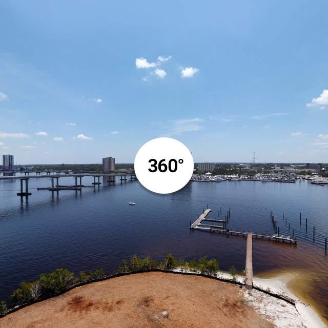
Fort Myers FL
Virtual Tour | Interesting spots around Fort Myers | Loftons island 05/01/2021 - Fort Myers FL
Similar threads
- Replies
- 10
- Views
- 547
- Replies
- 2
- Views
- 357
- Replies
- 7
- Views
- 824
- Replies
- 6
- Views
- 517
- Replies
- 2
- Views
- 583


DJI Drone Deals
Members online
Total: 1,437 (members: 14, guests: 1,423)
Forum statistics
