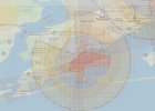
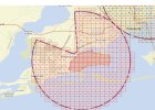
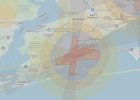
Someone recently posted a question about flying near Pensacola, Florida. Out of curiosity, I compared DJI's FlySafe map for the area to the FAA's UAS Facility Map, which defines controlled airspace for drone operations. I thought the results might be interesting to some folks.
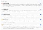
The image below overlays the FAA's definition of controlled airspace to the zones that FlySafe shows. The number grids in the UAS Facility Map are the maximum AGL altitudes allowed if the pilot has received LAANC authorization. The individual maps and the DJI zone color code legend are included below.
FlySafe does not warn you of all controlled airspace. The DJI Restricted Zones don not include all locations within controlled airspace and not even all those with a 0' altitude maximum. Don't depend on the DJI system alone to keep your drone out of controlled airspace.


