You are using an out of date browser. It may not display this or other websites correctly.
You should upgrade or use an alternative browser.
You should upgrade or use an alternative browser.
Drone in the park
- Thread starter wardtom084
- Start date
Is there a statement or a question associated with this map???? I Am confused by this posting.
HoozierDroneDaddy
Well-Known Member
- Joined
- Mar 12, 2017
- Messages
- 885
- Reactions
- 590
- Age
- 71
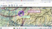
Well we all know it is illegal to fly in the park. Here we have sky vector telling the world that there is drone flying at this location up to 12k. I would like to know why and what it is for.Is there a statement or a question associated with this map???? I Am confused by this posting.
R
rcanboy27
Guest
The only thing I can think of is that this is a wilderness area and the highest point in the area and the lowest point for an aircraft to fly is 7000ft according to the graphics. I am confused because you do not get waiver to fly in this area unless the drone operator is a fish and wildlife employee or a government agency conducting some kind of research.Well we all know it is illegal to fly in the park. Here we have sky vector telling the world that there is drone flying at this location up to 12k. I would like to know why and what it is for.
Similar threads
- Replies
- 4
- Views
- 1K
- Replies
- 26
- Views
- 2K
- Replies
- 13
- Views
- 950
- Replies
- 6
- Views
- 1K
- Replies
- 3
- Views
- 952
Share:
DJI Drone Deals
New Threads
-
-
-
-
-
Advice Please! My 2s needs repair should I sell, repair, buy new?
- Started by Greatsign1
- Replies: 5


